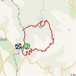
![](/images/other/stat-length.png)
![Trail Walking Voutezac - Ayen-160623 - Ceyrat-FontaineCrozes - Photo](https://media.geolcdn.com/t/1900/400/ext.pjpeg?maxdim=2&url=https%3A%2F%2Fservices.sitytrail.com%2FGeolivesWS%2FDownloadMedia.ashx%3FTrailID%3D588114%26Media%3Dfix__20160623115501.jpg)
Ayen-160623 - Ceyrat-FontaineCrozes
randodan
User
![Length](/images/other/stat-length.png)
![Max alt](https://static1.geolcdn.com/siteimages/upload/files/1508320355ic_sort_altitude_max_24dp.png)
![Uphill gradient](https://static1.geolcdn.com/siteimages/upload/files/1508320355ic_sort_den_pos_24dp.png)
![Km-Effort](/images/other/stat-length.png)
![Min alt](https://static1.geolcdn.com/siteimages/upload/files/1508320355ic_sort_altitude_min_24dp.png)
![Downhill gradient](https://static1.geolcdn.com/siteimages/upload/files/1508320355ic_sort_den_neg_24dp.png)
![Boucle](https://static1.geolcdn.com/siteimages/upload/files/16400158638029165_repeat_loop_refresh_sync_direction_icon.png)
![Walking](https://static1.geolcdn.com/sitytour/trail-icons/101.png)
2h35
Difficulty : Medium
![Scan this QR Code to open this trail in the SityTrail application](https://capi.geolives.com/qq0zvz2zws4bq2lad0pu/sitytour/trails/588114/qr.png?size=200)
FREE GPS app for hiking
About
Trail Walking of 7.5 km to be discovered at New Aquitaine, Corrèze, Voutezac. This trail is proposed by randodan.
Description
Ayen, 23 juin 2016<br>
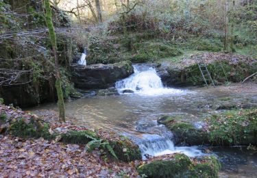
- La Fontaine des Crozes -<br>
<small>(d'après la fiche du C.G. Corrèze)</small><br>
9h45, départ de Ceyrat (en Corrèze, pas Puy-de-Dôme !).<br>
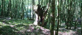
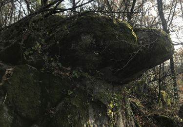
Bonne grimpette dans les bois jusqu'à 'Les Pères' . De la-haut, beau panorama et on essaie de situer notre VVF . Un peu de marche au soleil, puis on replonge dans la verdure du bois du Vaysset.<br>
Oups, mon GPS me rappelle à l'ordre : on s'écarte du circuit prévu . Normal, le panneau et la prise du sentier sont complètement enfouis dans un énorme massif d'orties ! Suivent quelques autres passages, limite hors piste, où la végétation nous oblige à improviser.<br>
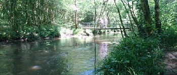
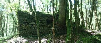
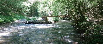
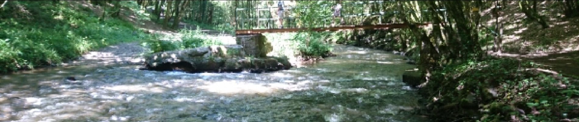
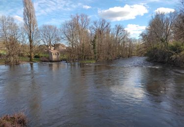
Sans le coup d’oeil infaillible de Maurice, alors que nous étions prêts à traverser la Loyre, nous aurions raté la Fontaine des Crozes, précisément le but de cette rando . Une 1ère passerelle sur la Loyre (pas la Loire ;o), de vieilles ruines (Patel), une 2e passerelle, puis terminons le long d'une carrière très poussiéreuse.<br
12h20 à la voiture. La plus belle rando du coin !<br>
3 participants (Mi,Mo,Da).
Points of interest
Positioning
Comments
Trails nearby
![Trail Walking Lascaux - La Tine - Lascaux - Photo](https://media.geolcdn.com/t/375/260/ext.jpg?maxdim=2&url=https%3A%2F%2Fservices.sitytrail.com%2FGeolivesWS%2FDownloadMedia.ashx%3FTrailID%3D362600%26Media%3D175ef391-a279-4982-8858-a5aae8bf4699.JPG)
![Walking Walking](https://static1.geolcdn.com/sitytour/trail-icons/101.png)
Walking
![](/images/other/stat-length.png)
![](https://static1.geolcdn.com/siteimages/upload/files/16400158638029165_repeat_loop_refresh_sync_direction_icon.png)
![Trail Walking Allassac - w-frankrijk-gorges-du-saillant - Photo](https://media.geolcdn.com/t/375/260/ext.jpg?maxdim=2&url=https%3A%2F%2Fstatic1.geolcdn.com%2Fsiteimages%2Fupload%2Ffiles%2F1553511878bg_sport_marche.png)
![Walking Walking](https://static1.geolcdn.com/sitytour/trail-icons/101.png)
Walking
![](/images/other/stat-length.png)
![](https://static1.geolcdn.com/siteimages/upload/files/16400158638029165_repeat_loop_refresh_sync_direction_icon.png)
![Trail Trail Voutezac - 20201226 Saillant 20.5K - Photo](https://media.geolcdn.com/t/375/260/aafc407f-9bee-4f49-b687-53727b6a5044.jpg&format=jpg&maxdim=2)
![Trail Trail](https://static1.geolcdn.com/sitytour/trail-icons/104.png)
Trail
![](/images/other/stat-length.png)
![](https://static1.geolcdn.com/siteimages/upload/files/16400158638029165_repeat_loop_refresh_sync_direction_icon.png)
![Trail Walking Voutezac - Le Saillant - Vallée de la Vézère - Photo](https://media.geolcdn.com/t/375/260/ext.jpg?maxdim=2&url=https%3A%2F%2Fstatic1.geolcdn.com%2Fsiteimages%2Fupload%2Ffiles%2F1553511878bg_sport_marche.png)
![Walking Walking](https://static1.geolcdn.com/sitytour/trail-icons/101.png)
Walking
![](/images/other/stat-length.png)
![](https://static1.geolcdn.com/siteimages/upload/files/16400158638029165_repeat_loop_refresh_sync_direction_icon.png)
![Trail Walking Allassac - Boucle du vieux Saillant - Photo](https://media.geolcdn.com/t/375/260/ext.jpg?maxdim=2&url=https%3A%2F%2Fservices.sitytrail.com%2FGeolivesWS%2FDownloadMedia.ashx%3FTrailID%3D831256%26Media%3De7220420-f8f1-4549-a9ee-5307c0697031.JPG)
![Walking Walking](https://static1.geolcdn.com/sitytour/trail-icons/101.png)
Walking
![](/images/other/stat-length.png)
![](https://static1.geolcdn.com/siteimages/upload/files/16400158638029165_repeat_loop_refresh_sync_direction_icon.png)
![Trail Walking Voutezac - Les coteaux de Vertougit - Voutezac - Photo](https://media.geolcdn.com/t/375/260/ext.jpg?maxdim=2&url=https%3A%2F%2Fservices.sitytrail.com%2FGeolivesWS%2FDownloadMedia.ashx%3FTrailID%3D318028%26Media%3D17491_3.jpg)
![Walking Walking](https://static1.geolcdn.com/sitytour/trail-icons/101.png)
Walking
![](/images/other/stat-length.png)
![](https://static1.geolcdn.com/siteimages/upload/files/16400158638029165_repeat_loop_refresh_sync_direction_icon.png)
![Trail Walking Voutezac - La fontaine des Crozes - Voutezac - Photo](https://media.geolcdn.com/t/375/260/ext.jpg?maxdim=2&url=https%3A%2F%2Fservices.sitytrail.com%2FGeolivesWS%2FDownloadMedia.ashx%3FTrailID%3D318027%26Media%3D17490_3.jpg)
![Walking Walking](https://static1.geolcdn.com/sitytour/trail-icons/101.png)
Walking
![](/images/other/stat-length.png)
![](https://static1.geolcdn.com/siteimages/upload/files/16400158638029165_repeat_loop_refresh_sync_direction_icon.png)
![Trail Walking Allassac - cirque du saillant - Photo](https://media.geolcdn.com/t/375/260/02c3300b-7239-493a-8490-eafa087c8a92.jpg&format=jpg&maxdim=2)
![Walking Walking](https://static1.geolcdn.com/sitytour/trail-icons/101.png)
Walking
![](/images/other/stat-length.png)
![](https://static1.geolcdn.com/siteimages/upload/files/16400158638029165_repeat_loop_refresh_sync_direction_icon.png)
![Trail Motorbike Allassac - Rocher du diable - Photo](https://media.geolcdn.com/t/375/260/0a13996c-2b51-4b44-aa5b-663accdc6b35.jpg&format=jpg&maxdim=2)
![Motorbike Motorbike](https://static1.geolcdn.com/sitytour/trail-icons/402.png)
Motorbike
![](/images/other/stat-length.png)
![](https://static1.geolcdn.com/siteimages/upload/files/16400158638029165_repeat_loop_refresh_sync_direction_icon.png)