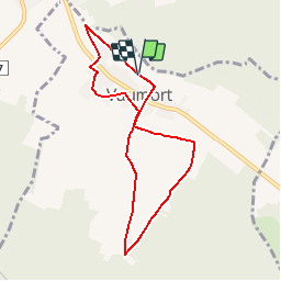
![](/images/other/stat-length.png)
![Trail Walking Vaumort - Vaumort-Cirduit du menhir - Photo](https://media.geolcdn.com/t/1900/400/ext.pjpeg?maxdim=2&url=https%3A%2F%2Fstatic1.geolcdn.com%2Fsiteimages%2Fupload%2Ffiles%2F1553511878bg_sport_marche.png)
Vaumort-Cirduit du menhir
ccvpo
User
![Length](/images/other/stat-length.png)
![Max alt](https://static1.geolcdn.com/siteimages/upload/files/1508320355ic_sort_altitude_max_24dp.png)
![Uphill gradient](https://static1.geolcdn.com/siteimages/upload/files/1508320355ic_sort_den_pos_24dp.png)
![Km-Effort](/images/other/stat-length.png)
![Min alt](https://static1.geolcdn.com/siteimages/upload/files/1508320355ic_sort_altitude_min_24dp.png)
![Downhill gradient](https://static1.geolcdn.com/siteimages/upload/files/1508320355ic_sort_den_neg_24dp.png)
![Boucle](https://static1.geolcdn.com/siteimages/upload/files/16400158638029165_repeat_loop_refresh_sync_direction_icon.png)
![Walking](https://static1.geolcdn.com/sitytour/trail-icons/101.png)
1h59
Difficulty : Easy
![Scan this QR Code to open this trail in the SityTrail application](https://capi.geolives.com/qq0zvz2zws4bq2lad0pu/sitytour/trails/586994/qr.png?size=200)
FREE GPS app for hiking
About
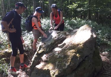
Trail Walking of 7.2 km to be discovered at Bourgogne-Franche-Comté, Yonne, Vaumort. This trail is proposed by ccvpo.
Description
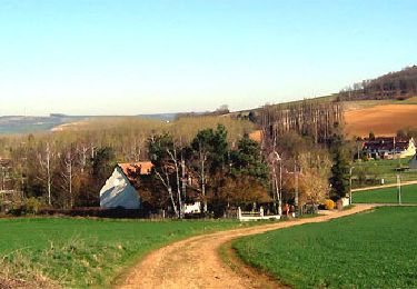
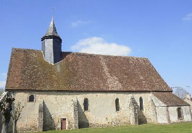
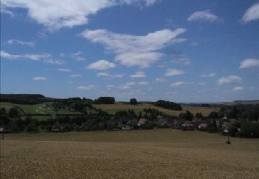
Randonnée autour de Vaumort, son église, l’élevage de chèvres du Vallimaurais et le menhir « la pierre aux sorciers » avant de monter vers la forêt et la vallée de Vaumartinpour plus d'informations: http://www.vanne-et-othe.com/randos-village.phpDépart place de l’église St-Jean-Baptiste du XIIIème siècle, se diriger sur le chemin herbeux qui rejoint la route à 900 m.Virer à gauche à l’angle aigu et descendre la route de la Collate sur 360 m.Prendre à droite le premier chemin vers la D 905. La traverser et prendre en face le chemin herbeux qui rejoint la route des Vauliards.Tourner à gauche et rejoindre le carrefour à 110 mètres.Prendre à droite la route de Dixmont,Puis à 330 mètres la rue de la Lampe. Passer devant l’élevage de chèvres 13bis rue de la Lampe visite de l’élevage de chèvres possible sur RV (tel 03-86-88-34-15)Passer devant l'ancien lavoir.A l'intersection continuer à droite sur la rue de la Lampe.A 40 m à gauche, se dresse un menhir « la pierre aux sorciers » sur une propriété privée.Continuer la route sur 270 m.Emprunter à droite le chemin, (la rue du Terrier), qui gravit la côte sur 1,750 km.Virer à gauche à l’angle aigu. Suivre le chemin qui traverse le bois sur 160 m. Descendre en lisière de forêt sur 1 km, continuer sur 300 mètresRejoindre la petite route et la suivre sur 300 m.Prendre à gauche le chemin herbeux jusqu’au chemin empierré.Tourner à droite et descendre le chemin. Continuer en face par la rue du Terrier.Traverser la D 905 et gravir en face le chemin de l’église.Tourner à gauche et arriver au parking.
Positioning
Comments
Trails nearby
![Trail Walking Noé - Noé 240330 - Photo](https://media.geolcdn.com/t/375/260/534a27cb-b940-433b-9376-6f8d2fb02f7a.jpg&format=jpg&maxdim=2)
![Walking Walking](https://static1.geolcdn.com/sitytour/trail-icons/101.png)
Walking
![](/images/other/stat-length.png)
![](https://static1.geolcdn.com/siteimages/upload/files/16400158638029165_repeat_loop_refresh_sync_direction_icon.png)
![Trail Walking Les Vallées de la Vanne - Theil sur Vanne 230618 - Photo](https://media.geolcdn.com/t/375/260/fa588dcd-1f8a-497b-803e-9cfe8dcc8e61.jpg&format=jpg&maxdim=2)
![Walking Walking](https://static1.geolcdn.com/sitytour/trail-icons/101.png)
Walking
![](/images/other/stat-length.png)
![](https://static1.geolcdn.com/siteimages/upload/files/16400158638029165_repeat_loop_refresh_sync_direction_icon.png)
![Trail Walking Villiers-Louis - Villiers-Louis 230325 - Photo](https://media.geolcdn.com/t/375/260/e64ca8ab-7358-4cca-a459-3a9f0545c584.jpg&format=jpg&maxdim=2)
![Walking Walking](https://static1.geolcdn.com/sitytour/trail-icons/101.png)
Walking
![](/images/other/stat-length.png)
![](https://static1.geolcdn.com/siteimages/upload/files/16400158638029165_repeat_loop_refresh_sync_direction_icon.png)
![Trail Walking Les Vallées de la Vanne - De bourg en hameaux - Vareilles - Photo](https://media.geolcdn.com/t/375/260/ext.jpg?maxdim=2&url=https%3A%2F%2Fservices.sitytrail.com%2FGeolivesWS%2FDownloadMedia.ashx%3FTrailID%3D191642%26Media%3D15289_5.jpg)
![Walking Walking](https://static1.geolcdn.com/sitytour/trail-icons/101.png)
Walking
![](/images/other/stat-length.png)
![](https://static1.geolcdn.com/siteimages/upload/files/16400158638029165_repeat_loop_refresh_sync_direction_icon.png)
![Trail Walking Les Vallées de la Vanne - Le bois du Champ-Fêtu - Vareilles - Photo](https://media.geolcdn.com/t/375/260/ext.jpg?maxdim=2&url=https%3A%2F%2Fservices.sitytrail.com%2FGeolivesWS%2FDownloadMedia.ashx%3FTrailID%3D191641%26Media%3D15288_1.jpg)
![Walking Walking](https://static1.geolcdn.com/sitytour/trail-icons/101.png)
Walking
![](/images/other/stat-length.png)
![](https://static1.geolcdn.com/siteimages/upload/files/16400158638029165_repeat_loop_refresh_sync_direction_icon.png)
![Trail Walking Les Vallées de la Vanne - Vareilles - Les Thorets - Photo](https://media.geolcdn.com/t/375/260/ext.jpg?maxdim=2&url=https%3A%2F%2Fservices.sitytrail.com%2FGeolivesWS%2FDownloadMedia.ashx%3FTrailID%3D150185%26Media%3D02922737-c5ff-444f-a4d6-41ebc13620e2.jpg)
![Walking Walking](https://static1.geolcdn.com/sitytour/trail-icons/101.png)
Walking
![](/images/other/stat-length.png)
![](https://static1.geolcdn.com/siteimages/upload/files/16400158638029165_repeat_loop_refresh_sync_direction_icon.png)
![Trail Walking Les Vallées de la Vanne - A la découverte de Chigy et la Vallée de la Vanne - Photo](https://media.geolcdn.com/t/375/260/ext.jpg?maxdim=2&url=https%3A%2F%2Fservices.sitytrail.com%2FGeolivesWS%2FDownloadMedia.ashx%3FTrailID%3D111423%26Media%3D7216_4.jpg)
![Walking Walking](https://static1.geolcdn.com/sitytour/trail-icons/101.png)
Walking
![](/images/other/stat-length.png)
![](https://static1.geolcdn.com/siteimages/upload/files/16400158638029165_repeat_loop_refresh_sync_direction_icon.png)
![Trail Walking Cerisiers - Rando de la pomme - Photo](https://media.geolcdn.com/t/375/260/5f809d82-ab23-4d4e-9732-858f73532dcb.jpg&format=jpg&maxdim=2)
![Walking Walking](https://static1.geolcdn.com/sitytour/trail-icons/101.png)
Walking
![](/images/other/stat-length.png)
![](https://static1.geolcdn.com/siteimages/upload/files/16400158638029165_repeat_loop_refresh_sync_direction_icon.png)
![Trail Walking Noé - Karine ( MICHEL ) - Photo](https://media.geolcdn.com/t/375/260/4275bdd6-58d5-4c2f-8a2b-b997023c34a1.jpg&format=jpg&maxdim=2)
![Walking Walking](https://static1.geolcdn.com/sitytour/trail-icons/101.png)
Walking
![](/images/other/stat-length.png)
![](https://static1.geolcdn.com/siteimages/upload/files/16400158638029165_repeat_loop_refresh_sync_direction_icon.png)