dandole SityTrail > Trails > Outdoor > Spain > Autonomous Community of the Basque Country > Álava > Vitoria-Gasteiz SityTrail > Trails > Outdoor > Spain > Autonomous Community of the Basque Country > Álava > Vitoria-Gasteiz dandole PeterArrieta User 3D © OpenStreetMap contributors Length 68 km Max alt 684 m Uphill gradient 620 m Km-Effort 76 km Min alt 505 m Downhill gradient 626 m Boucle No Creation date : 2016-06-16 00:00:00.0 Updated on : 2016-06-16 00:00:00.0 (0 Reviews) Other activity 1h58 Difficulty : Unknown FREE GPS app for hiking SityTrail IGN / Geographical institutes SityTrail World The world is yours! About 
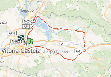
Trail Other activity of 68 km to be discovered at Autonomous Community of the Basque Country, Álava, Vitoria-Gasteiz. This trail is proposed by PeterArrieta. Legends | More details (PDF) Elevation profile Legends > 15% 15% - 10% 10% - 5% flat 5% - 10% 10% - 15% 15% - 30% > 30% Positioning Country: Spain Region : Autonomous Community of the Basque Country Department/Province : Álava Municipality : Vitoria-Gasteiz Location: Betoño Start:(Dec) 42.854515 / -2.648206 Start:(UTM) 528742 ; 4744719 (30T) N. Comments Please log in to post a review or rate the element Trails nearby GUIDE+ SL-GI 10 Oñati Ekialdea: Aloñapeko ibilbidea On foot Easy Oñati, Autonomous Community of the Basque Country, Gipuzkoa, Spain 8.9 km | 12.7 km-effort 2h 53min No GUIDE+ Camino del Puerto de Vitoria al monte Arrieta On foot Easy Condado de Treviño, Castile and León, Unknown, Spain 3.4 km | 4.4 km-effort 1h 0min No