Trail Walking Amurrio - Amurrio - Photo
© OpenStreetMap contributors
Length
Length
6.2 km
Max alt
Max alt
398 m
Uphill gradient
Uphill gradient
135 m
Km-Effort
Km-Effort  
7.9 km
Min alt
Min alt
308 m
Downhill gradient
Downhill gradient
131 m
Boucle
Boucle
Yes
Creation date :
2016-06-15 00:00:00.0
Updated on :
2016-06-15 00:00:00.0

(0 Reviews)

Walking
Walking
1h43
Difficulty : Very easy

Scan this QR Code to open this trail in the SityTrail application

FREE GPS app for hiking

Logo SityTrail SityTrail

IGN / Geographical institutes

Download SityTrail from the App Store Download SityTrail from Google Play

Logo SityTrail SityTrail World

The world is yours!

Download SityTrail from the App Store Download SityTrail from Google Play Download SityTrail on Huawei AppGallery

About

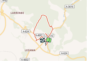
Trail Walking of 6.2 km to be discovered at Autonomous Community of the Basque Country, Álava, Amurrio. This trail is proposed by jpipacific.

Description

Ballade  autour de l'hôtel pour passer le temps car il pleut sans arrêt. Normal nous sommes en pays basque...

Elevation profile

Positioning

Country:
Spain
Region :
Autonomous Community of the Basque Country
Department/Province :
Álava
Municipality :
Amurrio
Location:
Lezama
Start:(UTM)
503159 ; 4764230 (30T) N.

Trails nearby

Trail Motor Orduña-Urduña - tour serra salvada - Photo
Motor
jpipacific

Motor

Easy
Orduña-Urduña, Autonomous Community of the Basque Country, Biscay, Spain
113 km | 147 km-effort
2h 30min
No
Trail Moto cross Orduña-Urduña - Sierra Salvada - Photo
Moto cross
jpipacific

Moto cross

Medium
Orduña-Urduña, Autonomous Community of the Basque Country, Biscay, Spain
95 km | 125 km-effort
5h 0min
No
Trail Motor Orduña-Urduña - Mirador del Nervion - Photo
Motor
jpipacific

Motor

Very easy
Orduña-Urduña, Autonomous Community of the Basque Country, Biscay, Spain
51 km | 65 km-effort
2h 40min
Yes


Close
My subscriptions