![](/images/other/stat-length.png)
![Trail Other activity Mangonville - mangonville3 - Photo](https://media.geolcdn.com/t/1900/400/ext.pjpeg?maxdim=2&url=https%3A%2F%2Fstatic1.geolcdn.com%2Fsiteimages%2Fupload%2Ffiles%2F1545311037marcheuse_200dpi.jpg)
mangonville3
zibane54
User
![Length](/images/other/stat-length.png)
Length
52 km
![Max alt](https://static1.geolcdn.com/siteimages/upload/files/1508320355ic_sort_altitude_max_24dp.png)
Max alt
358 m
![Uphill gradient](https://static1.geolcdn.com/siteimages/upload/files/1508320355ic_sort_den_pos_24dp.png)
Uphill gradient
639 m
![Km-Effort](/images/other/stat-length.png)
Km-Effort
60 km
![Min alt](https://static1.geolcdn.com/siteimages/upload/files/1508320355ic_sort_altitude_min_24dp.png)
Min alt
233 m
![Downhill gradient](https://static1.geolcdn.com/siteimages/upload/files/1508320355ic_sort_den_neg_24dp.png)
Downhill gradient
639 m
![Boucle](https://static1.geolcdn.com/siteimages/upload/files/16400158638029165_repeat_loop_refresh_sync_direction_icon.png)
Boucle
Yes
Creation date :
2016-05-15 00:00:00.0
Updated on :
2016-05-15 00:00:00.0
![Other activity](https://static1.geolcdn.com/sitytour/trail-icons/900.png)
2h30
Difficulty : Medium
![Scan this QR Code to open this trail in the SityTrail application](https://capi.geolives.com/qq0zvz2zws4bq2lad0pu/sitytour/trails/569216/qr.png?size=200)
FREE GPS app for hiking
About
Trail Other activity of 52 km to be discovered at Grand Est, Meurthe-et-Moselle, Mangonville. This trail is proposed by zibane54.
Description
un joli parcours plat sur les premiers KM puis vallonné ensuite. Seule petite difficulté la traversée de villacourt, la petite route pour loromontzey est mal indiqué (mais elle est sympa)
Positioning
Country:
France
Region :
Grand Est
Department/Province :
Meurthe-et-Moselle
Municipality :
Mangonville
Location:
Unknown
Start:(Dec)
Start:(UTM)
299605 ; 5370559 (32U) N.
Comments
Trails nearby
![Trail Cycle Mangonville - mangonville - Photo](https://media.geolcdn.com/t/375/260/ext.jpg?maxdim=2&url=https%3A%2F%2Fstatic1.geolcdn.com%2Fsiteimages%2Fupload%2Ffiles%2F1524743154velo.jpg)
![Cycle Cycle](https://static1.geolcdn.com/sitytour/trail-icons/200.png)
mangonville
Cycle
Easy
(2)
Mangonville,
Grand Est,
Meurthe-et-Moselle,
France
![](/images/other/stat-length.png)
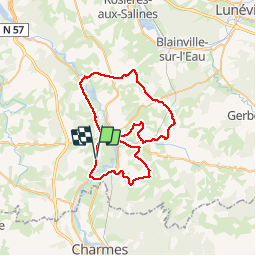
43 km | 50 km-effort
2h 52min
![](https://static1.geolcdn.com/siteimages/upload/files/16400158638029165_repeat_loop_refresh_sync_direction_icon.png)
No
![Trail Walking Bayon - Etang Bayon - Photo](https://media.geolcdn.com/t/375/260/ext.jpg?maxdim=2&url=https%3A%2F%2Fstatic1.geolcdn.com%2Fsiteimages%2Fupload%2Ffiles%2F1553511878bg_sport_marche.png)
![Walking Walking](https://static1.geolcdn.com/sitytour/trail-icons/101.png)
Etang Bayon
Walking
Easy
Bayon,
Grand Est,
Meurthe-et-Moselle,
France
![](/images/other/stat-length.png)
3.4 km | 3.6 km-effort
1h 14min
![](https://static1.geolcdn.com/siteimages/upload/files/16400158638029165_repeat_loop_refresh_sync_direction_icon.png)
Yes
![Trail Electric bike Bainville-aux-Miroirs - sortie vtt sion 04082022 - Photo](https://media.geolcdn.com/t/375/260/ext.jpg?maxdim=2&url=https%3A%2F%2Fstatic1.geolcdn.com%2Fsiteimages%2Fupload%2Ffiles%2F1524743154velo.jpg)
![Electric bike Electric bike](https://static1.geolcdn.com/sitytour/trail-icons/205.png)
sortie vtt sion 04082022
Electric bike
Difficult
Bainville-aux-Miroirs,
Grand Est,
Meurthe-et-Moselle,
France
![](/images/other/stat-length.png)
51 km | 62 km-effort
3h 22min
![](https://static1.geolcdn.com/siteimages/upload/files/16400158638029165_repeat_loop_refresh_sync_direction_icon.png)
Yes
![Trail Electric bike Bainville-aux-Miroirs - sortie vtt 08052022 luca - Photo](https://media.geolcdn.com/t/375/260/ext.jpg?maxdim=2&url=https%3A%2F%2Fstatic1.geolcdn.com%2Fsiteimages%2Fupload%2Ffiles%2F1524743154velo.jpg)
![Electric bike Electric bike](https://static1.geolcdn.com/sitytour/trail-icons/205.png)
sortie vtt 08052022 luca
Electric bike
Medium
Bainville-aux-Miroirs,
Grand Est,
Meurthe-et-Moselle,
France
![](/images/other/stat-length.png)
42 km | 50 km-effort
2h 36min
![](https://static1.geolcdn.com/siteimages/upload/files/16400158638029165_repeat_loop_refresh_sync_direction_icon.png)
Yes
![Trail Horseback riding Froville - acpl chez Karine et Danielle froville - Photo](https://media.geolcdn.com/t/375/260/ext.jpg?maxdim=2&url=https%3A%2F%2Fstatic1.geolcdn.com%2Fsiteimages%2Fupload%2Ffiles%2F1524743154cheval.jpg)
![Horseback riding Horseback riding](https://static1.geolcdn.com/sitytour/trail-icons/301.png)
acpl chez Karine et Danielle froville
Horseback riding
Medium
Froville,
Grand Est,
Meurthe-et-Moselle,
France
![](/images/other/stat-length.png)
21 km | 24 km-effort
3h 11min
![](https://static1.geolcdn.com/siteimages/upload/files/16400158638029165_repeat_loop_refresh_sync_direction_icon.png)
Yes
![Trail Walking Mangonville - pipistrelle - Photo](https://media.geolcdn.com/t/375/260/ext.jpg?maxdim=2&url=https%3A%2F%2Fstatic1.geolcdn.com%2Fsiteimages%2Fupload%2Ffiles%2F1553511878bg_sport_marche.png)
![Walking Walking](https://static1.geolcdn.com/sitytour/trail-icons/101.png)
pipistrelle
Walking
Mangonville,
Grand Est,
Meurthe-et-Moselle,
France
![](/images/other/stat-length.png)
9.9 km | 11.9 km-effort
2h 45min
![](https://static1.geolcdn.com/siteimages/upload/files/16400158638029165_repeat_loop_refresh_sync_direction_icon.png)
Yes
![Trail Walking Bayon - la saussaie Bayon 10km - Photo](https://media.geolcdn.com/t/375/260/4b873303-590d-4338-9afc-7d6de0f50bbd.jpg&format=jpg&maxdim=2)
![Walking Walking](https://static1.geolcdn.com/sitytour/trail-icons/101.png)
la saussaie Bayon 10km
Walking
Medium
(1)
Bayon,
Grand Est,
Meurthe-et-Moselle,
France
![](/images/other/stat-length.png)
9.9 km | 11.1 km-effort
2h 36min
![](https://static1.geolcdn.com/siteimages/upload/files/16400158638029165_repeat_loop_refresh_sync_direction_icon.png)
Yes
![Trail Walking Virecourt - Bayon Charmes - Photo](https://media.geolcdn.com/t/375/260/ext.jpg?maxdim=2&url=https%3A%2F%2Fstatic1.geolcdn.com%2Fsiteimages%2Fupload%2Ffiles%2F1553511878bg_sport_marche.png)
![Walking Walking](https://static1.geolcdn.com/sitytour/trail-icons/101.png)
Bayon Charmes
Walking
Medium
Virecourt,
Grand Est,
Meurthe-et-Moselle,
France
![](/images/other/stat-length.png)
22 km | 25 km-effort
4h 56min
![](https://static1.geolcdn.com/siteimages/upload/files/16400158638029165_repeat_loop_refresh_sync_direction_icon.png)
No
![Trail Walking Roville-devant-Bayon - Roville devant Bayon - Photo](https://media.geolcdn.com/t/375/260/ext.jpg?maxdim=2&url=https%3A%2F%2Fstatic1.geolcdn.com%2Fsiteimages%2Fupload%2Ffiles%2F1553511878bg_sport_marche.png)
![Walking Walking](https://static1.geolcdn.com/sitytour/trail-icons/101.png)
Roville devant Bayon
Walking
Easy
Roville-devant-Bayon,
Grand Est,
Meurthe-et-Moselle,
France
![](/images/other/stat-length.png)
12.9 km | 15.7 km-effort
3h 25min
![](https://static1.geolcdn.com/siteimages/upload/files/16400158638029165_repeat_loop_refresh_sync_direction_icon.png)
Yes