![](/images/other/stat-length.png)
![Trail Walking Bages - 66 BAGES promenade sur Les crêtes,Panorama sur les Albères, Et sur le lac de VILLENEUVE DE LA RAHO - Photo](https://media.geolcdn.com/t/1900/400/ext.pjpeg?maxdim=2&url=https%3A%2F%2Fstatic1.geolcdn.com%2Fsiteimages%2Fupload%2Ffiles%2F1553511878bg_sport_marche.png)
66 BAGES promenade sur Les crêtes,Panorama sur les Albères, Et sur le lac de VILLENEUVE DE LA RAHO
jeff66
User
![Length](/images/other/stat-length.png)
Length
7.8 km
![Max alt](https://static1.geolcdn.com/siteimages/upload/files/1508320355ic_sort_altitude_max_24dp.png)
Max alt
46 m
![Uphill gradient](https://static1.geolcdn.com/siteimages/upload/files/1508320355ic_sort_den_pos_24dp.png)
Uphill gradient
76 m
![Km-Effort](/images/other/stat-length.png)
Km-Effort
8.8 km
![Min alt](https://static1.geolcdn.com/siteimages/upload/files/1508320355ic_sort_altitude_min_24dp.png)
Min alt
11 m
![Downhill gradient](https://static1.geolcdn.com/siteimages/upload/files/1508320355ic_sort_den_neg_24dp.png)
Downhill gradient
77 m
![Boucle](https://static1.geolcdn.com/siteimages/upload/files/16400158638029165_repeat_loop_refresh_sync_direction_icon.png)
Boucle
Yes
Creation date :
2016-05-17 00:00:00.0
Updated on :
2016-05-17 00:00:00.0
![Walking](https://static1.geolcdn.com/sitytour/trail-icons/101.png)
1h27
Difficulty : Easy
![Scan this QR Code to open this trail in the SityTrail application](https://capi.geolives.com/qq0zvz2zws4bq2lad0pu/sitytour/trails/568234/qr.png?size=200)
FREE GPS app for hiking
About
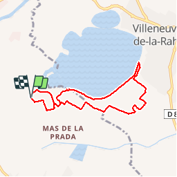
Trail Walking of 7.8 km to be discovered at Occitania, Pyrénées-Orientales, Bages. This trail is proposed by jeff66.
Description
66 BAGES, Vulpillères, La Llantia, promenade sur Les crêtes,Panorama sur les Albères, Et sur le lac de VILLENEUVE DE LA RAHO, LA Sobrepera, Els Etanyots, Val Marie, stade - Salle polyvalente - Pétanque - tennis, Mas Doat, le Lac
Positioning
Country:
France
Region :
Occitania
Department/Province :
Pyrénées-Orientales
Municipality :
Bages
Location:
Unknown
Start:(Dec)
Start:(UTM)
490679 ; 4719102 (31T) N.
Comments
Trails nearby
![Trail Quad Montescot - Villeneuve-de-la-Raho-Collioure (Septembre/Juin) - Photo](https://media.geolcdn.com/t/375/260/4ff70784-96c3-45ae-a310-36bc0ac2c85e.jpg&format=jpg&maxdim=2)
![Quad Quad](https://static1.geolcdn.com/sitytour/trail-icons/404.png)
Villeneuve-de-la-Raho-Collioure (Septembre/Juin)
Quad
Medium
(1)
Montescot,
Occitania,
Pyrénées-Orientales,
France
![](/images/other/stat-length.png)
33 km | 40 km-effort
1h 45min
![](https://static1.geolcdn.com/siteimages/upload/files/16400158638029165_repeat_loop_refresh_sync_direction_icon.png)
No
![Trail Walking Montescot - 66 VILLENEUVE-DE-LA-RAHO grand tour du lac en Sens horaire - Photo](https://media.geolcdn.com/t/375/260/ext.jpg?maxdim=2&url=https%3A%2F%2Fservices.sitytrail.com%2FGeolivesWS%2FDownloadMedia.ashx%3FTrailID%3D526864%26Media%3D20160209171243.jpg)
![Walking Walking](https://static1.geolcdn.com/sitytour/trail-icons/101.png)
66 VILLENEUVE-DE-LA-RAHO grand tour du lac en Sens horaire
Walking
Easy
(1)
Montescot,
Occitania,
Pyrénées-Orientales,
France
![](/images/other/stat-length.png)
6.7 km | 7.5 km-effort
1h 4min
![](https://static1.geolcdn.com/siteimages/upload/files/16400158638029165_repeat_loop_refresh_sync_direction_icon.png)
Yes
![Trail Walking Saint-Jean-Lasseille - ST-JEAN-LASSEILLE 66 - terroirs des Aspres - Photo](https://media.geolcdn.com/t/375/260/ext.jpg?maxdim=2&url=https%3A%2F%2Fservices.sitytrail.com%2FGeolivesWS%2FDownloadMedia.ashx%3FTrailID%3D419934%26Media%3D20150512183916.jpg)
![Walking Walking](https://static1.geolcdn.com/sitytour/trail-icons/101.png)
ST-JEAN-LASSEILLE 66 - terroirs des Aspres
Walking
Easy
(1)
Saint-Jean-Lasseille,
Occitania,
Pyrénées-Orientales,
France
![](/images/other/stat-length.png)
12.2 km | 14.3 km-effort
2h 6min
![](https://static1.geolcdn.com/siteimages/upload/files/16400158638029165_repeat_loop_refresh_sync_direction_icon.png)
Yes
![Trail Walking Villeneuve-de-la-Raho - 66 VILLENEUVE-DE-LA-RAHO - grand tour périphérique du lac par les lignes de crêtes - Photo](https://media.geolcdn.com/t/375/260/ext.jpg?maxdim=2&url=https%3A%2F%2Fstatic1.geolcdn.com%2Fsiteimages%2Fupload%2Ffiles%2F1553511878bg_sport_marche.png)
![Walking Walking](https://static1.geolcdn.com/sitytour/trail-icons/101.png)
66 VILLENEUVE-DE-LA-RAHO - grand tour périphérique du lac par les lignes de c...
Walking
Easy
(2)
Villeneuve-de-la-Raho,
Occitania,
Pyrénées-Orientales,
France
![](/images/other/stat-length.png)
10 km | 11.5 km-effort
1h 44min
![](https://static1.geolcdn.com/siteimages/upload/files/16400158638029165_repeat_loop_refresh_sync_direction_icon.png)
Yes
![Trail Mountain bike Canohès - canohes - Photo](https://media.geolcdn.com/t/375/260/ext.jpg?maxdim=2&url=https%3A%2F%2Fstatic1.geolcdn.com%2Fsiteimages%2Fupload%2Ffiles%2F1524743154velo.jpg)
![Mountain bike Mountain bike](https://static1.geolcdn.com/sitytour/trail-icons/202.png)
canohes
Mountain bike
Medium
(2)
Canohès,
Occitania,
Pyrénées-Orientales,
France
![](/images/other/stat-length.png)
37 km | 44 km-effort
2h 12min
![](https://static1.geolcdn.com/siteimages/upload/files/16400158638029165_repeat_loop_refresh_sync_direction_icon.png)
Yes
![Trail Quad Villeneuve-de-la-Raho - Villeneuve-de-la-Raho-Collioure(Juillet-Aout) - Photo](https://media.geolcdn.com/t/375/260/94b9111a-30bb-4d36-9ee6-84d7d83dae26.jpg&format=jpg&maxdim=2)
![Quad Quad](https://static1.geolcdn.com/sitytour/trail-icons/404.png)
Villeneuve-de-la-Raho-Collioure(Juillet-Aout)
Quad
Very easy
(1)
Villeneuve-de-la-Raho,
Occitania,
Pyrénées-Orientales,
France
![](/images/other/stat-length.png)
39 km | 44 km-effort
1h 40min
![](https://static1.geolcdn.com/siteimages/upload/files/16400158638029165_repeat_loop_refresh_sync_direction_icon.png)
No
![Trail Walking Perpignan - Perpignan - Photo](https://media.geolcdn.com/t/375/260/904ff4bb-4f73-47d8-906f-dc7922d74f80.jpg&format=jpg&maxdim=2)
![Walking Walking](https://static1.geolcdn.com/sitytour/trail-icons/101.png)
Perpignan
Walking
Very easy
Perpignan,
Occitania,
Pyrénées-Orientales,
France
![](/images/other/stat-length.png)
18 km | 19.9 km-effort
2h 23min
![](https://static1.geolcdn.com/siteimages/upload/files/16400158638029165_repeat_loop_refresh_sync_direction_icon.png)
No
![Trail Walking Perpignan - canal Perpignan - Photo](https://media.geolcdn.com/t/375/260/ext.jpg?maxdim=2&url=https%3A%2F%2Fservices.sitytrail.com%2FGeolivesWS%2FDownloadMedia.ashx%3FTrailID%3D745865%26Media%3Dfix__20170316151123.jpg)
![Walking Walking](https://static1.geolcdn.com/sitytour/trail-icons/101.png)
canal Perpignan
Walking
Very easy
Perpignan,
Occitania,
Pyrénées-Orientales,
France
![](/images/other/stat-length.png)
25 km | 27 km-effort
7h 29min
![](https://static1.geolcdn.com/siteimages/upload/files/16400158638029165_repeat_loop_refresh_sync_direction_icon.png)
No
![Trail Walking Montescot - 66 VILLENEUVE-DE-LA-RAHO grand tour du lac en Sens horaire - Photo](https://media.geolcdn.com/t/375/260/ext.jpg?maxdim=2&url=https%3A%2F%2Fservices.sitytrail.com%2FGeolivesWS%2FDownloadMedia.ashx%3FTrailID%3D534696%26Media%3D20160209172607.jpg)
![Walking Walking](https://static1.geolcdn.com/sitytour/trail-icons/101.png)
66 VILLENEUVE-DE-LA-RAHO grand tour du lac en Sens horaire
Walking
Easy
Montescot,
Occitania,
Pyrénées-Orientales,
France
![](/images/other/stat-length.png)
6.7 km | 7.5 km-effort
1h 4min
![](https://static1.geolcdn.com/siteimages/upload/files/16400158638029165_repeat_loop_refresh_sync_direction_icon.png)
Yes