Trail Cycle Souspierre - col de la Chaudiere - Photo
 Gerbers
Gerbers

User

© OpenStreetMap contributors
Length
Length
95 km
Max alt
Max alt
1057 m
Uphill gradient
Uphill gradient
2031 m
Km-Effort
Km-Effort  
122 km
Min alt
Min alt
204 m
Downhill gradient
Downhill gradient
2031 m
Boucle
Boucle
Yes
Creation date :
2016-05-13 00:00:00.0
Updated on :
2016-05-13 00:00:00.0

(0 Reviews)

Cycle
Cycle
6h59
Difficulty : Medium

Scan this QR Code to open this trail in the SityTrail application

FREE GPS app for hiking

Logo SityTrail SityTrail

IGN / Geographical institutes

Download SityTrail from the App Store Download SityTrail from Google Play

Logo SityTrail SityTrail World

The world is yours!

Download SityTrail from the App Store Download SityTrail from Google Play Download SityTrail on Huawei AppGallery

About

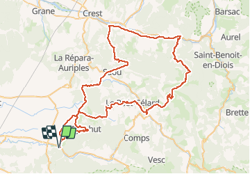
Trail Cycle of 95 km to be discovered at Auvergne-Rhône-Alpes, Drôme, Souspierre. This trail is proposed by Gerbers.

Description

Souspierre D179, vervolg D179, Eyzahut D263, D183 Pont de Barret, klein stukje D179, Rochebaudin D328, Vervolg D328 tot Poet Celard, vervolg D328 tot Bourdeaux, klein stukje D538 Saou/Mornans, Col de la Chaudiere D156, na col afdalen tot Saillans, klein stukje richting Crest D93, richting Aubenasson D164b blijven volgen tot rotonde D164, vervolg over D164, Saou D70, vervolg D70 tot Saou, klein stukje richting Crest D136, vervolg D136 tot voorbij Soyans, Pont de Barret D128, Pont de Barret door, Salettes D179 doorrijden D179 tot Souspierre. plus info www.revechatoyant.com

Elevation profile

Positioning

Country:
France
Region :
Auvergne-Rhône-Alpes
Department/Province :
Drôme
Municipality :
Souspierre
Location:
Unknown
Start:(UTM)
655671 ; 4933559 (31T) N.

Trails nearby

Trail On foot Eyzahut - SityTrail - Boucle 1 - Photo
On foot
Julie LABBE

On foot

Very difficult
(2)
Eyzahut, Auvergne-Rhône-Alpes, Drôme, France
17.3 km | 31 km-effort
6h 0min
Yes
Trail Walking Portes-en-Valdaine - GPX-Rando-Plaine-Portoise-nouvelleversion - Photo
Walking
GUIDE
thonyc

Walking

Easy
(1)
Portes-en-Valdaine, Auvergne-Rhône-Alpes, Drôme, France
7.1 km | 8.2 km-effort
2h 0min
Yes
Trail Walking Portes-en-Valdaine - Portes-en-Valdaine Serre-de-Mirabel 11km. - Photo
Walking
chancha

Walking

Difficult
(1)
Portes-en-Valdaine, Auvergne-Rhône-Alpes, Drôme, France
10.8 km | 14.7 km-effort
3h 20min
Yes
Trail Walking Portes-en-Valdaine - 26 portes en valdaine - Photo
Walking
GUIDE
randodyssée

Walking

Very easy
Portes-en-Valdaine, Auvergne-Rhône-Alpes, Drôme, France
10.6 km | 14.5 km-effort
4h 10min
Yes
Trail Walking Aleyrac - 26 autour aleyrac - Photo
Walking
GUIDE
randodyssée

Walking

Easy
Aleyrac, Auvergne-Rhône-Alpes, Drôme, France
12.4 km | 15.7 km-effort
4h 50min
No
Trail Walking Le Poët-Laval - Le poët laval - Photo
Walking
orlandiniluc

Walking

Medium
(1)
Le Poët-Laval, Auvergne-Rhône-Alpes, Drôme, France
9.8 km | 17.8 km-effort
4h 21min
Yes
Trail Walking Le Poët-Laval - le Poët-Laval et le trou du furet - Photo
Walking
GUIDE
amiral13

Walking

Very easy
Le Poët-Laval, Auvergne-Rhône-Alpes, Drôme, France
7.5 km | 14.3 km-effort
4h 3min
Yes
Trail Walking La Bégude-de-Mazenc - La Bégude de Mazenc - Serre de Forillon - Photo
Walking
tracegps

Walking

Medium
(1)
La Bégude-de-Mazenc, Auvergne-Rhône-Alpes, Drôme, France
8.1 km | 12 km-effort
2h 30min
Yes
Trail Cycle La Bégude-de-Mazenc - La Roche St Secret - Photo
Cycle
tracegps

Cycle

Medium
(1)
La Bégude-de-Mazenc, Auvergne-Rhône-Alpes, Drôme, France
46 km | 56 km-effort
2h 10min
Yes


Close
My subscriptions