Trail Cycle Souspierre - Dieulefit col valouse - Photo
 Gerbers
Gerbers

User

© OpenStreetMap contributors
Length
Length
79 km
Max alt
Max alt
792 m
Uphill gradient
Uphill gradient
1549 m
Km-Effort
Km-Effort  
99 km
Min alt
Min alt
235 m
Downhill gradient
Downhill gradient
1548 m
Boucle
Boucle
Yes
Creation date :
2016-05-13 00:00:00.0
Updated on :
2016-05-13 00:00:00.0

(0 Reviews)

Cycle
Cycle
5h44
Difficulty : Medium

Scan this QR Code to open this trail in the SityTrail application

FREE GPS app for hiking

Logo SityTrail SityTrail

IGN / Geographical institutes

Download SityTrail from the App Store Download SityTrail from Google Play

Logo SityTrail SityTrail World

The world is yours!

Download SityTrail from the App Store Download SityTrail from Google Play Download SityTrail on Huawei AppGallery

About

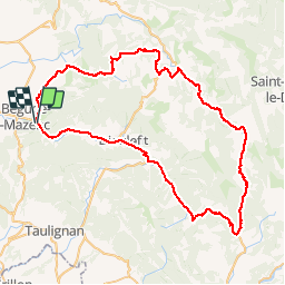
Trail Cycle of 79 km to be discovered at Auvergne-Rhône-Alpes, Drôme, Souspierre. This trail is proposed by Gerbers.

Description

Dieulefit D540 , Nyons D538, La Pailette D130, Vervold D130, Bouvieres D70 Vervolg D70 tot Bourdeaux, Dieulefit D538, Poet Celard D328a, D328 tot Rochebaudin, D328 vervolgen, Salettes D179, Souspierre D179

Elevation profile

Positioning

Country:
France
Region :
Auvergne-Rhône-Alpes
Department/Province :
Drôme
Municipality :
Souspierre
Location:
Unknown
Start:(UTM)
655704 ; 4933597 (31T) N.

Trails nearby

Trail On foot Eyzahut - SityTrail - Boucle 1 - Photo
On foot
Julie LABBE

On foot

Very difficult
(2)
Eyzahut, Auvergne-Rhône-Alpes, Drôme, France
17.3 km | 31 km-effort
6h 0min
Yes
Trail Walking Portes-en-Valdaine - GPX-Rando-Plaine-Portoise-nouvelleversion - Photo
Walking
GUIDE
thonyc

Walking

Easy
(1)
Portes-en-Valdaine, Auvergne-Rhône-Alpes, Drôme, France
7.1 km | 8.2 km-effort
2h 0min
Yes
Trail Walking Portes-en-Valdaine - Portes-en-Valdaine Serre-de-Mirabel 11km. - Photo
Walking
chancha

Walking

Difficult
(1)
Portes-en-Valdaine, Auvergne-Rhône-Alpes, Drôme, France
10.8 km | 14.7 km-effort
3h 20min
Yes
Trail Walking Portes-en-Valdaine - 26 portes en valdaine - Photo
Walking
GUIDE
randodyssée

Walking

Very easy
Portes-en-Valdaine, Auvergne-Rhône-Alpes, Drôme, France
10.6 km | 14.5 km-effort
4h 10min
Yes
Trail Walking Le Poët-Laval - Le poët laval - Photo
Walking
orlandiniluc

Walking

Medium
(1)
Le Poët-Laval, Auvergne-Rhône-Alpes, Drôme, France
9.8 km | 17.8 km-effort
4h 21min
Yes
Trail Walking Le Poët-Laval - le Poët-Laval et le trou du furet - Photo
Walking
GUIDE
amiral13

Walking

Very easy
Le Poët-Laval, Auvergne-Rhône-Alpes, Drôme, France
7.5 km | 14.3 km-effort
4h 3min
Yes
Trail Walking La Bégude-de-Mazenc - La Bégude de Mazenc - Serre de Forillon - Photo
Walking
tracegps

Walking

Medium
(1)
La Bégude-de-Mazenc, Auvergne-Rhône-Alpes, Drôme, France
8.1 km | 12 km-effort
2h 30min
Yes
Trail Cycle La Bégude-de-Mazenc - La Roche St Secret - Photo
Cycle
tracegps

Cycle

Medium
(1)
La Bégude-de-Mazenc, Auvergne-Rhône-Alpes, Drôme, France
46 km | 56 km-effort
2h 10min
Yes
Trail Walking Le Poët-Laval - Poët-Laval Les vitrouilléres (La Dame Blanche) 9km. - Photo
Walking
chancha

Walking

Medium
Le Poët-Laval, Auvergne-Rhône-Alpes, Drôme, France
8.7 km | 11.5 km-effort
2h 37min
Yes


Close
My subscriptions