![](/images/other/stat-length.png)
![Trail Walking Dinant - GR 129 Sud : Dinant > Houyet - Photo](https://media.geolcdn.com/t/1900/400/ext.pjpeg?maxdim=2&url=https%3A%2F%2Fstatic1.geolcdn.com%2Fsiteimages%2Fupload%2Ffiles%2F1553511878bg_sport_marche.png)
GR 129 Sud : Dinant > Houyet
jojolemarcheur
User
![Length](/images/other/stat-length.png)
Length
26 km
![Max alt](https://static1.geolcdn.com/siteimages/upload/files/1508320355ic_sort_altitude_max_24dp.png)
Max alt
294 m
![Uphill gradient](https://static1.geolcdn.com/siteimages/upload/files/1508320355ic_sort_den_pos_24dp.png)
Uphill gradient
475 m
![Km-Effort](/images/other/stat-length.png)
Km-Effort
32 km
![Min alt](https://static1.geolcdn.com/siteimages/upload/files/1508320355ic_sort_altitude_min_24dp.png)
Min alt
91 m
![Downhill gradient](https://static1.geolcdn.com/siteimages/upload/files/1508320355ic_sort_den_neg_24dp.png)
Downhill gradient
454 m
![Boucle](https://static1.geolcdn.com/siteimages/upload/files/16400158638029165_repeat_loop_refresh_sync_direction_icon.png)
Boucle
No
Creation date :
2016-05-10 00:00:00.0
Updated on :
2016-05-10 00:00:00.0
![Walking](https://static1.geolcdn.com/sitytour/trail-icons/101.png)
6h51
Difficulty : Medium
![Scan this QR Code to open this trail in the SityTrail application](https://capi.geolives.com/qq0zvz2zws4bq2lad0pu/sitytour/trails/567087/qr.png?size=200)
FREE GPS app for hiking
About
Trail Walking of 26 km to be discovered at Wallonia, Namur, Dinant. This trail is proposed by jojolemarcheur.
Description
Grimpée en zig zag au départ de Dinant. Entre Gendron et Houyet le long de la Lesse, sentier très escarpé par moment et descente de deux échelles métalliques à pic !!!.
Positioning
Country:
Belgium
Region :
Wallonia
Department/Province :
Namur
Municipality :
Dinant
Location:
Dinant
Start:(Dec)
Start:(UTM)
635964 ; 5569450 (31U) N.
Comments
Trails nearby
![Walking Walking](https://static1.geolcdn.com/sitytour/trail-icons/101.png)
RB-Na-24-Entre Lesse et Meuse
Walking
Very difficult
(15)
Dinant,
Wallonia,
Namur,
Belgium
![](/images/other/stat-length.png)
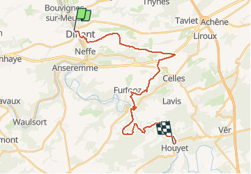
19.3 km | 26 km-effort
5h 57min
![](https://static1.geolcdn.com/siteimages/upload/files/16400158638029165_repeat_loop_refresh_sync_direction_icon.png)
Yes
![Trail Walking Yvoir - RB-Na-03 Forteresses, citadelle et abbaye mosanes - Photo](https://media.geolcdn.com/t/375/260/ext.jpg?maxdim=2&url=https%3A%2F%2Fservices.sitytrail.com%2FGeolivesWS%2FDownloadMedia.ashx%3FTrailID%3D179628%26Media%3D8266bb1a-850d-41b8-8bad-8e0bd7c82bf9.jpg)
![Walking Walking](https://static1.geolcdn.com/sitytour/trail-icons/101.png)
RB-Na-03 Forteresses, citadelle et abbaye mosanes
Walking
Difficult
(11)
Yvoir,
Wallonia,
Namur,
Belgium
![](/images/other/stat-length.png)
22 km | 30 km-effort
7h 1min
![](https://static1.geolcdn.com/siteimages/upload/files/16400158638029165_repeat_loop_refresh_sync_direction_icon.png)
Yes
![Trail Walking Dinant - Balade à Dinant - La Réserve Naturelle de Moniat - Photo](https://media.geolcdn.com/t/375/260/765b9b62-b29c-4537-9ff6-9d29c15be9d8.jpg&format=jpg&maxdim=2)
![Walking Walking](https://static1.geolcdn.com/sitytour/trail-icons/101.png)
Balade à Dinant - La Réserve Naturelle de Moniat
Walking
Very easy
(1)
Dinant,
Wallonia,
Namur,
Belgium
![](/images/other/stat-length.png)
8.4 km | 10.9 km-effort
3h 54min
![](https://static1.geolcdn.com/siteimages/upload/files/16400158638029165_repeat_loop_refresh_sync_direction_icon.png)
Yes
![Trail Walking Dinant - D'Anseremme à Dinant - Photo](https://media.geolcdn.com/t/375/260/ext.jpg?maxdim=2&url=https%3A%2F%2Fservices.sitytrail.com%2FGeolivesWS%2FDownloadMedia.ashx%3FTrailID%3D375788%26Media%3D9ffb86bd-da6e-4936-82b7-07dbdf349394.JPG)
![Walking Walking](https://static1.geolcdn.com/sitytour/trail-icons/101.png)
D'Anseremme à Dinant
Walking
Easy
(3)
Dinant,
Wallonia,
Namur,
Belgium
![](/images/other/stat-length.png)
8.3 km | 11.8 km-effort
2h 34min
![](https://static1.geolcdn.com/siteimages/upload/files/16400158638029165_repeat_loop_refresh_sync_direction_icon.png)
Yes
![Trail Walking Dinant - Balade à Bouvignes - Photo](https://media.geolcdn.com/t/375/260/ext.jpg?maxdim=2&url=https%3A%2F%2Fservices.sitytrail.com%2FGeolivesWS%2FDownloadMedia.ashx%3FTrailID%3D223072%26Media%3D8dae2923-6a84-4680-856b-d65e95092209.JPG)
![Walking Walking](https://static1.geolcdn.com/sitytour/trail-icons/101.png)
Balade à Bouvignes
Walking
Easy
(3)
Dinant,
Wallonia,
Namur,
Belgium
![](/images/other/stat-length.png)
4.8 km | 7.2 km-effort
1h 34min
![](https://static1.geolcdn.com/siteimages/upload/files/16400158638029165_repeat_loop_refresh_sync_direction_icon.png)
Yes
![Trail Walking Dinant - Balade en Réserve Naturelle de Devant Bouvignes - Photo](https://media.geolcdn.com/t/375/260/ext.jpg?maxdim=2&url=https%3A%2F%2Fservices.sitytrail.com%2FGeolivesWS%2FDownloadMedia.ashx%3FTrailID%3D222999%26Media%3D231bd4cd-9ad4-4a88-bcf6-84f0725ce446.JPG)
![Walking Walking](https://static1.geolcdn.com/sitytour/trail-icons/101.png)
Balade en Réserve Naturelle de Devant Bouvignes
Walking
Very easy
(3)
Dinant,
Wallonia,
Namur,
Belgium
![](/images/other/stat-length.png)
4.9 km | 6.9 km-effort
1h 32min
![](https://static1.geolcdn.com/siteimages/upload/files/16400158638029165_repeat_loop_refresh_sync_direction_icon.png)
Yes
![Trail Walking Anhée - rando ornitho haut le wastia 01/04/2021 - Photo](https://media.geolcdn.com/t/375/260/6351cc8d-4bd0-44ad-b76a-97c195daeb77.jpg&format=jpg&maxdim=2)
![Walking Walking](https://static1.geolcdn.com/sitytour/trail-icons/101.png)
rando ornitho haut le wastia 01/04/2021
Walking
Easy
(2)
Anhée,
Wallonia,
Namur,
Belgium
![](/images/other/stat-length.png)
12.9 km | 16.4 km-effort
4h 44min
![](https://static1.geolcdn.com/siteimages/upload/files/16400158638029165_repeat_loop_refresh_sync_direction_icon.png)
Yes
![Trail Walking Dinant - Dinant: autour de la Citadelle. - Photo](https://media.geolcdn.com/t/375/260/0debd692-1141-41b3-8018-db8fdb788a39.jpg&format=jpg&maxdim=2)
![Walking Walking](https://static1.geolcdn.com/sitytour/trail-icons/101.png)
Dinant: autour de la Citadelle.
Walking
Easy
(4)
Dinant,
Wallonia,
Namur,
Belgium
![](/images/other/stat-length.png)
5.7 km | 7.5 km-effort
1h 40min
![](https://static1.geolcdn.com/siteimages/upload/files/16400158638029165_repeat_loop_refresh_sync_direction_icon.png)
Yes
![Walking Walking](https://static1.geolcdn.com/sitytour/trail-icons/101.png)
RB-Na-24-racc-Entre Lesse et Meuse
Walking
Very difficult
(4)
Dinant,
Wallonia,
Namur,
Belgium
![](/images/other/stat-length.png)
18.5 km | 24 km-effort
5h 29min
![](https://static1.geolcdn.com/siteimages/upload/files/16400158638029165_repeat_loop_refresh_sync_direction_icon.png)
Yes