Trail Walking Terre-de-Bas - Anse à dos par route du Nord de Terre de Bas - Photo

Anse à dos par route du Nord de Terre de Bas

 guiller
guiller

User

© OpenStreetMap contributors
Length
Length
4.5 km
Max alt
Max alt
236 m
Uphill gradient
Uphill gradient
194 m
Km-Effort
Km-Effort  
7.3 km
Min alt
Min alt
6 m
Downhill gradient
Downhill gradient
255 m
Boucle
Boucle
No
Creation date :
2016-05-07 00:00:00.0
Updated on :
2016-05-07 00:00:00.0

(0 Reviews)

Walking
Walking
1h21
Difficulty : Easy

Scan this QR Code to open this trail in the SityTrail application

FREE GPS app for hiking

Logo SityTrail SityTrail

IGN / Geographical institutes

Download SityTrail from the App Store Download SityTrail from Google Play

Logo SityTrail SityTrail World

The world is yours!

Download SityTrail from the App Store Download SityTrail from Google Play Download SityTrail on Huawei AppGallery

About

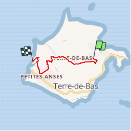
Trail Walking of 4.5 km to be discovered at Guadeloupe, Unknown, Terre-de-Bas. This trail is proposed by guiller.

Description

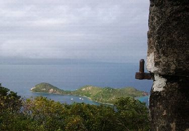
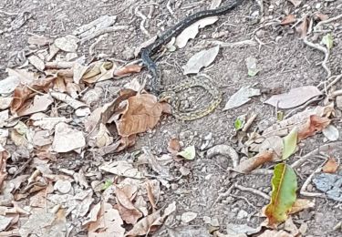
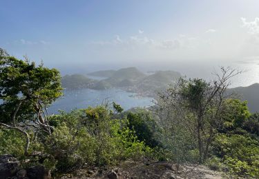
départ de Rêve  de Robinson avant 8h30 si possible pour avoir de l'ombre  dans la côte.  1h25 en s'arrêtant prendre à manger et à boire dans l'une  des 4 epiceries de Petite Anse. Plage sable gris clair avec palmiers et abris, barbecue, poubelles et douches. Beau spot de snorkeling 1 gauche. Il y a aussi quelques iguanes

Elevation profile

Positioning

Country:
France
Region :
Guadeloupe
Department/Province :
Unknown
Municipality :
Terre-de-Bas
Location:
Unknown
Start:(UTM)
647049 ; 1753441 (20P) N.

Trails nearby

Trail Walking Terre-de-Haut - Les Saintes - Photo
Walking
sphinkie

Walking

Medium
Terre-de-Haut, Guadeloupe, Unknown, France
16.3 km | 25 km-effort
5h 26min
Yes
Trail Walking Terre-de-Bas - terre de bas rouge et bleue - Photo
Walking
Yannick971

Walking

Medium
Terre-de-Bas, Guadeloupe, Unknown, France
3.6 km | 6.4 km-effort
2h 2min
No
Trail Walking Terre-de-Bas - Boucle Petite Anse - Grande Anse - Photo
Walking
loic09

Walking

Easy
Terre-de-Bas, Guadeloupe, Unknown, France
10.2 km | 15.2 km-effort
2h 48min
Yes
Trail Walking Terre-de-Haut - cascade tambour  - Photo
Walking
Gerty Dhaussy

Walking

Very easy
Terre-de-Haut, Guadeloupe, Unknown, France
42 km | 68 km-effort
3h 47min
No
Trail Walking Terre-de-Haut - Morne du chameau - les saintes - Photo
Walking
jps13

Walking

Very difficult
Terre-de-Haut, Guadeloupe, Unknown, France
6.4 km | 11.5 km-effort
1h 27min
No
Trail Walking Terre-de-Haut - Le Chameau Terre de haut - Photo
Walking
Jean-Marc Golberg

Walking

Medium
Terre-de-Haut, Guadeloupe, Unknown, France
2.6 km | 6.2 km-effort
1h 46min
Yes
Trail Walking Terre-de-Bas - saintes trace jaune  - Photo
Walking
bruno lohest

Walking

Medium
Terre-de-Bas, Guadeloupe, Unknown, France
6.8 km | 11.4 km-effort
3h 15min
Yes
Trail On foot Terre-de-Haut - Découverte de la Terre-des-Hauts de l'archipel des Saintes  - Photo
On foot
Jo-Guide

On foot

Easy
Terre-de-Haut, Guadeloupe, Unknown, France
10.7 km | 17 km-effort
3h 52min
Yes
Trail Walking Terre-de-Haut - le chameau terre de haut - Photo
Walking
stephaneddy

Walking

Difficult
Terre-de-Haut, Guadeloupe, Unknown, France
5 km | 8.7 km-effort
2h 22min
Yes


Close
My subscriptions