Trail Walking Fillière - Pas du Roc - Pointe de Puvat - Photo

Pas du Roc - Pointe de Puvat

© OpenStreetMap contributors
Length
Length
11 km
Max alt
Max alt
1883 m
Uphill gradient
Uphill gradient
1188 m
Km-Effort
Km-Effort  
24 km
Min alt
Min alt
923 m
Downhill gradient
Downhill gradient
283 m
Boucle
Boucle
No
Creation date :
2016-10-26 00:00:00.0
Updated on :
2016-10-26 00:00:00.0

(2 Reviews)

Walking
Walking
4h24
Difficulty : Medium

Scan this QR Code to open this trail in the SityTrail application

FREE GPS app for hiking

Logo SityTrail SityTrail

IGN / Geographical institutes

Download SityTrail from the App Store Download SityTrail from Google Play

Logo SityTrail SityTrail World

The world is yours!

Download SityTrail from the App Store Download SityTrail from Google Play Download SityTrail on Huawei AppGallery

About

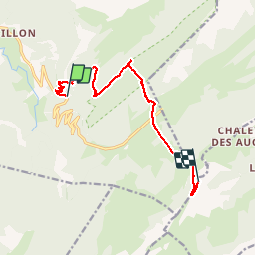
Trail Walking of 11 km to be discovered at Auvergne-Rhône-Alpes, Upper Savoy, Fillière. This trail is proposed by sofracoan.

Description

Aller Simple de la route au pied de la cascade du pas du roc, puis plateau des glières et pointe de Puvat.
Prévoir le retour.

Elevation profile

Positioning

Country:
France
Region :
Auvergne-Rhône-Alpes
Department/Province :
Upper Savoy
Municipality :
Fillière
Location:
Thorens-Glières
Start:(UTM)
290772 ; 5094219 (32T) N.

Comments

Please log in to post a review or rate the element


ok


Trails nearby

Trail Walking Fillière - LE PARMELAN: ANGLETTAZ - GRANDE GLACIERE - GROTTE DE L'ENFER - LAPIAZ - REFUGE... RETOUR PAR GRAND & PETIT MONTOIR - Photo
Walking
djeepee74

Walking

Difficult
(2)
Fillière, Auvergne-Rhône-Alpes, Upper Savoy, France
9 km | 15.6 km-effort
4h 30min
Yes
Trail Walking Fillière - refuge Patmelan via anglettaz . gd glacière . fontaine du tour . grotte de l enfer  / retour via gd montoir et pt montoir  - Photo
Walking
GUIDE
stef789

Walking

Medium
Fillière, Auvergne-Rhône-Alpes, Upper Savoy, France
10.2 km | 16.1 km-effort
6h 1min
Yes
Trail Walking Fillière - tête de l'Apertaz, tête ronde et tête noire - Photo
Walking
GUIDE
nadd73

Walking

Medium
Fillière, Auvergne-Rhône-Alpes, Upper Savoy, France
12.6 km | 21 km-effort
5h 55min
Yes
Trail Walking Fillière - GLIERES: MONUMENT - CHALETS DES AUGES - GAUTARD - Photo
Walking
djeepee74

Walking

Easy
(1)
Fillière, Auvergne-Rhône-Alpes, Upper Savoy, France
8.8 km | 14.5 km-effort
3h 0min
No
Trail Walking Fillière - Les Molliets-Pertuis-Ablon 10 Mai 2018 - Photo
Walking
GUIDE
Kargil

Walking

Difficult
Fillière, Auvergne-Rhône-Alpes, Upper Savoy, France
18.2 km | 32 km-effort
7h 6min
Yes
Trail Walking Fillière - 20170806115426 90167 data - Photo
Walking
domcobe

Walking

Easy
(1)
Fillière, Auvergne-Rhône-Alpes, Upper Savoy, France
3.2 km | 8.6 km-effort
1h 53min
No
Trail Walking Fillière - tour parmelan - Photo
Walking
micfor

Walking

Easy
(2)
Fillière, Auvergne-Rhône-Alpes, Upper Savoy, France
12.9 km | 22 km-effort
4h 0min
Yes
Trail Walking Glières-Val-de-Borne - Refuge de Spé - Photo
Walking
Jocelyn74

Walking

Very easy
(1)
Glières-Val-de-Borne, Auvergne-Rhône-Alpes, Upper Savoy, France
3.7 km | 5 km-effort
Unknown
No
Trail Walking Fillière - chalet de l'angletaz pour Umi - Photo
Walking
Ckikiplus

Walking

Easy
Fillière, Auvergne-Rhône-Alpes, Upper Savoy, France
3.8 km | 5.7 km-effort
1h 11min
Yes


Close
My subscriptions