![](/images/other/stat-length.png)
![Trail Walking Sorède - 66 SOREDE - la vallée heureuse - collada de Llori par la piste - retour par le Tassio - Photo](https://media.geolcdn.com/t/1900/400/ext.pjpeg?maxdim=2&url=https%3A%2F%2Fservices.sitytrail.com%2FGeolivesWS%2FDownloadMedia.ashx%3FTrailID%3D561796%26Media%3D20160429191329.jpg)
66 SOREDE - la vallée heureuse - collada de Llori par la piste - retour par le Tassio
jeff66
User
![Length](/images/other/stat-length.png)
Length
17.1 km
![Max alt](https://static1.geolcdn.com/siteimages/upload/files/1508320355ic_sort_altitude_max_24dp.png)
Max alt
943 m
![Uphill gradient](https://static1.geolcdn.com/siteimages/upload/files/1508320355ic_sort_den_pos_24dp.png)
Uphill gradient
792 m
![Km-Effort](/images/other/stat-length.png)
Km-Effort
28 km
![Min alt](https://static1.geolcdn.com/siteimages/upload/files/1508320355ic_sort_altitude_min_24dp.png)
Min alt
202 m
![Downhill gradient](https://static1.geolcdn.com/siteimages/upload/files/1508320355ic_sort_den_neg_24dp.png)
Downhill gradient
819 m
![Boucle](https://static1.geolcdn.com/siteimages/upload/files/16400158638029165_repeat_loop_refresh_sync_direction_icon.png)
Boucle
Yes
Creation date :
2016-05-02 00:00:00.0
Updated on :
2016-05-02 00:00:00.0
![Walking](https://static1.geolcdn.com/sitytour/trail-icons/101.png)
3h59
Difficulty : Difficult
![Scan this QR Code to open this trail in the SityTrail application](https://capi.geolives.com/qq0zvz2zws4bq2lad0pu/sitytour/trails/561796/qr.png?size=200)
FREE GPS app for hiking
About
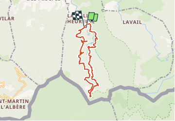
Trail Walking of 17.1 km to be discovered at Occitania, Pyrénées-Orientales, Sorède. This trail is proposed by jeff66.
Description
66 SOREDE - la vallée heureuse - Piste DFCI AL31 - Correc de la Sagueda - la Jaça del Taure - chapelle ruinée Santa Maria Magdalena - Correc de la Tanyareda - collada de Llori - gorges du Tassio - collada de l'Espinas
Positioning
Country:
France
Region :
Occitania
Department/Province :
Pyrénées-Orientales
Municipality :
Sorède
Location:
Unknown
Start:(Dec)
Start:(UTM)
497148 ; 4705855 (31T) N.
Comments
Trails nearby
![Trail Walking Laroque-des-Albères - Laroque-des-Albères, petit tour des mas - Photo](https://media.geolcdn.com/t/375/260/a38763d0-1e12-4df0-8310-6577414297bd.jpg&format=jpg&maxdim=2)
![Walking Walking](https://static1.geolcdn.com/sitytour/trail-icons/101.png)
Laroque-des-Albères, petit tour des mas
Walking
Very easy
(1)
Laroque-des-Albères,
Occitania,
Pyrénées-Orientales,
France
![](/images/other/stat-length.png)
5.4 km | 7.1 km-effort
1h 47min
![](https://static1.geolcdn.com/siteimages/upload/files/16400158638029165_repeat_loop_refresh_sync_direction_icon.png)
Yes
![Trail Walking Laroque-des-Albères - 66 LAROQUE DES ALBERES (maison) SOREDE, par pistes DFCI AL12 et 19, mas del Ca et mas Manere, Itin.16 - Photo](https://media.geolcdn.com/t/375/260/ext.jpg?maxdim=2&url=https%3A%2F%2Fservices.sitytrail.com%2FGeolivesWS%2FDownloadMedia.ashx%3FTrailID%3D585179%26Media%3D20160616145650.jpg)
![Walking Walking](https://static1.geolcdn.com/sitytour/trail-icons/101.png)
66 LAROQUE DES ALBERES (maison) SOREDE, par pistes DFCI AL12 et 19, mas del C...
Walking
Medium
(1)
Laroque-des-Albères,
Occitania,
Pyrénées-Orientales,
France
![](/images/other/stat-length.png)
11.2 km | 15.3 km-effort
2h 5min
![](https://static1.geolcdn.com/siteimages/upload/files/16400158638029165_repeat_loop_refresh_sync_direction_icon.png)
Yes
![Trail Walking Laroque-des-Albères - 66 SOREDE, LAROQUE DES ALBERES, chemins des Mas - Photo](https://media.geolcdn.com/t/375/260/ext.jpg?maxdim=2&url=https%3A%2F%2Fservices.sitytrail.com%2FGeolivesWS%2FDownloadMedia.ashx%3FTrailID%3D534699%26Media%3D20160303171633.jpg)
![Walking Walking](https://static1.geolcdn.com/sitytour/trail-icons/101.png)
66 SOREDE, LAROQUE DES ALBERES, chemins des Mas
Walking
Medium
(1)
Laroque-des-Albères,
Occitania,
Pyrénées-Orientales,
France
![](/images/other/stat-length.png)
7 km | 8.9 km-effort
1h 22min
![](https://static1.geolcdn.com/siteimages/upload/files/16400158638029165_repeat_loop_refresh_sync_direction_icon.png)
Yes
![Trail Walking Sorède - Utrera Font Miracles T - Photo](https://media.geolcdn.com/t/375/260/ext.jpg?maxdim=2&url=https%3A%2F%2Fservices.sitytrail.com%2FGeolivesWS%2FDownloadMedia.ashx%3FTrailID%3D419352%26Media%3Dfix__20150510145313.jpg)
![Walking Walking](https://static1.geolcdn.com/sitytour/trail-icons/101.png)
Utrera Font Miracles T
Walking
Medium
(1)
Sorède,
Occitania,
Pyrénées-Orientales,
France
![](/images/other/stat-length.png)
10.7 km | 17.6 km-effort
3h 50min
![](https://static1.geolcdn.com/siteimages/upload/files/16400158638029165_repeat_loop_refresh_sync_direction_icon.png)
Yes
![Trail Walking Sorède - 577. 11km sorede roc des medes - Photo](https://media.geolcdn.com/t/375/260/61f4e75a-7c25-4df1-b192-fc8eca3c7acc.jpg&format=jpg&maxdim=2)
![Walking Walking](https://static1.geolcdn.com/sitytour/trail-icons/101.png)
577. 11km sorede roc des medes
Walking
Medium
(1)
Sorède,
Occitania,
Pyrénées-Orientales,
France
![](/images/other/stat-length.png)
10.5 km | 18.2 km-effort
3h 42min
![](https://static1.geolcdn.com/siteimages/upload/files/16400158638029165_repeat_loop_refresh_sync_direction_icon.png)
Yes
![Trail Walking Laroque-des-Albères - Col-Ullat Pic-aureille_Terrain - Photo](https://media.geolcdn.com/t/375/260/ext.jpg?maxdim=2&url=https%3A%2F%2Fservices.sitytrail.com%2FGeolivesWS%2FDownloadMedia.ashx%3FTrailID%3D221622%26Media%3Dfix__20130916174240.jpg)
![Walking Walking](https://static1.geolcdn.com/sitytour/trail-icons/101.png)
Col-Ullat Pic-aureille_Terrain
Walking
Medium
(1)
Laroque-des-Albères,
Occitania,
Pyrénées-Orientales,
France
![](/images/other/stat-length.png)
11.2 km | 23 km-effort
4h 47min
![](https://static1.geolcdn.com/siteimages/upload/files/16400158638029165_repeat_loop_refresh_sync_direction_icon.png)
Yes
![Trail Walking Laroque-des-Albères - laroque . four solaire . sorede . laroque - Photo](https://media.geolcdn.com/t/375/260/8277f678-fc05-4b86-85a5-0677abe59742.jpg&format=jpg&maxdim=2)
![Walking Walking](https://static1.geolcdn.com/sitytour/trail-icons/101.png)
laroque . four solaire . sorede . laroque
Walking
Medium
Laroque-des-Albères,
Occitania,
Pyrénées-Orientales,
France
![](/images/other/stat-length.png)
7.7 km | 9.2 km-effort
1h 57min
![](https://static1.geolcdn.com/siteimages/upload/files/16400158638029165_repeat_loop_refresh_sync_direction_icon.png)
Yes
![Trail On foot Sorède - Vallée Heureuse - Château d'Ultrera - Photo](https://media.geolcdn.com/t/375/260/1088733c-d3dc-4898-8e8b-7d7fa684abd6.jpeg&format=jpg&maxdim=2)
![On foot On foot](https://static1.geolcdn.com/sitytour/trail-icons/100.png)
Vallée Heureuse - Château d'Ultrera
On foot
Easy
Sorède,
Occitania,
Pyrénées-Orientales,
France
![](/images/other/stat-length.png)
10.9 km | 19.4 km-effort
4h 23min
![](https://static1.geolcdn.com/siteimages/upload/files/16400158638029165_repeat_loop_refresh_sync_direction_icon.png)
Yes
![Trail Walking Argelès-sur-Mer - Argelès village Plage Port Le Racou - 20.1km 110m 5h25 (30mn) - 2018 09 13 - Photo](https://media.geolcdn.com/t/375/260/ext.jpg?maxdim=2&url=https%3A%2F%2Fservices.sitytrail.com%2FGeolivesWS%2FDownloadMedia.ashx%3FTrailID%3D1042082%26Media%3Dfix__20180913163508.jpg)
![Walking Walking](https://static1.geolcdn.com/sitytour/trail-icons/101.png)
Argelès village Plage Port Le Racou - 20.1km 110m 5h25 (30mn) - 2018 09 13
Walking
Easy
Argelès-sur-Mer,
Occitania,
Pyrénées-Orientales,
France
![](/images/other/stat-length.png)
20 km | 22 km-effort
5h 25min
![](https://static1.geolcdn.com/siteimages/upload/files/16400158638029165_repeat_loop_refresh_sync_direction_icon.png)
Yes