![](/images/other/stat-length.png)
![Trail Walking Font-Romeu-Odeillo-Via - Val Pyrène étang du Ticou - Photo](https://media.geolcdn.com/t/1900/400/ext.pjpeg?maxdim=2&url=https%3A%2F%2Fservices.sitytrail.com%2FGeolivesWS%2FDownloadMedia.ashx%3FTrailID%3D560634%26Media%3D20160429104043.jpg)
Val Pyrène étang du Ticou
crijack
User
![Length](/images/other/stat-length.png)
Length
9.8 km
![Max alt](https://static1.geolcdn.com/siteimages/upload/files/1508320355ic_sort_altitude_max_24dp.png)
Max alt
1770 m
![Uphill gradient](https://static1.geolcdn.com/siteimages/upload/files/1508320355ic_sort_den_pos_24dp.png)
Uphill gradient
249 m
![Km-Effort](/images/other/stat-length.png)
Km-Effort
13.2 km
![Min alt](https://static1.geolcdn.com/siteimages/upload/files/1508320355ic_sort_altitude_min_24dp.png)
Min alt
1603 m
![Downhill gradient](https://static1.geolcdn.com/siteimages/upload/files/1508320355ic_sort_den_neg_24dp.png)
Downhill gradient
249 m
![Boucle](https://static1.geolcdn.com/siteimages/upload/files/16400158638029165_repeat_loop_refresh_sync_direction_icon.png)
Boucle
Yes
Creation date :
2016-04-29 00:00:00.0
Updated on :
2016-04-29 00:00:00.0
![Walking](https://static1.geolcdn.com/sitytour/trail-icons/101.png)
2h03
Difficulty : Medium
![Scan this QR Code to open this trail in the SityTrail application](https://capi.geolives.com/qq0zvz2zws4bq2lad0pu/sitytour/trails/560634/qr.png?size=200)
FREE GPS app for hiking
About
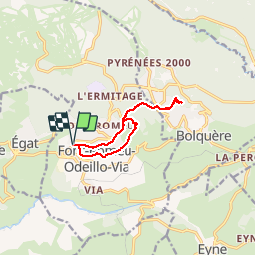
Trail Walking of 9.8 km to be discovered at Occitania, Pyrénées-Orientales, Font-Romeu-Odeillo-Via. This trail is proposed by crijack.
Description
Départ de Val Pyrène par le chemin de petite randonnée, parcours de santé à l'étang du Ticou et retour par la route
Positioning
Country:
France
Region :
Occitania
Department/Province :
Pyrénées-Orientales
Municipality :
Font-Romeu-Odeillo-Via
Location:
Unknown
Start:(Dec)
Start:(UTM)
420609 ; 4705779 (31T) N.
Comments
Trails nearby
![Trail Walking Font-Romeu-Odeillo-Via - Coll del Pam lac des Bouillouses - Photo](https://media.geolcdn.com/t/375/260/ext.jpg?maxdim=2&url=https%3A%2F%2Fservices.sitytrail.com%2FGeolivesWS%2FDownloadMedia.ashx%3FTrailID%3D802013%26Media%3Dfix__20170803141713.jpg)
![Walking Walking](https://static1.geolcdn.com/sitytour/trail-icons/101.png)
Coll del Pam lac des Bouillouses
Walking
Medium
(2)
Font-Romeu-Odeillo-Via,
Occitania,
Pyrénées-Orientales,
France
![](/images/other/stat-length.png)
13.3 km | 19.3 km-effort
4h 10min
![](https://static1.geolcdn.com/siteimages/upload/files/16400158638029165_repeat_loop_refresh_sync_direction_icon.png)
Yes
![Trail Walking Eyne - Eyne,col de Nuria,pic d'Eyne,Torre d'Eyne,Eyne. - Photo](https://media.geolcdn.com/t/375/260/ext.jpg?maxdim=2&url=https%3A%2F%2Fservices.sitytrail.com%2FGeolivesWS%2FDownloadMedia.ashx%3FTrailID%3D530520%26Media%3D20150811115220.jpg)
![Walking Walking](https://static1.geolcdn.com/sitytour/trail-icons/101.png)
Eyne,col de Nuria,pic d'Eyne,Torre d'Eyne,Eyne.
Walking
Very difficult
(1)
Eyne,
Occitania,
Pyrénées-Orientales,
France
![](/images/other/stat-length.png)
24 km | 43 km-effort
8h 44min
![](https://static1.geolcdn.com/siteimages/upload/files/16400158638029165_repeat_loop_refresh_sync_direction_icon.png)
Yes
![Trail Snowshoes Font-Romeu-Odeillo-Via - pic dels moros - Photo](https://media.geolcdn.com/t/375/260/ext.jpg?maxdim=2&url=https%3A%2F%2Fservices.sitytrail.com%2FGeolivesWS%2FDownloadMedia.ashx%3FTrailID%3D509986%26Media%3Dfix__20140323122816.jpg)
![Snowshoes Snowshoes](https://static1.geolcdn.com/sitytour/trail-icons/504.png)
pic dels moros
Snowshoes
Medium
(1)
Font-Romeu-Odeillo-Via,
Occitania,
Pyrénées-Orientales,
France
![](/images/other/stat-length.png)
12.6 km | 19.4 km-effort
4h 46min
![](https://static1.geolcdn.com/siteimages/upload/files/16400158638029165_repeat_loop_refresh_sync_direction_icon.png)
Yes
![Trail Walking Font-Romeu-Odeillo-Via - Font Romeu Egat - Photo](https://media.geolcdn.com/t/375/260/ext.jpg?maxdim=2&url=https%3A%2F%2Fservices.sitytrail.com%2FGeolivesWS%2FDownloadMedia.ashx%3FTrailID%3D555215%26Media%3D20160418074519.jpg)
![Walking Walking](https://static1.geolcdn.com/sitytour/trail-icons/101.png)
Font Romeu Egat
Walking
Medium
(2)
Font-Romeu-Odeillo-Via,
Occitania,
Pyrénées-Orientales,
France
![](/images/other/stat-length.png)
2.5 km | 3.4 km-effort
44min
![](https://static1.geolcdn.com/siteimages/upload/files/16400158638029165_repeat_loop_refresh_sync_direction_icon.png)
Yes
![Trail Snowshoes Font-Romeu-Odeillo-Via - Pic dels Moros avec Pierre - Photo](https://media.geolcdn.com/t/375/260/ext.jpg?maxdim=2&url=https%3A%2F%2Fservices.sitytrail.com%2FGeolivesWS%2FDownloadMedia.ashx%3FTrailID%3D542171%26Media%3Dfix__20160322124727.jpg)
![Snowshoes Snowshoes](https://static1.geolcdn.com/sitytour/trail-icons/504.png)
Pic dels Moros avec Pierre
Snowshoes
Medium
(1)
Font-Romeu-Odeillo-Via,
Occitania,
Pyrénées-Orientales,
France
![](/images/other/stat-length.png)
10.5 km | 15.9 km-effort
4h 4min
![](https://static1.geolcdn.com/siteimages/upload/files/16400158638029165_repeat_loop_refresh_sync_direction_icon.png)
Yes
![Trail Walking Égat - Egat Puig Moro - Photo](https://media.geolcdn.com/t/375/260/ext.jpg?maxdim=2&url=https%3A%2F%2Fservices.sitytrail.com%2FGeolivesWS%2FDownloadMedia.ashx%3FTrailID%3D460362%26Media%3Dfix__20150817141649.jpg)
![Walking Walking](https://static1.geolcdn.com/sitytour/trail-icons/101.png)
Egat Puig Moro
Walking
Medium
(1)
Égat,
Occitania,
Pyrénées-Orientales,
France
![](/images/other/stat-length.png)
13.4 km | 19.3 km-effort
4h 51min
![](https://static1.geolcdn.com/siteimages/upload/files/16400158638029165_repeat_loop_refresh_sync_direction_icon.png)
Yes
![Trail Walking Égat - La croix d'Egat - Photo](https://media.geolcdn.com/t/375/260/ext.jpg?maxdim=2&url=https%3A%2F%2Fservices.sitytrail.com%2FGeolivesWS%2FDownloadMedia.ashx%3FTrailID%3D143230%26Media%3D20120803102022.jpeg)
![Walking Walking](https://static1.geolcdn.com/sitytour/trail-icons/101.png)
La croix d'Egat
Walking
Easy
(1)
Égat,
Occitania,
Pyrénées-Orientales,
France
![](/images/other/stat-length.png)
7.1 km | 10.4 km-effort
2h 2min
![](https://static1.geolcdn.com/siteimages/upload/files/16400158638029165_repeat_loop_refresh_sync_direction_icon.png)
Yes
![Trail Walking Égat - Le Pic dels Moros - Photo](https://media.geolcdn.com/t/375/260/ext.jpg?maxdim=2&url=https%3A%2F%2Fservices.sitytrail.com%2FGeolivesWS%2FDownloadMedia.ashx%3FTrailID%3D108942%26Media%3D2804_1.jpg)
![Walking Walking](https://static1.geolcdn.com/sitytour/trail-icons/101.png)
Le Pic dels Moros
Walking
Difficult
(2)
Égat,
Occitania,
Pyrénées-Orientales,
France
![](/images/other/stat-length.png)
12.1 km | 18.8 km-effort
5h 30min
![](https://static1.geolcdn.com/siteimages/upload/files/16400158638029165_repeat_loop_refresh_sync_direction_icon.png)
Yes
![Trail Mountain bike Font-Romeu-Odeillo-Via - Espace VTT FFC Pyrénées Catalanes - Circuit n° 6 - Forêt d'Egat - Photo](https://media.geolcdn.com/t/375/260/ext.jpg?maxdim=2&url=https%3A%2F%2Fservices.sitytrail.com%2FGeolivesWS%2FDownloadMedia.ashx%3FTrailID%3D102104%26Media%3D2487_1.jpg)
![Mountain bike Mountain bike](https://static1.geolcdn.com/sitytour/trail-icons/202.png)
Espace VTT FFC Pyrénées Catalanes - Circuit n° 6 - Forêt d'Egat
Mountain bike
Medium
(2)
Font-Romeu-Odeillo-Via,
Occitania,
Pyrénées-Orientales,
France
![](/images/other/stat-length.png)
7.6 km | 10.1 km-effort
1h 0min
![](https://static1.geolcdn.com/siteimages/upload/files/16400158638029165_repeat_loop_refresh_sync_direction_icon.png)
Yes