Trail Mountain bike Venasque - La Venasquaise 24-04-2016 - Photo
 Larage
Larage

User

© OpenStreetMap contributors
Length
Length
28 km
Max alt
Max alt
694 m
Uphill gradient
Uphill gradient
884 m
Km-Effort
Km-Effort  
40 km
Min alt
Min alt
181 m
Downhill gradient
Downhill gradient
883 m
Boucle
Boucle
Yes
Creation date :
2016-04-25 00:00:00.0
Updated on :
2016-04-25 00:00:00.0

(0 Reviews)

Mountain bike
Mountain bike
3h36
Difficulty : Difficult

Scan this QR Code to open this trail in the SityTrail application

FREE GPS app for hiking

Logo SityTrail SityTrail

IGN / Geographical institutes

Download SityTrail from the App Store Download SityTrail from Google Play

Logo SityTrail SityTrail World

The world is yours!

Download SityTrail from the App Store Download SityTrail from Google Play Download SityTrail on Huawei AppGallery

About

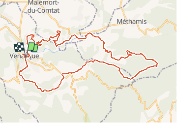
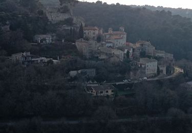
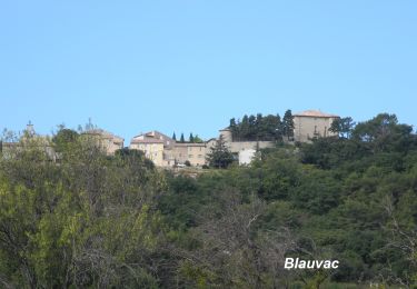
Trail Mountain bike of 28 km to be discovered at Provence-Alpes-Côte d'Azur, Vaucluse, Venasque. This trail is proposed by Larage.

Description

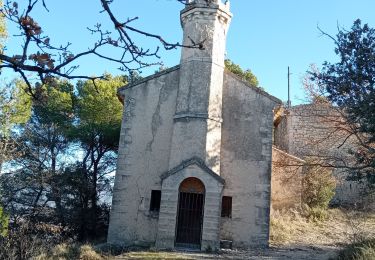
Très bonne rando avec un parcour de 30km au départ de Venasque en passant dans les monts de Vaucluse, a proximiter de Malemort du Comtat, puis retour par Notre Dame de Vie et a travers les fameux champs de cerisiers de Venasque! Sans oublier les ravitos qui furent excéllent et un bon repas à l'arriver! Merci a tout ceux qui ont organiser ceci.

Elevation profile

Positioning

Country:
France
Region :
Provence-Alpes-Côte d'Azur
Department/Province :
Vaucluse
Municipality :
Venasque
Location:
Unknown
Start:(UTM)
672231 ; 4873534 (31T) N.

Trails nearby

Trail Motor La Roque-sur-Pernes - le beaucet  - Photo
Motor
Tabagns84

Motor

Easy
(1)
La Roque-sur-Pernes, Provence-Alpes-Côte d'Azur, Vaucluse, France
8.1 km | 10.8 km-effort
2h 52min
Yes
Trail Walking Malemort-du-Comtat - malemort de Comtat PR19 - Photo
Walking
DoBelle

Walking

Easy
(1)
Malemort-du-Comtat, Provence-Alpes-Côte d'Azur, Vaucluse, France
15.9 km | 20 km-effort
3h 53min
No
Trail Walking Venasque - Venasque - Photo
Walking
dchevrier

Walking

Easy
(3)
Venasque, Provence-Alpes-Côte d'Azur, Vaucluse, France
13.1 km | 19.3 km-effort
4h 10min
Yes
Trail Walking Malemort-du-Comtat - Traversée Malemort Mormoiron - Photo
Walking
GUIDE
supercolas

Walking

Medium
Malemort-du-Comtat, Provence-Alpes-Côte d'Azur, Vaucluse, France
13.1 km | 18.1 km-effort
3h 25min
No
Trail Walking Mazan - Boucle NdA - Photo
Walking
GUIDE
supercolas

Walking

Medium
Mazan, Provence-Alpes-Côte d'Azur, Vaucluse, France
11.6 km | 16.8 km-effort
3h 4min
Yes
Trail Walking Venasque - Combes et forêt de Vénasque  - Photo
Walking
GUIDE
nadinebondoux

Walking

Difficult
Venasque, Provence-Alpes-Côte d'Azur, Vaucluse, France
19.1 km | 28 km-effort
5h 59min
Yes
Trail Walking Le Beaucet - Le beaucet - St gens - le beaucet village et château  - Photo
Walking
GUIDE
stef789

Walking

Easy
Le Beaucet, Provence-Alpes-Côte d'Azur, Vaucluse, France
13 km | 18.6 km-effort
5h 5min
Yes
Trail Walking Le Beaucet - le BEAUCET  SAINT GENS  - Photo
Walking
FLORENSAC

Walking

Difficult
Le Beaucet, Provence-Alpes-Côte d'Azur, Vaucluse, France
10.1 km | 15.6 km-effort
3h 32min
Yes
Trail Walking La Roque-sur-Pernes - La Roque sur Pernes - Photo
Walking
FLORENSAC

Walking

Medium
La Roque-sur-Pernes, Provence-Alpes-Côte d'Azur, Vaucluse, France
13.8 km | 21 km-effort
5h 36min
Yes


Close
My subscriptions