Trail Walking Pézilla-la-Rivière - Autour de Corneille, vers les éoliennes  - Photo

Autour de Corneille, vers les éoliennes

 zazie
zazie

User

© OpenStreetMap contributors
Length
Length
8.7 km
Max alt
Max alt
145 m
Uphill gradient
Uphill gradient
88 m
Km-Effort
Km-Effort  
9.8 km
Min alt
Min alt
77 m
Downhill gradient
Downhill gradient
86 m
Boucle
Boucle
Yes
Creation date :
2016-04-12 00:00:00.0
Updated on :
2016-04-12 00:00:00.0

(0 Reviews)

Walking
Walking
2h09
Difficulty : Difficult

Scan this QR Code to open this trail in the SityTrail application

FREE GPS app for hiking

Logo SityTrail SityTrail

IGN / Geographical institutes

Download SityTrail from the App Store Download SityTrail from Google Play

Logo SityTrail SityTrail World

The world is yours!

Download SityTrail from the App Store Download SityTrail from Google Play Download SityTrail on Huawei AppGallery

About

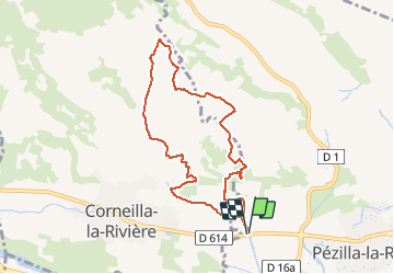
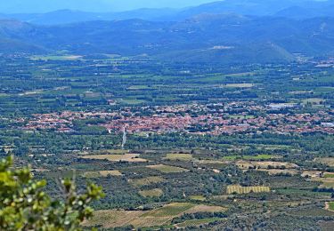
Trail Walking of 8.7 km to be discovered at Occitania, Pyrénées-Orientales, Pézilla-la-Rivière. This trail is proposed by zazie.

Description

Attention, passages délicats dabs la garrigue !

Elevation profile

Positioning

Country:
France
Region :
Occitania
Department/Province :
Pyrénées-Orientales
Municipality :
Pézilla-la-Rivière
Location:
Unknown
Start:(UTM)
479488 ; 4727117 (31T) N.

Trails nearby

Trail On foot Corneilla-la-Rivière - Sentier Lambert Narach - Photo
On foot
PRO

On foot

Easy
Corneilla-la-Rivière, Occitania, Pyrénées-Orientales, France
6.7 km | 11.4 km-effort
2h 35min
No
Trail Walking Corneilla-la-Rivière - 20240316 Corneilla la rivière  - Photo
Walking
ThonyM

Walking

Medium
Corneilla-la-Rivière, Occitania, Pyrénées-Orientales, France
19 km | 28 km-effort
4h 31min
Yes
Trail Running Saint-Féliu-d'Avall - Boucle St Feliu Amont -Ill sur Tête  - Photo
Running
zazie

Running

Medium
(1)
Saint-Féliu-d'Avall, Occitania, Pyrénées-Orientales, France
23 km | 25 km-effort
2h 8min
No
Trail Walking Saint-Féliu-d'Avall - 66 ST-FELIU-D'AVALL, CORNEILLA DE LA RIVIERE, promenade autour de la Têt - Photo
Walking
jeff66

Walking

Easy
Saint-Féliu-d'Avall, Occitania, Pyrénées-Orientales, France
6.6 km | 7 km-effort
1h 16min
Yes
Trail Walking Baixas - 66 VILLENEUVE-LA-RIVIÈRE, promenade entre parcs éoliens et vignobles CALCE - Photo
Walking
jeff66

Walking

Easy
Baixas, Occitania, Pyrénées-Orientales, France
8 km | 8.7 km-effort
1h 33min
Yes
Trail Walking Pézilla-la-Rivière - 66 CORNEILLA-LA-RIVIERE, promenade sur les hauteurs vallonnées, entre vignes et parc éolien  - Photo
Walking
jeff66

Walking

Medium
(1)
Pézilla-la-Rivière, Occitania, Pyrénées-Orientales, France
8.3 km | 9.5 km-effort
1h 31min
Yes
Trail Walking Le Soler - 66 LE SOLER - ST FELIU D'AVALL, promenade le long du Rau du SOLER et de la rivière de CASTELNOU entre canaux et vergers - Photo
Walking
jeff66

Walking

Easy
Le Soler, Occitania, Pyrénées-Orientales, France
9.8 km | 10.4 km-effort
1h 39min
Yes
Trail Walking Le Soler - 66 LE SOLER - TOULOUGES, village, jardins, vergers, canaux et la Basse - Photo
Walking
jeff66

Walking

Medium
Le Soler, Occitania, Pyrénées-Orientales, France
13.5 km | 14.3 km-effort
2h 15min
Yes
Trail Walking Pézilla-la-Rivière - 66 PEZILLA-la-Riviere - VILLENEUVE-la-riviere - LE SOLER - vallée de la TÊT - Photo
Walking
jeff66

Walking

Medium
Pézilla-la-Rivière, Occitania, Pyrénées-Orientales, France
15.9 km | 17.3 km-effort
2h 44min
Yes


Close
My subscriptions