![](/images/other/stat-length.png)
![Trail Walking Rochebaudin - le rocher de la tournelle depuis Rochebaudin - Photo](https://media.geolcdn.com/t/1900/400/ext.pjpeg?maxdim=2&url=https%3A%2F%2Fstatic1.geolcdn.com%2Fsiteimages%2Fupload%2Ffiles%2F1553511878bg_sport_marche.png)
le rocher de la tournelle depuis Rochebaudin
bymarc26
User
![Length](/images/other/stat-length.png)
Length
17.1 km
![Max alt](https://static1.geolcdn.com/siteimages/upload/files/1508320355ic_sort_altitude_max_24dp.png)
Max alt
966 m
![Uphill gradient](https://static1.geolcdn.com/siteimages/upload/files/1508320355ic_sort_den_pos_24dp.png)
Uphill gradient
846 m
![Km-Effort](/images/other/stat-length.png)
Km-Effort
28 km
![Min alt](https://static1.geolcdn.com/siteimages/upload/files/1508320355ic_sort_altitude_min_24dp.png)
Min alt
328 m
![Downhill gradient](https://static1.geolcdn.com/siteimages/upload/files/1508320355ic_sort_den_neg_24dp.png)
Downhill gradient
842 m
![Boucle](https://static1.geolcdn.com/siteimages/upload/files/16400158638029165_repeat_loop_refresh_sync_direction_icon.png)
Boucle
Yes
Creation date :
2016-04-11 00:00:00.0
Updated on :
2016-04-11 00:00:00.0
![Walking](https://static1.geolcdn.com/sitytour/trail-icons/101.png)
6h41
Difficulty : Difficult
![Scan this QR Code to open this trail in the SityTrail application](https://capi.geolives.com/qq0zvz2zws4bq2lad0pu/sitytour/trails/550377/qr.png?size=200)
FREE GPS app for hiking
About
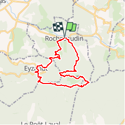
Trail Walking of 17.1 km to be discovered at Auvergne-Rhône-Alpes, Drôme, Rochebaudin. This trail is proposed by bymarc26.
Description
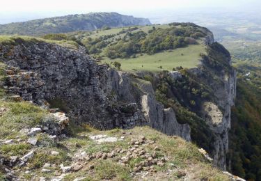
Attention cette randonnée comporte quelques passage difficile; notamment la descente par le trou du furet. Comme le rappelle la pancarte à l'entrée "passage réservé aux randonneurs expérimentés"
Positioning
Country:
France
Region :
Auvergne-Rhône-Alpes
Department/Province :
Drôme
Municipality :
Rochebaudin
Location:
Unknown
Start:(Dec)
Start:(UTM)
661285 ; 4938318 (31T) N.
Comments
Trails nearby
![Trail Walking Pont-de-Barret - Pont-de-Barret 7km5 - Photo](https://media.geolcdn.com/t/375/260/bd4539ba-b505-451b-88b8-8a669ff8e607.jpg&format=jpg&maxdim=2)
![Walking Walking](https://static1.geolcdn.com/sitytour/trail-icons/101.png)
Pont-de-Barret 7km5
Walking
Difficult
(1)
Pont-de-Barret,
Auvergne-Rhône-Alpes,
Drôme,
France
![](/images/other/stat-length.png)
7.5 km | 12.5 km-effort
2h 50min
![](https://static1.geolcdn.com/siteimages/upload/files/16400158638029165_repeat_loop_refresh_sync_direction_icon.png)
Yes
![Trail On foot Eyzahut - SityTrail - Boucle 1 - Photo](https://media.geolcdn.com/t/375/260/18dbfece-5a68-4dfb-9f06-5bb6196c6685.jpg&format=jpg&maxdim=2)
![On foot On foot](https://static1.geolcdn.com/sitytour/trail-icons/100.png)
SityTrail - Boucle 1
On foot
Very difficult
(2)
Eyzahut,
Auvergne-Rhône-Alpes,
Drôme,
France
![](/images/other/stat-length.png)
17.3 km | 31 km-effort
6h 0min
![](https://static1.geolcdn.com/siteimages/upload/files/16400158638029165_repeat_loop_refresh_sync_direction_icon.png)
Yes
![Trail Walking Francillon-sur-Roubion - Balade à francillon sur roubion - description et photos - Photo](https://media.geolcdn.com/t/375/260/ext.jpg?maxdim=2&url=https%3A%2F%2Fservices.sitytrail.com%2FGeolivesWS%2FDownloadMedia.ashx%3FTrailID%3D656838%26Media%3Dfix__20161106144505.jpg)
![Walking Walking](https://static1.geolcdn.com/sitytour/trail-icons/101.png)
Balade à francillon sur roubion - description et photos
Walking
Easy
(1)
Francillon-sur-Roubion,
Auvergne-Rhône-Alpes,
Drôme,
France
![](/images/other/stat-length.png)
5 km | 6.7 km-effort
1h 36min
![](https://static1.geolcdn.com/siteimages/upload/files/16400158638029165_repeat_loop_refresh_sync_direction_icon.png)
Yes
![Trail Walking Dieulefit - 26 dieulefit chap st Maurice vitrouilleres - Photo](https://media.geolcdn.com/t/375/260/9032ba92-359b-417c-8863-3a326ab807ba.jpg&format=jpg&maxdim=2)
![Walking Walking](https://static1.geolcdn.com/sitytour/trail-icons/101.png)
26 dieulefit chap st Maurice vitrouilleres
Walking
Easy
Dieulefit,
Auvergne-Rhône-Alpes,
Drôme,
France
![](/images/other/stat-length.png)
13.8 km | 23 km-effort
6h 17min
![](https://static1.geolcdn.com/siteimages/upload/files/16400158638029165_repeat_loop_refresh_sync_direction_icon.png)
Yes
![Trail Walking Le Poët-Laval - Poët-Laval Les vitrouilléres (La Dame Blanche) 9km. - Photo](https://media.geolcdn.com/t/375/260/aa6f7aee-41bd-433a-b904-1eda7a964ff6.jpg&format=jpg&maxdim=2)
![Walking Walking](https://static1.geolcdn.com/sitytour/trail-icons/101.png)
Poët-Laval Les vitrouilléres (La Dame Blanche) 9km.
Walking
Medium
Le Poët-Laval,
Auvergne-Rhône-Alpes,
Drôme,
France
![](/images/other/stat-length.png)
8.7 km | 11.5 km-effort
2h 37min
![](https://static1.geolcdn.com/siteimages/upload/files/16400158638029165_repeat_loop_refresh_sync_direction_icon.png)
Yes
![Trail Walking Le Poët-Laval - Le Poet Laval : Le Trou du Furet 6km5 - Photo](https://media.geolcdn.com/t/375/260/e856c3d2-cc59-44f2-9430-12ee63613b6b.jpg&format=jpg&maxdim=2)
![Walking Walking](https://static1.geolcdn.com/sitytour/trail-icons/101.png)
Le Poet Laval : Le Trou du Furet 6km5
Walking
Difficult
Le Poët-Laval,
Auvergne-Rhône-Alpes,
Drôme,
France
![](/images/other/stat-length.png)
6.4 km | 12.9 km-effort
2h 55min
![](https://static1.geolcdn.com/siteimages/upload/files/16400158638029165_repeat_loop_refresh_sync_direction_icon.png)
Yes
![Trail Walking Rochebaudin - Rochebaudin-Trou du Furet-Serre Gros 16km - Photo](https://media.geolcdn.com/t/375/260/dc7160ec-c951-47bb-8de8-e15fab760352.jpg&format=jpg&maxdim=2)
![Walking Walking](https://static1.geolcdn.com/sitytour/trail-icons/101.png)
Rochebaudin-Trou du Furet-Serre Gros 16km
Walking
Difficult
Rochebaudin,
Auvergne-Rhône-Alpes,
Drôme,
France
![](/images/other/stat-length.png)
15.8 km | 26 km-effort
5h 0min
![](https://static1.geolcdn.com/siteimages/upload/files/16400158638029165_repeat_loop_refresh_sync_direction_icon.png)
Yes
![Trail Walking Dieulefit - 2022-09-03_11h50m30_Chapelle St Maurice 10km.gpx (3).xml - Photo](https://media.geolcdn.com/t/375/260/70a2cb51-e6fc-4007-ba36-e4a050e05f72.jpg&format=jpg&maxdim=2)
![Walking Walking](https://static1.geolcdn.com/sitytour/trail-icons/101.png)
2022-09-03_11h50m30_Chapelle St Maurice 10km.gpx (3).xml
Walking
Difficult
Dieulefit,
Auvergne-Rhône-Alpes,
Drôme,
France
![](/images/other/stat-length.png)
10 km | 17.1 km-effort
3h 53min
![](https://static1.geolcdn.com/siteimages/upload/files/16400158638029165_repeat_loop_refresh_sync_direction_icon.png)
Yes
![Trail Walking Manas - SityTrail - Puy St Martin La Pigne-Saudon 8,5km - Photo](https://media.geolcdn.com/t/375/260/aabcc6ea-3a3d-45fe-9e4a-f6a7c1e309c7.jpg&format=jpg&maxdim=2)
![Walking Walking](https://static1.geolcdn.com/sitytour/trail-icons/101.png)
SityTrail - Puy St Martin La Pigne-Saudon 8,5km
Walking
Medium
Manas,
Auvergne-Rhône-Alpes,
Drôme,
France
![](/images/other/stat-length.png)
13.9 km | 21 km-effort
4h 30min
![](https://static1.geolcdn.com/siteimages/upload/files/16400158638029165_repeat_loop_refresh_sync_direction_icon.png)
Yes