![](/images/other/stat-length.png)
![Trail Walking Saxon-Sion - Sion - Photo](https://media.geolcdn.com/t/1900/400/ext.pjpeg?maxdim=2&url=https%3A%2F%2Fstatic1.geolcdn.com%2Fsiteimages%2Fupload%2Ffiles%2F1553511878bg_sport_marche.png)
Sion
DanielROLLET
User
![Length](/images/other/stat-length.png)
Length
12.4 km
![Max alt](https://static1.geolcdn.com/siteimages/upload/files/1508320355ic_sort_altitude_max_24dp.png)
Max alt
531 m
![Uphill gradient](https://static1.geolcdn.com/siteimages/upload/files/1508320355ic_sort_den_pos_24dp.png)
Uphill gradient
293 m
![Km-Effort](/images/other/stat-length.png)
Km-Effort
16.3 km
![Min alt](https://static1.geolcdn.com/siteimages/upload/files/1508320355ic_sort_altitude_min_24dp.png)
Min alt
396 m
![Downhill gradient](https://static1.geolcdn.com/siteimages/upload/files/1508320355ic_sort_den_neg_24dp.png)
Downhill gradient
294 m
![Boucle](https://static1.geolcdn.com/siteimages/upload/files/16400158638029165_repeat_loop_refresh_sync_direction_icon.png)
Boucle
Yes
Creation date :
2016-03-31 00:00:00.0
Updated on :
2016-03-31 00:00:00.0
![Walking](https://static1.geolcdn.com/sitytour/trail-icons/101.png)
--
Difficulty : Very easy
![Scan this QR Code to open this trail in the SityTrail application](https://capi.geolives.com/qq0zvz2zws4bq2lad0pu/sitytour/trails/546734/qr.png?size=200)
FREE GPS app for hiking
About
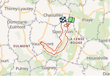
Trail Walking of 12.4 km to be discovered at Grand Est, Meurthe-et-Moselle, Saxon-Sion. This trail is proposed by DanielROLLET.
Description
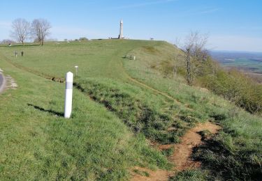
balisage anneaux rouges et anneaux vertsDurée 3h pour 12,3kmDénivelé cumulé 273mParking de la basilique : se diriger le long du parcours sonore et descendre à droite après 100m
Positioning
Country:
France
Region :
Grand Est
Department/Province :
Meurthe-et-Moselle
Municipality :
Saxon-Sion
Location:
Unknown
Start:(Dec)
Start:(UTM)
284338 ; 5368194 (32U) N.
Comments
Trails nearby
![Trail On foot Vaudémont - Circuit Barrès - Brunehaut - Photo](https://media.geolcdn.com/t/375/260/4379cc40-7f33-4534-895d-40998ea52ef9.jpeg&format=jpg&maxdim=2)
![On foot On foot](https://static1.geolcdn.com/sitytour/trail-icons/100.png)
Circuit Barrès - Brunehaut
On foot
Easy
Vaudémont,
Grand Est,
Meurthe-et-Moselle,
France
![](/images/other/stat-length.png)
8.4 km | 10.7 km-effort
2h 26min
![](https://static1.geolcdn.com/siteimages/upload/files/16400158638029165_repeat_loop_refresh_sync_direction_icon.png)
Yes
![Trail Walking Saxon-Sion - Sion - Photo](https://media.geolcdn.com/t/375/260/ext.jpg?maxdim=2&url=https%3A%2F%2Fstatic1.geolcdn.com%2Fsiteimages%2Fupload%2Ffiles%2F1553511878bg_sport_marche.png)
![Walking Walking](https://static1.geolcdn.com/sitytour/trail-icons/101.png)
Sion
Walking
Very easy
(1)
Saxon-Sion,
Grand Est,
Meurthe-et-Moselle,
France
![](/images/other/stat-length.png)
12.5 km | 16.2 km-effort
4h 40min
![](https://static1.geolcdn.com/siteimages/upload/files/16400158638029165_repeat_loop_refresh_sync_direction_icon.png)
Yes
![Trail Walking Praye - PRAYE - LA COLLINE DE SION-VAUDEMONT - Photo](https://media.geolcdn.com/t/375/260/f6dfea2b-18d4-4541-a670-282ca29a8c57.jpg&format=jpg&maxdim=2)
![Walking Walking](https://static1.geolcdn.com/sitytour/trail-icons/101.png)
PRAYE - LA COLLINE DE SION-VAUDEMONT
Walking
Easy
(1)
Praye,
Grand Est,
Meurthe-et-Moselle,
France
![](/images/other/stat-length.png)
16.6 km | 22 km-effort
8h 52min
![](https://static1.geolcdn.com/siteimages/upload/files/16400158638029165_repeat_loop_refresh_sync_direction_icon.png)
Yes
![Trail sport Vaudémont - Vaudemont - Photo](https://media.geolcdn.com/t/375/260/3e0597da-804d-40ff-aac7-534e403227a8.jpg&format=jpg&maxdim=2)
Vaudemont
sport
Very easy
Vaudémont,
Grand Est,
Meurthe-et-Moselle,
France
![](/images/other/stat-length.png)
5 km | 6.4 km-effort
Unknown
![](https://static1.geolcdn.com/siteimages/upload/files/16400158638029165_repeat_loop_refresh_sync_direction_icon.png)
Yes
![Trail Walking Saxon-Sion - sion - Photo](https://media.geolcdn.com/t/375/260/9578318c-4e9b-48e6-b13f-618e356491c1.jpg&format=jpg&maxdim=2)
![Walking Walking](https://static1.geolcdn.com/sitytour/trail-icons/101.png)
sion
Walking
Medium
Saxon-Sion,
Grand Est,
Meurthe-et-Moselle,
France
![](/images/other/stat-length.png)
12.2 km | 16 km-effort
4h 36min
![](https://static1.geolcdn.com/siteimages/upload/files/16400158638029165_repeat_loop_refresh_sync_direction_icon.png)
Yes
![Trail Walking Praye - tour de Sion 54 - Photo](https://media.geolcdn.com/t/375/260/efd9d13b-96a3-4b6c-aa74-e6fa88929e0e.jpg&format=jpg&maxdim=2)
![Walking Walking](https://static1.geolcdn.com/sitytour/trail-icons/101.png)
tour de Sion 54
Walking
Medium
Praye,
Grand Est,
Meurthe-et-Moselle,
France
![](/images/other/stat-length.png)
18.3 km | 25 km-effort
5h 8min
![](https://static1.geolcdn.com/siteimages/upload/files/16400158638029165_repeat_loop_refresh_sync_direction_icon.png)
Yes
![Trail Walking Vaudémont - 2012-01-15 18h02m24 - Photo](https://media.geolcdn.com/t/375/260/ext.jpg?maxdim=2&url=https%3A%2F%2Fservices.sitytrail.com%2FGeolivesWS%2FDownloadMedia.ashx%3FTrailID%3D98704%26Media%3D20120115165929.jpeg)
![Walking Walking](https://static1.geolcdn.com/sitytour/trail-icons/101.png)
2012-01-15 18h02m24
Walking
Easy
Vaudémont,
Grand Est,
Meurthe-et-Moselle,
France
![](/images/other/stat-length.png)
4 km | 4.8 km-effort
1h 4min
![](https://static1.geolcdn.com/siteimages/upload/files/16400158638029165_repeat_loop_refresh_sync_direction_icon.png)
Yes
![Trail Walking Vaudémont - Randoguide - Photo](https://media.geolcdn.com/t/375/260/ext.jpg?maxdim=2&url=https%3A%2F%2Fservices.sitytrail.com%2FGeolivesWS%2FDownloadMedia.ashx%3FTrailID%3D90656%26Media%3D20111106174526.jpeg)
![Walking Walking](https://static1.geolcdn.com/sitytour/trail-icons/101.png)
Randoguide
Walking
Medium
Vaudémont,
Grand Est,
Meurthe-et-Moselle,
France
![](/images/other/stat-length.png)
9.9 km | 12.9 km-effort
2h 45min
![](https://static1.geolcdn.com/siteimages/upload/files/16400158638029165_repeat_loop_refresh_sync_direction_icon.png)
Yes
![Trail Walking Saxon-Sion - Sion - Photo](https://media.geolcdn.com/t/375/260/ext.jpg?maxdim=2&url=https%3A%2F%2Fstatic1.geolcdn.com%2Fsiteimages%2Fupload%2Ffiles%2F1553511878bg_sport_marche.png)
![Walking Walking](https://static1.geolcdn.com/sitytour/trail-icons/101.png)