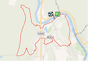
![](/images/other/stat-length.png)
![Trail Walking Vresse-sur-Semois - RF-Na-15-Alle_Petite-boucle - Photo](https://media.geolcdn.com/t/1900/400/ext.pjpeg?maxdim=2&url=https%3A%2F%2Fservices.sitytrail.com%2FGeolivesWS%2FDownloadMedia.ashx%3FTrailID%3D545781%26Media%3Dcddf67a2-2122-4df8-9173-84c1aa8e3608.jpg)
RF-Na-15-Alle_Petite-boucle
GR Rando
Randonnez sur et autour des GR ® wallons (Sentiers de Grande Randonnée). PRO
![Length](/images/other/stat-length.png)
![Max alt](https://static1.geolcdn.com/siteimages/upload/files/1508320355ic_sort_altitude_max_24dp.png)
![Uphill gradient](https://static1.geolcdn.com/siteimages/upload/files/1508320355ic_sort_den_pos_24dp.png)
![Km-Effort](/images/other/stat-length.png)
![Min alt](https://static1.geolcdn.com/siteimages/upload/files/1508320355ic_sort_altitude_min_24dp.png)
![Downhill gradient](https://static1.geolcdn.com/siteimages/upload/files/1508320355ic_sort_den_neg_24dp.png)
![Boucle](https://static1.geolcdn.com/siteimages/upload/files/16400158638029165_repeat_loop_refresh_sync_direction_icon.png)
![Walking](https://static1.geolcdn.com/sitytour/trail-icons/101.png)
2h00
Difficulty : Medium
![Scan this QR Code to open this trail in the SityTrail application](https://capi.geolives.com/qq0zvz2zws4bq2lad0pu/sitytour/trails/545781/qr.png?size=200)
FREE GPS app for hiking
About
Trail Walking of 6.3 km to be discovered at Wallonia, Namur, Vresse-sur-Semois. This trail is proposed by GR Rando.
Description
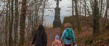
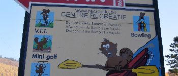
Récréons-nous à Alle-sur-Semois !
Dans quel type de paysage notre famille randonne-t-elle ?
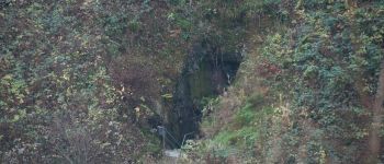
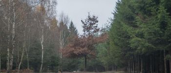
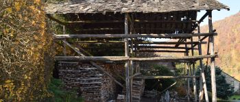
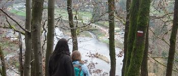
Qui dit Semois pense à une vallée exceptionnelle où la rivière dessine d’innombrables méandres. Notre famille Rando y crapahute sur ses versants. Elle découvre le charmant village de Alle. Elle traverse aussi une forêt typique de l’Ardenne avec ses essences traditionnelles de mélèzes, épicéas, bouleaux, chênes, hêtres…
Quelle difficulté pour notre famille Rando?
Cette randonnée est très sportive, sans doute la plus sportive de toutes les balades proposées dans ce topo-guide. Grimpettes escarpées et descentes abruptes sont au menu du jour !
Combien de kilomètres ?
6,5 km pour la petite boucle.
Sur quel GR randonne-t-elle ?
Sur deux tronçons (au départ et à l’arrivée) du GR 16 « Sentier de la Semois ». Ce GR démarre à Arlon à l’endroit de la source de la Semois. Il suit les méandres de la rivière, qui devient Semoy en France. Ce cours d’eau se jette dans la Meuse à Monthermé, là où le GR 16 s’arrête aussi.
Où démarre-t-elle ?
Du parking de Récréalle.
Comment y arrive-t-elle ?
Par la route N95 Dinant - Bouillon. Prendre la direction de Vresse-sur-Semois et de Alle, après le village de Bièvre, via la N914 par exemple.
Que découvre-t-elle aujourd’hui ?
Plutôt qu’une découverte, c’est une longue récréation que s’offre aujourd’hui la famille Rando puisqu’il y a de multiples possibilités de se distraire au centre récréatif Récréalle.
Quelle est la carte IGN de référence ?
Carte IGN au 1:20 000, 63/7-8 « Vresse-sur-Semois ».
Points of interest
Positioning
Comments
Trails nearby
![Trail Walking Bouillon - RB-Lu-12 - Premier contact avec la Semois au Tombeau du Géant - Photo](https://media.geolcdn.com/t/375/260/ext.jpg?maxdim=2&url=https%3A%2F%2Fservices.sitytrail.com%2FGeolivesWS%2FDownloadMedia.ashx%3FTrailID%3D179617%26Media%3Dd1ff11f2-43fb-4a27-8679-182dbfec36f0.jpg)
![Walking Walking](https://static1.geolcdn.com/sitytour/trail-icons/101.png)
Walking
![](/images/other/stat-length.png)
![](https://static1.geolcdn.com/siteimages/upload/files/16400158638029165_repeat_loop_refresh_sync_direction_icon.png)
![Walking Walking](https://static1.geolcdn.com/sitytour/trail-icons/101.png)
Walking
![](/images/other/stat-length.png)
![](https://static1.geolcdn.com/siteimages/upload/files/16400158638029165_repeat_loop_refresh_sync_direction_icon.png)
![Walking Walking](https://static1.geolcdn.com/sitytour/trail-icons/101.png)
Walking
![](/images/other/stat-length.png)
![](https://static1.geolcdn.com/siteimages/upload/files/16400158638029165_repeat_loop_refresh_sync_direction_icon.png)
![Trail Walking Vresse-sur-Semois - RB-Na-09 Variante estivale - L Ardenne des eaux vives - Photo](https://media.geolcdn.com/t/375/260/ext.jpg?maxdim=2&url=https%3A%2F%2Fservices.sitytrail.com%2FGeolivesWS%2FDownloadMedia.ashx%3FTrailID%3D794164%26Media%3D60b701e1-87e7-4c45-96c1-6064d8879e37.jpg)
![Walking Walking](https://static1.geolcdn.com/sitytour/trail-icons/101.png)
Walking
![](/images/other/stat-length.png)
![](https://static1.geolcdn.com/siteimages/upload/files/16400158638029165_repeat_loop_refresh_sync_direction_icon.png)
![Trail Walking Vresse-sur-Semois - RB-Na-09 Raccourci - L Ardenne des eaux vives - Photo](https://media.geolcdn.com/t/375/260/ext.jpg?maxdim=2&url=https%3A%2F%2Fservices.sitytrail.com%2FGeolivesWS%2FDownloadMedia.ashx%3FTrailID%3D262313%26Media%3D60b701e1-87e7-4c45-96c1-6064d8879e37.jpg)
![Walking Walking](https://static1.geolcdn.com/sitytour/trail-icons/101.png)
Walking
![](/images/other/stat-length.png)
![](https://static1.geolcdn.com/siteimages/upload/files/16400158638029165_repeat_loop_refresh_sync_direction_icon.png)
![Trail Walking Vresse-sur-Semois - RB-Na-09 L'Ardenne des eaux vives - Photo](https://media.geolcdn.com/t/375/260/ext.jpg?maxdim=2&url=https%3A%2F%2Fservices.sitytrail.com%2FGeolivesWS%2FDownloadMedia.ashx%3FTrailID%3D260987%26Media%3Db97841e8-b1a3-4e80-a9b6-aaa2b671bafd.jpg)
![Walking Walking](https://static1.geolcdn.com/sitytour/trail-icons/101.png)
Walking
![](/images/other/stat-length.png)
![](https://static1.geolcdn.com/siteimages/upload/files/16400158638029165_repeat_loop_refresh_sync_direction_icon.png)
![Trail Walking Vresse-sur-Semois - La Semois. Natura 2000, des sites qui valent le détour. Na3 - Photo](https://media.geolcdn.com/t/375/260/ext.jpg?maxdim=2&url=https%3A%2F%2Fservices.sitytrail.com%2FGeolivesWS%2FDownloadMedia.ashx%3FTrailID%3D163715%26Media%3Dda40f5b3-1e4b-4509-ae3e-d9dafa1466cc.JPG)
![Walking Walking](https://static1.geolcdn.com/sitytour/trail-icons/101.png)
Walking
![](/images/other/stat-length.png)
![](https://static1.geolcdn.com/siteimages/upload/files/16400158638029165_repeat_loop_refresh_sync_direction_icon.png)
![Trail Walking Vresse-sur-Semois - Vresse-sur-Semois. Natura 2000, des fiches qui valent le détour ! Na1 - Photo](https://media.geolcdn.com/t/375/260/ext.jpg?maxdim=2&url=https%3A%2F%2Fservices.sitytrail.com%2FGeolivesWS%2FDownloadMedia.ashx%3FTrailID%3D161419%26Media%3D7f9dfac9-cf3f-4279-ae43-0aba8e08a963.JPG)
![Walking Walking](https://static1.geolcdn.com/sitytour/trail-icons/101.png)
Walking
![](/images/other/stat-length.png)
![](https://static1.geolcdn.com/siteimages/upload/files/16400158638029165_repeat_loop_refresh_sync_direction_icon.png)
![Trail Walking Bouillon - De Poupehan à Frahan par le sentier des crêtes - Photo](https://media.geolcdn.com/t/375/260/ext.jpg?maxdim=2&url=https%3A%2F%2Fservices.sitytrail.com%2FGeolivesWS%2FDownloadMedia.ashx%3FTrailID%3D138478%26Media%3Db86d13b9-d40b-4a52-ab60-15a552c97303.JPG)
![Walking Walking](https://static1.geolcdn.com/sitytour/trail-icons/101.png)
Walking
![](/images/other/stat-length.png)
![](https://static1.geolcdn.com/siteimages/upload/files/16400158638029165_repeat_loop_refresh_sync_direction_icon.png)