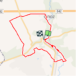
![](/images/other/stat-length.png)
![Trail Walking Jemeppe-sur-Sambre - RF-Na-01-Onoz_Grande-boucle - Photo](https://media.geolcdn.com/t/1900/400/ext.pjpeg?maxdim=2&url=https%3A%2F%2Fservices.sitytrail.com%2FGeolivesWS%2FDownloadMedia.ashx%3FTrailID%3D545736%26Media%3Dca5596bc-2473-4f40-bb0a-21932020469e.jpg)
RF-Na-01-Onoz_Grande-boucle
GR Rando
Randonnez sur et autour des GR ® wallons (Sentiers de Grande Randonnée). PRO
![Length](/images/other/stat-length.png)
![Max alt](https://static1.geolcdn.com/siteimages/upload/files/1508320355ic_sort_altitude_max_24dp.png)
![Uphill gradient](https://static1.geolcdn.com/siteimages/upload/files/1508320355ic_sort_den_pos_24dp.png)
![Km-Effort](/images/other/stat-length.png)
![Min alt](https://static1.geolcdn.com/siteimages/upload/files/1508320355ic_sort_altitude_min_24dp.png)
![Downhill gradient](https://static1.geolcdn.com/siteimages/upload/files/1508320355ic_sort_den_neg_24dp.png)
![Boucle](https://static1.geolcdn.com/siteimages/upload/files/16400158638029165_repeat_loop_refresh_sync_direction_icon.png)
![Walking](https://static1.geolcdn.com/sitytour/trail-icons/101.png)
2h19
Difficulty : Medium
![Scan this QR Code to open this trail in the SityTrail application](https://capi.geolives.com/qq0zvz2zws4bq2lad0pu/sitytour/trails/545736/qr.png?size=200)
FREE GPS app for hiking
About
Trail Walking of 8.8 km to be discovered at Wallonia, Namur, Jemeppe-sur-Sambre. This trail is proposed by GR Rando.
Description
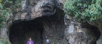
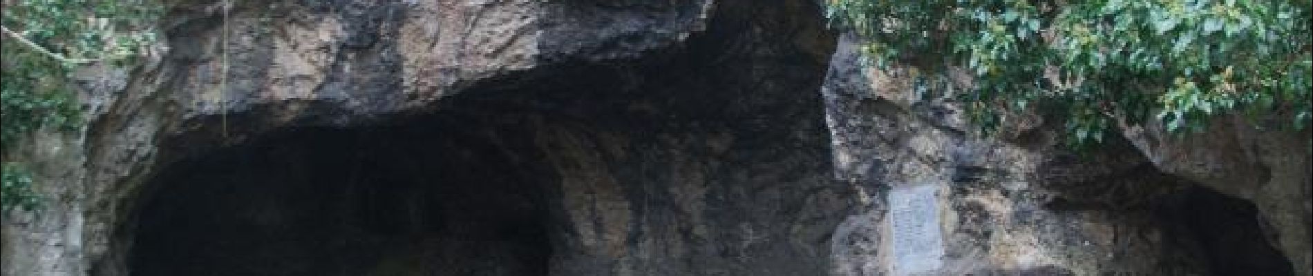
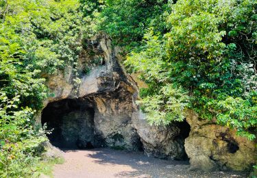
Sur les traces de Spyrou, l'Homme de Spy
Cette randonnée est déconseillée durant les périodes de fortes pluies ou par temps de gros orages. La montée des eaux pourrait empêcher un passage le long de l’Orneau.
Dans quel type de paysage notre famille randonne-t-elle ?
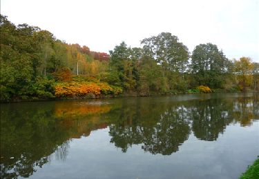
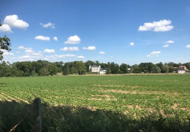
Notre famille Rando découvre aujourd'hui une charmante petite rivière, l'Orneau. Elle la suit dès le départ, l’abandonne quelques kilomètres et la retrouve dans le dernier tronçon de la balade. L’Orneau prend sa source à Meux et se jette dans la Sambre à Jemeppe-sur-Sambre.
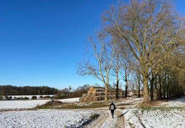
Hormis le massif boisé où a vécu Spyrou, cette randonnée parcourt la campagne des environs d'Onoz.
Quelle difficulté ?
Parcours aisé.
Combien de kilomètres ?
La grande boucle propose 8,9 km.
Quel GR suit-elle ?
Notre famille Rando emprunte un tronçon du GR 126 qui relie Brussegem à Membre-sur-Semois en passant par Bruxelles, Namur, Dinant et Houyet.
Où démarre-t-elle ?
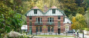
Du parking à côté de l'EHoS (Espace de l’Homme de Spy) d'Onoz.
Comment y arrive-t-elle ?
Adresse : EHoS – route d'Eghezée, 301-303 – 5190 - ONOZ
Par la A15 (autoroute de Wallonie), sortie 13 à Spy, prendre la N912 jusqu’à Onoz
Que découvre-t-elle aujourd’hui ?
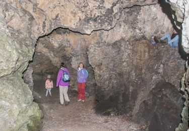
Au cours de la balade, la visite de la grotte de l'Homme de Spy est gratuite. Sa maison reste ouverte 24 heures sur 24. Comme les pièces ne sont pas éclairées, il est conseillé de se munir d’une lampe de poche. Au retour de la balade, pour en savoir plus sur Spyrou, l'Homme de Spy, une visite s’impose au centre d'interprétation de l'EHoS (Espace de l'Homme de Spy).
Quelle est la carte IGN de référence ?
Carte IGN au 1 : 20 000, 47/1-2 « Sombreffe – Jemeppe-sur-Sambre ».
Transports en commun ?
Au départ de la gare de Gembloux (ligne Bruxelles - Namur), prendre le bus 347A Gembloux - Saint- Martin - Tongrinnes - Onoz. S’informer des horaires auprès des TEC Namur-Luxembourg, tél. 081 720 811.
Positioning
Comments
Trails nearby
![Trail Walking Jemeppe-sur-Sambre - RF-Na-01-Onoz_Petite-boucle - Photo](https://media.geolcdn.com/t/375/260/ext.jpg?maxdim=2&url=https%3A%2F%2Fservices.sitytrail.com%2FGeolivesWS%2FDownloadMedia.ashx%3FTrailID%3D545735%26Media%3Df68c7b52-4432-4018-b01d-0bb04e06ad16.jpg)
![Walking Walking](https://static1.geolcdn.com/sitytour/trail-icons/101.png)
Walking
![](/images/other/stat-length.png)
![](https://static1.geolcdn.com/siteimages/upload/files/16400158638029165_repeat_loop_refresh_sync_direction_icon.png)
![Trail Walking Floreffe - Promenade vers Soye par bois et champs - Photo](https://media.geolcdn.com/t/375/260/ext.jpg?maxdim=2&url=https%3A%2F%2Fstatic1.geolcdn.com%2Fsiteimages%2Fupload%2Ffiles%2F1553511878bg_sport_marche.png)
![Walking Walking](https://static1.geolcdn.com/sitytour/trail-icons/101.png)
Walking
![](/images/other/stat-length.png)
![](https://static1.geolcdn.com/siteimages/upload/files/16400158638029165_repeat_loop_refresh_sync_direction_icon.png)
![Trail Walking Jemeppe-sur-Sambre - De Balâtre à Tongrinne par la vallée de la Ligne - Photo](https://media.geolcdn.com/t/375/260/ext.jpg?maxdim=2&url=https%3A%2F%2Fservices.sitytrail.com%2FGeolivesWS%2FDownloadMedia.ashx%3FTrailID%3D95534%26Media%3De2db5dc2-0ab1-4cda-b9fd-3c87611cc9a3.jpg)
![Walking Walking](https://static1.geolcdn.com/sitytour/trail-icons/101.png)
Walking
![](/images/other/stat-length.png)
![](https://static1.geolcdn.com/siteimages/upload/files/16400158638029165_repeat_loop_refresh_sync_direction_icon.png)
![Trail Walking Sambreville - Balade à Sambreville - Auvelais - Photo](https://media.geolcdn.com/t/375/260/ext.jpg?maxdim=2&url=https%3A%2F%2Fservices.sitytrail.com%2FGeolivesWS%2FDownloadMedia.ashx%3FTrailID%3D90120%26Media%3D9923b524-2686-4b8f-a3af-4a51a0dec2b6.jpg)
![Walking Walking](https://static1.geolcdn.com/sitytour/trail-icons/101.png)
Walking
![](/images/other/stat-length.png)
![](https://static1.geolcdn.com/siteimages/upload/files/16400158638029165_repeat_loop_refresh_sync_direction_icon.png)
![Trail Walking Jemeppe-sur-Sambre - La petite boucle de Onoz - Photo](https://media.geolcdn.com/t/375/260/728a8926-dea5-48ea-8a91-8a3e4029625e.jpg&format=jpg&maxdim=2)
![Walking Walking](https://static1.geolcdn.com/sitytour/trail-icons/101.png)
Walking
![](/images/other/stat-length.png)
![](https://static1.geolcdn.com/siteimages/upload/files/16400158638029165_repeat_loop_refresh_sync_direction_icon.png)
![Trail On foot Jemeppe-sur-Sambre - Cirkwi-Sur_les_traces_de_l_Homme_de_Spy_-_tour_complet - Photo](https://media.geolcdn.com/t/375/260/0d4612b7-1403-4944-8642-8449664fec59.jpeg&format=jpg&maxdim=2)
![On foot On foot](https://static1.geolcdn.com/sitytour/trail-icons/100.png)
On foot
![](/images/other/stat-length.png)
![](https://static1.geolcdn.com/siteimages/upload/files/16400158638029165_repeat_loop_refresh_sync_direction_icon.png)
![Walking Walking](https://static1.geolcdn.com/sitytour/trail-icons/101.png)
Walking
![](/images/other/stat-length.png)
![](https://static1.geolcdn.com/siteimages/upload/files/16400158638029165_repeat_loop_refresh_sync_direction_icon.png)
![Trail Walking Floreffe - Franiere - Promenade au bois de Roly - Photo](https://media.geolcdn.com/t/375/260/ext.jpg?maxdim=2&url=https%3A%2F%2Fstatic1.geolcdn.com%2Fsiteimages%2Fupload%2Ffiles%2F1553511878bg_sport_marche.png)
![Walking Walking](https://static1.geolcdn.com/sitytour/trail-icons/101.png)
Walking
![](/images/other/stat-length.png)
![](https://static1.geolcdn.com/siteimages/upload/files/16400158638029165_repeat_loop_refresh_sync_direction_icon.png)
![Trail Mountain bike Jemeppe-sur-Sambre - O2bikers_126_spy - Photo](https://media.geolcdn.com/t/375/260/ext.jpg?maxdim=2&url=https%3A%2F%2Fstatic1.geolcdn.com%2Fsiteimages%2Fupload%2Ffiles%2F1524743154velo.jpg)
![Mountain bike Mountain bike](https://static1.geolcdn.com/sitytour/trail-icons/202.png)
Mountain bike
![](/images/other/stat-length.png)
![](https://static1.geolcdn.com/siteimages/upload/files/16400158638029165_repeat_loop_refresh_sync_direction_icon.png)
top
Juste un peu trop proche de l’autoroute
très sympa et beaux sous sous-bois de narcisses en ce 2 mars.
Très peu de routes bitumées. Parking aisé au départ de la promenade.