![](/images/other/stat-length.png)
![Trail Walking Buxières-sous-les-Côtes - Menhir de Damechonne - Photo](https://media.geolcdn.com/t/1900/400/ext.pjpeg?maxdim=2&url=https%3A%2F%2Fstatic1.geolcdn.com%2Fsiteimages%2Fupload%2Ffiles%2F1553511878bg_sport_marche.png)
Menhir de Damechonne
kikkko
User
![Length](/images/other/stat-length.png)
Length
8 km
![Max alt](https://static1.geolcdn.com/siteimages/upload/files/1508320355ic_sort_altitude_max_24dp.png)
Max alt
399 m
![Uphill gradient](https://static1.geolcdn.com/siteimages/upload/files/1508320355ic_sort_den_pos_24dp.png)
Uphill gradient
176 m
![Km-Effort](/images/other/stat-length.png)
Km-Effort
10.3 km
![Min alt](https://static1.geolcdn.com/siteimages/upload/files/1508320355ic_sort_altitude_min_24dp.png)
Min alt
271 m
![Downhill gradient](https://static1.geolcdn.com/siteimages/upload/files/1508320355ic_sort_den_neg_24dp.png)
Downhill gradient
174 m
![Boucle](https://static1.geolcdn.com/siteimages/upload/files/16400158638029165_repeat_loop_refresh_sync_direction_icon.png)
Boucle
Yes
Creation date :
2016-03-25 00:00:00.0
Updated on :
2016-03-25 00:00:00.0
![Walking](https://static1.geolcdn.com/sitytour/trail-icons/101.png)
2h24
Difficulty : Easy
![Scan this QR Code to open this trail in the SityTrail application](https://capi.geolives.com/qq0zvz2zws4bq2lad0pu/sitytour/trails/542735/qr.png?size=200)
FREE GPS app for hiking
About
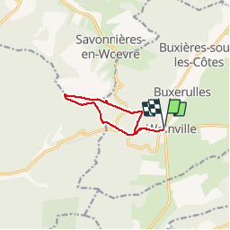
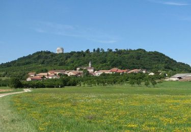
Trail Walking of 8 km to be discovered at Grand Est, Meuse, Buxières-sous-les-Côtes. This trail is proposed by kikkko.
Description
Agréable randonnée sous bois avec en chemin un autel allemand et le fameux menhir!
Très bien balisé par les amis des Côtes (rectangle vert)
Positioning
Country:
France
Region :
Grand Est
Department/Province :
Meuse
Municipality :
Buxières-sous-les-Côtes
Location:
Unknown
Start:(Dec)
Start:(UTM)
694908 ; 5419419 (31U) N.
Comments
Trails nearby
![Trail Mountain bike Heudicourt-sous-les-Côtes - tour lac de la Madine - Photo](https://media.geolcdn.com/t/375/260/ext.jpg?maxdim=2&url=https%3A%2F%2Fstatic1.geolcdn.com%2Fsiteimages%2Fupload%2Ffiles%2F1524743154velo.jpg)
![Mountain bike Mountain bike](https://static1.geolcdn.com/sitytour/trail-icons/202.png)
tour lac de la Madine
Mountain bike
Easy
(1)
Heudicourt-sous-les-Côtes,
Grand Est,
Meuse,
France
![](/images/other/stat-length.png)
18.1 km | 20 km-effort
1h 15min
![](https://static1.geolcdn.com/siteimages/upload/files/16400158638029165_repeat_loop_refresh_sync_direction_icon.png)
Yes
![Trail Walking Buxières-sous-les-Côtes - circuit 14.18 - Photo](https://media.geolcdn.com/t/375/260/a59da31f-7f67-4545-83f8-02a56fd9d3c3.jpg&format=jpg&maxdim=2)
![Walking Walking](https://static1.geolcdn.com/sitytour/trail-icons/101.png)
circuit 14.18
Walking
Medium
Buxières-sous-les-Côtes,
Grand Est,
Meuse,
France
![](/images/other/stat-length.png)
9 km | 11.6 km-effort
3h 12min
![](https://static1.geolcdn.com/siteimages/upload/files/16400158638029165_repeat_loop_refresh_sync_direction_icon.png)
Yes
![Trail Walking Buxières-sous-les-Côtes - Buxieres sous les côtes - Photo](https://media.geolcdn.com/t/375/260/ff501f7b-d90c-4b9b-86e9-2b8cc4dea613.jpeg&format=jpg&maxdim=2)
![Walking Walking](https://static1.geolcdn.com/sitytour/trail-icons/101.png)
Buxieres sous les côtes
Walking
Difficult
Buxières-sous-les-Côtes,
Grand Est,
Meuse,
France
![](/images/other/stat-length.png)
11.9 km | 15.3 km-effort
2h 6min
![](https://static1.geolcdn.com/siteimages/upload/files/16400158638029165_repeat_loop_refresh_sync_direction_icon.png)
No
![Trail Walking Heudicourt-sous-les-Côtes - madine heudicourt - Photo](https://media.geolcdn.com/t/375/260/5b4c8aca-6394-447a-a3ac-76221db7278d.jpg&format=jpg&maxdim=2)
![Walking Walking](https://static1.geolcdn.com/sitytour/trail-icons/101.png)
madine heudicourt
Walking
Very easy
Heudicourt-sous-les-Côtes,
Grand Est,
Meuse,
France
![](/images/other/stat-length.png)
3.5 km | 3.7 km-effort
51min
![](https://static1.geolcdn.com/siteimages/upload/files/16400158638029165_repeat_loop_refresh_sync_direction_icon.png)
No
![Trail Walking Heudicourt-sous-les-Côtes - Lac de Madine - Heudicourt - Photo](https://media.geolcdn.com/t/375/260/ext.jpg?maxdim=2&url=https%3A%2F%2Fservices.sitytrail.com%2FGeolivesWS%2FDownloadMedia.ashx%3FTrailID%3D214995%26Media%3D15567_2.jpg)
![Walking Walking](https://static1.geolcdn.com/sitytour/trail-icons/101.png)
Lac de Madine - Heudicourt
Walking
Medium
(1)
Heudicourt-sous-les-Côtes,
Grand Est,
Meuse,
France
![](/images/other/stat-length.png)
18.4 km | 21 km-effort
4h 30min
![](https://static1.geolcdn.com/siteimages/upload/files/16400158638029165_repeat_loop_refresh_sync_direction_icon.png)
Yes
![Trail Walking Buxières-sous-les-Côtes - Petite promenade à Woinville - Photo](https://media.geolcdn.com/t/375/260/ext.jpg?maxdim=2&url=https%3A%2F%2Fservices.sitytrail.com%2FGeolivesWS%2FDownloadMedia.ashx%3FTrailID%3D109158%26Media%3D3201_1.jpg)
![Walking Walking](https://static1.geolcdn.com/sitytour/trail-icons/101.png)
Petite promenade à Woinville
Walking
Medium
Buxières-sous-les-Côtes,
Grand Est,
Meuse,
France
![](/images/other/stat-length.png)
3.1 km | 4.2 km-effort
1h 10min
![](https://static1.geolcdn.com/siteimages/upload/files/16400158638029165_repeat_loop_refresh_sync_direction_icon.png)
Yes
![Trail On foot Buxières-sous-les-Côtes - woinville 20.10.2024 - Photo](https://media.geolcdn.com/t/375/260/ext.jpg?maxdim=2&url=https%3A%2F%2Fstatic1.geolcdn.com%2Fsiteimages%2Fupload%2Ffiles%2F1545311037marcheuse_200dpi.jpg)
![On foot On foot](https://static1.geolcdn.com/sitytour/trail-icons/100.png)
woinville 20.10.2024
On foot
Easy
Buxières-sous-les-Côtes,
Grand Est,
Meuse,
France
![](/images/other/stat-length.png)
5.3 km | 7.3 km-effort
1h 39min
![](https://static1.geolcdn.com/siteimages/upload/files/16400158638029165_repeat_loop_refresh_sync_direction_icon.png)
Yes
![Trail On foot Buxières-sous-les-Côtes - buxieres 19.10.2024 - Photo](https://media.geolcdn.com/t/375/260/ext.jpg?maxdim=2&url=https%3A%2F%2Fstatic1.geolcdn.com%2Fsiteimages%2Fupload%2Ffiles%2F1545311037marcheuse_200dpi.jpg)
![On foot On foot](https://static1.geolcdn.com/sitytour/trail-icons/100.png)
buxieres 19.10.2024
On foot
Easy
Buxières-sous-les-Côtes,
Grand Est,
Meuse,
France
![](/images/other/stat-length.png)
5.2 km | 7.5 km-effort
1h 42min
![](https://static1.geolcdn.com/siteimages/upload/files/16400158638029165_repeat_loop_refresh_sync_direction_icon.png)
Yes
![Trail Walking Montsec - Montsec (Lac de Madine) 20 560m +233m-19999514 - Photo](https://media.geolcdn.com/t/375/260/ext.jpg?maxdim=2&url=https%3A%2F%2Fstatic1.geolcdn.com%2Fsiteimages%2Fupload%2Ffiles%2F1553511878bg_sport_marche.png)
![Walking Walking](https://static1.geolcdn.com/sitytour/trail-icons/101.png)
Montsec (Lac de Madine) 20 560m +233m-19999514
Walking
Medium
Montsec,
Grand Est,
Meuse,
France
![](/images/other/stat-length.png)
21 km | 24 km-effort
5h 20min
![](https://static1.geolcdn.com/siteimages/upload/files/16400158638029165_repeat_loop_refresh_sync_direction_icon.png)
Yes