Trail Cycle Châtenay - ardèche 2014_backup - Photo
© OpenStreetMap contributors
Length
Length
230 km
Max alt
Max alt
1178 m
Uphill gradient
Uphill gradient
3414 m
Km-Effort
Km-Effort  
275 km
Min alt
Min alt
260 m
Downhill gradient
Downhill gradient
3108 m
Boucle
Boucle
No
Creation date :
2016-04-11 00:00:00.0
Updated on :
2016-04-11 00:00:00.0

(0 Reviews)

Cycle
Cycle
17h40
Difficulty : Very difficult

Scan this QR Code to open this trail in the SityTrail application

FREE GPS app for hiking

Logo SityTrail SityTrail

IGN / Geographical institutes

Download SityTrail from the App Store Download SityTrail from Google Play

Logo SityTrail SityTrail World

The world is yours!

Download SityTrail from the App Store Download SityTrail from Google Play Download SityTrail on Huawei AppGallery

About

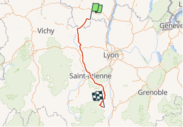
Trail Cycle of 230 km to be discovered at Bourgogne-Franche-Comté, Saône-et-Loire, Châtenay. This trail is proposed by Moonslepaysans.

Description

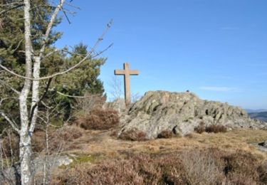
Châtenay alboussière dans la journée avec montée du col de vendrange et du col de la république

Elevation profile

Positioning

Country:
France
Region :
Bourgogne-Franche-Comté
Department/Province :
Saône-et-Loire
Municipality :
Châtenay
Location:
Unknown
Start:(UTM)
606600 ; 5127338 (31T) N.

Trails nearby

Trail Walking Gibles - GIBLES ET SA CAMPAGNE - Photo
Walking
Georgesferrier

Walking

Medium
Gibles, Bourgogne-Franche-Comté, Saône-et-Loire, France
6.4 km | 7.7 km-effort
1h 52min
Yes
Trail On foot Aigueperse - Circuit d'Aigueperse - Photo
On foot
GUIDE+

On foot

Medium
Aigueperse, Auvergne-Rhône-Alpes, Rhône, France
20 km | 29 km-effort
6h 34min
Yes
Trail Mountain bike Varennes-sous-Dun - Marche de Varenne Sous Dun - Photo
Mountain bike
balli51

Mountain bike

Medium
Varennes-sous-Dun, Bourgogne-Franche-Comté, Saône-et-Loire, France
24 km | 33 km-effort
2h 7min
Yes
Trail Walking Saint-Racho - Chassigny 1 - Photo
Walking
COLLOMB69

Walking

Difficult
Saint-Racho, Bourgogne-Franche-Comté, Saône-et-Loire, France
15.2 km | 23 km-effort
4h 26min
Yes
Trail Walking Aigueperse - Circuit d'Aigueperse - Photo
Walking
tracegps

Walking

Difficult
Aigueperse, Auvergne-Rhône-Alpes, Rhône, France
21 km | 29 km-effort
6h 30min
Yes
Trail Walking Saint-Racho - saint racho - Photo
Walking
Pierre Burthier

Walking

Difficult
(1)
Saint-Racho, Bourgogne-Franche-Comté, Saône-et-Loire, France
10.1 km | 14.2 km-effort
3h 14min
Yes
Trail Walking Bois-Sainte-Marie - bois sainte marie R3  - Photo
Walking
reuniona7

Walking

Medium
Bois-Sainte-Marie, Bourgogne-Franche-Comté, Saône-et-Loire, France
7.7 km | 9.5 km-effort
2h 9min
Yes
Trail Coupling Gibles - Gibles equestre 202z - Photo
Coupling
labarge

Coupling

Medium
Gibles, Bourgogne-Franche-Comté, Saône-et-Loire, France
21 km | 27 km-effort
4h 22min
Yes
Trail On foot Gibles - gibles - Photo
On foot
tomalilou

On foot

Easy
Gibles, Bourgogne-Franche-Comté, Saône-et-Loire, France
13.5 km | 17.3 km-effort
3h 56min
Yes


Close
My subscriptions