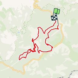
![](/images/other/stat-length.png)
![Trail Walking Irun - AIAKO II - Photo](https://media.geolcdn.com/t/1900/400/ext.pjpeg?maxdim=2&url=https%3A%2F%2Fservices.sitytrail.com%2FGeolivesWS%2FDownloadMedia.ashx%3FTrailID%3D531054%26Media%3Dfix__20160226114401.jpg)
AIAKO II
DECHAMPD
User
![Length](/images/other/stat-length.png)
![Max alt](https://static1.geolcdn.com/siteimages/upload/files/1508320355ic_sort_altitude_max_24dp.png)
![Uphill gradient](https://static1.geolcdn.com/siteimages/upload/files/1508320355ic_sort_den_pos_24dp.png)
![Km-Effort](/images/other/stat-length.png)
![Min alt](https://static1.geolcdn.com/siteimages/upload/files/1508320355ic_sort_altitude_min_24dp.png)
![Downhill gradient](https://static1.geolcdn.com/siteimages/upload/files/1508320355ic_sort_den_neg_24dp.png)
![Boucle](https://static1.geolcdn.com/siteimages/upload/files/16400158638029165_repeat_loop_refresh_sync_direction_icon.png)
![Walking](https://static1.geolcdn.com/sitytour/trail-icons/101.png)
3h09
Difficulty : Easy
![Scan this QR Code to open this trail in the SityTrail application](https://capi.geolives.com/qq0zvz2zws4bq2lad0pu/sitytour/trails/531054/qr.png?size=200)
FREE GPS app for hiking
About
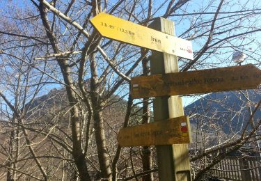
Trail Walking of 9.6 km to be discovered at Autonomous Community of the Basque Country, Gipuzkoa, Irun. This trail is proposed by DECHAMPD.
Description
Le massif basque
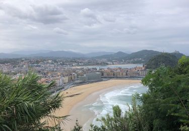
Le parc naturel d'Aiako Harria se situe sur les contreforts des Pyrénées, à l'extrémité orientale de la province de Guipúzcoa. Il englobe les territoires des communes d'Irún, d'Oiartzun, de Rentería, d'Hernani et de Donostia.
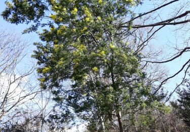
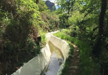
Le relief d'Aiako Harria est particulièrement tourmenté. Il est formé d'une mosaïque de montagnes et de gorges irriguées par de nombreux torrents qui, en raison de leur proximité avec la mer, doivent franchir de grands dénivelés sur de très courtes distances.La végétation du parc est typiquement atlantique. Cependant, on trouve quelques éléments méditerranéens dans les parties basses et ensoleillées. Ce sont les forêts de chênes qui occupent le plus de place ici ; on les trouve sur les plus grandes portions des versants.Mais on ne saurait ignorer les concentrations de hêtres, de châtaigniers et de pins. Quant à la faune du parc, impossible de ne pas évoquer la présence de 170 espèces de vertébrés, et de celle des oiseaux qui ne visitent les lieux que pendant l'hiver ou lors de leurs migrations.
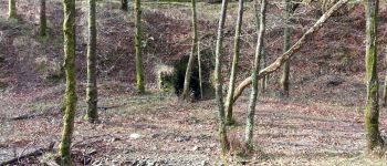
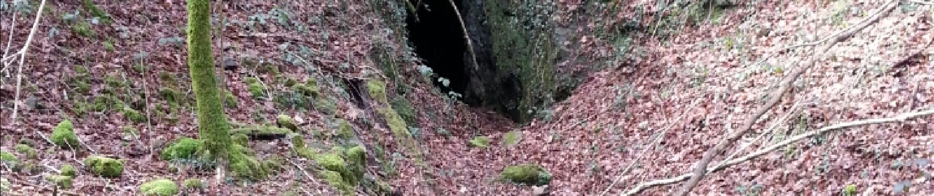
Anciennes mines
Au sein de cette masse rocheuse constituée de magma solidifié se sont formés des filons de métaux divers. Ces filons ont été exploités depuis les plus anciens temps, certains d'entre eux à l'époque romaine, et les puits et galeries minières qui creusent le massif se comptent par dizaines. On a calculé que les tunnels ont une longueur totale de 15 à 18 km
Positioning
Comments
Trails nearby
![Trail Walking Biriatou - Biriatou et lac Poiriers - Photo](https://media.geolcdn.com/t/375/260/ext.jpg?maxdim=2&url=https%3A%2F%2Fservices.sitytrail.com%2FGeolivesWS%2FDownloadMedia.ashx%3FTrailID%3D444455%26Media%3D20150712102756.jpg)
![Walking Walking](https://static1.geolcdn.com/sitytour/trail-icons/101.png)
Walking
![](/images/other/stat-length.png)
![](https://static1.geolcdn.com/siteimages/upload/files/16400158638029165_repeat_loop_refresh_sync_direction_icon.png)
![Trail Walking Irun - cascade dEnbido- Aitzondo mines et ravin de Meazuri 2024/11/12 - Photo](https://media.geolcdn.com/t/375/260/ea942abe-41d1-4bc7-b9a0-e2b821ade3bf.jpeg&format=jpg&maxdim=2)
![Walking Walking](https://static1.geolcdn.com/sitytour/trail-icons/101.png)
Walking
![](/images/other/stat-length.png)
![](https://static1.geolcdn.com/siteimages/upload/files/16400158638029165_repeat_loop_refresh_sync_direction_icon.png)
![Trail Walking Irun - Ibarla - Cascade d'Aitzondo - Ermitage san Martzial 2024 01 21 - Photo](https://media.geolcdn.com/t/375/260/ext.jpg?maxdim=2&url=https%3A%2F%2Fservices.sitytrail.com%2FGeolivesWS%2FDownloadMedia.ashx%3FTrailID%3D530456%26Media%3Dfix__20160226111436.jpg)
![Walking Walking](https://static1.geolcdn.com/sitytour/trail-icons/101.png)
Walking
![](/images/other/stat-length.png)
![](https://static1.geolcdn.com/siteimages/upload/files/16400158638029165_repeat_loop_refresh_sync_direction_icon.png)
![Trail On foot Irun - SL-GI 1006 Cascada de Aitzondo - Photo](https://media.geolcdn.com/t/375/260/949c10e2-10b5-4598-a875-2bd7cf386c52.jpeg&format=jpg&maxdim=2)
![On foot On foot](https://static1.geolcdn.com/sitytour/trail-icons/100.png)
On foot
![](/images/other/stat-length.png)
![](https://static1.geolcdn.com/siteimages/upload/files/16400158638029165_repeat_loop_refresh_sync_direction_icon.png)
![Trail Walking Biriatou - biriatou chemin de la foret - Photo](https://media.geolcdn.com/t/375/260/88e58450-9581-446b-a93b-1872d9ed62c8.jpg&format=jpg&maxdim=2)
![Walking Walking](https://static1.geolcdn.com/sitytour/trail-icons/101.png)
Walking
![](/images/other/stat-length.png)
![](https://static1.geolcdn.com/siteimages/upload/files/16400158638029165_repeat_loop_refresh_sync_direction_icon.png)
![Trail Walking Irun - Ibarla - Cascade d'Aitzondo - Ermitage san Martzial 2020 01 21 - Photo](https://media.geolcdn.com/t/375/260/ext.jpg?maxdim=2&url=https%3A%2F%2Fservices.sitytrail.com%2FGeolivesWS%2FDownloadMedia.ashx%3FTrailID%3D530456%26Media%3Dfix__20160226111436.jpg)
![Walking Walking](https://static1.geolcdn.com/sitytour/trail-icons/101.png)
Walking
![](/images/other/stat-length.png)
![](https://static1.geolcdn.com/siteimages/upload/files/16400158638029165_repeat_loop_refresh_sync_direction_icon.png)
![Trail Walking Hendaye - Hendaye Saint Sébastien GR121 Sentier du littoral - Photo](https://media.geolcdn.com/t/375/260/cc4c2380-6e4a-4daa-be29-494539f023ee.jpg&format=jpg&maxdim=2)
![Walking Walking](https://static1.geolcdn.com/sitytour/trail-icons/101.png)
Walking
![](/images/other/stat-length.png)
![](https://static1.geolcdn.com/siteimages/upload/files/16400158638029165_repeat_loop_refresh_sync_direction_icon.png)
![Trail Walking Irun - Boucle 3 couronnes - Photo](https://media.geolcdn.com/t/375/260/41c00aa6-38bd-42a4-af79-2355a90b16df.jpg&format=jpg&maxdim=2)
![Walking Walking](https://static1.geolcdn.com/sitytour/trail-icons/101.png)
Walking
![](/images/other/stat-length.png)
![](https://static1.geolcdn.com/siteimages/upload/files/16400158638029165_repeat_loop_refresh_sync_direction_icon.png)
![Trail Walking Lesaka - Embalse de Endara 2017 05 09x_backup - Photo](https://media.geolcdn.com/t/375/260/ext.jpg?maxdim=2&url=https%3A%2F%2Fservices.sitytrail.com%2FGeolivesWS%2FDownloadMedia.ashx%3FTrailID%3D749803%26Media%3Dfix__20170125124449.jpg)
![Walking Walking](https://static1.geolcdn.com/sitytour/trail-icons/101.png)
Walking
![](/images/other/stat-length.png)
![](https://static1.geolcdn.com/siteimages/upload/files/16400158638029165_repeat_loop_refresh_sync_direction_icon.png)