Trail Cycle Le Bourget-du-Lac - Tour lac du BOURGET - Photo
 peps73
peps73

User

© OpenStreetMap contributors
Length
Length
51 km
Max alt
Max alt
641 m
Uphill gradient
Uphill gradient
989 m
Km-Effort
Km-Effort  
65 km
Min alt
Min alt
230 m
Downhill gradient
Downhill gradient
988 m
Boucle
Boucle
Yes
Creation date :
2016-03-09 00:00:00.0
Updated on :
2016-03-09 00:00:00.0

(0 Reviews)

Cycle
Cycle
2h15
Difficulty : Unknown

Scan this QR Code to open this trail in the SityTrail application

FREE GPS app for hiking

Logo SityTrail SityTrail

IGN / Geographical institutes

Download SityTrail from the App Store Download SityTrail from Google Play

Logo SityTrail SityTrail World

The world is yours!

Download SityTrail from the App Store Download SityTrail from Google Play Download SityTrail on Huawei AppGallery

About

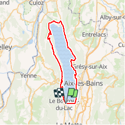
Trail Cycle of 51 km to be discovered at Auvergne-Rhône-Alpes, Savoy, Le Bourget-du-Lac. This trail is proposed by peps73.

Description

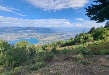
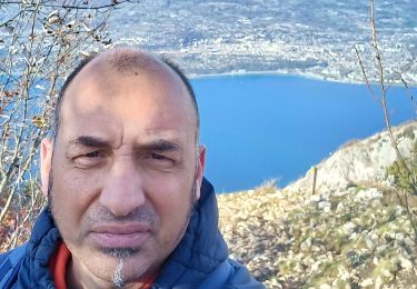
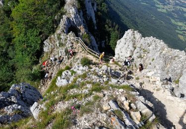
Tour du lac du Bourget "classique" via Bourdeau, La Chapelle du Mont du Chat, Conjux, Brison, Aix.

A faire dans le sens des aiguilles d'une montre ... mais aussi dans l'autre sens

Elevation profile

Positioning

Country:
France
Region :
Auvergne-Rhône-Alpes
Department/Province :
Savoy
Municipality :
Le Bourget-du-Lac
Location:
Unknown
Start:(UTM)
723312 ; 5058946 (31T) N.

Trails nearby

Trail Walking Le Bourget-du-Lac - La Dent du Chat 1390m, le Molard Noir 1452m - Photo
Walking
tracegps

Walking

Difficult
(4)
Le Bourget-du-Lac, Auvergne-Rhône-Alpes, Savoy, France
6.6 km | 13.7 km-effort
3h 30min
Yes
Trail Mountain bike Le Bourget-du-Lac - Chartreuse - Col du Crucifix - Photo
Mountain bike
tracegps

Mountain bike

Difficult
(2)
Le Bourget-du-Lac, Auvergne-Rhône-Alpes, Savoy, France
27 km | 40 km-effort
4h 0min
Yes
Trail Via ferrata La Chapelle-du-Mont-du-Chat - 2011-04-03 via ferrata Col du chat - Photo
Via ferrata
phschaefer

Via ferrata

Easy
(1)
La Chapelle-du-Mont-du-Chat, Auvergne-Rhône-Alpes, Savoy, France
3.6 km | 6.8 km-effort
Unknown
No
Trail Walking Le Bourget-du-Lac - Dent du Chat,  Mollard Noir,  Refuge du Relais du Chat au départ du Sentier Botanique  - Photo
Walking
Zasa

Walking

Medium
Le Bourget-du-Lac, Auvergne-Rhône-Alpes, Savoy, France
12.8 km | 25 km-effort
4h 0min
Yes
Trail Walking La Chapelle-du-Mont-du-Chat - 270523 Tour et Dent du Chat - Photo
Walking
mzonzon05

Walking

Easy
La Chapelle-du-Mont-du-Chat, Auvergne-Rhône-Alpes, Savoy, France
10 km | 21 km-effort
4h 15min
Yes
Trail Walking Le Bourget-du-Lac - mixte Pierre Nioule/croix du signal  - Photo
Walking
Zasa

Walking

Easy
Le Bourget-du-Lac, Auvergne-Rhône-Alpes, Savoy, France
11 km | 21 km-effort
3h 0min
Yes
Trail Walking Le Bourget-du-Lac - Le Molard du mont du Chat - Photo
Walking
crocau

Walking

Very easy
(1)
Le Bourget-du-Lac, Auvergne-Rhône-Alpes, Savoy, France
3.1 km | 4.5 km-effort
1h 32min
Yes
Trail Walking Le Bourget-du-Lac - DENT DU CHAT - MOLARD NOIR - Photo
Walking
djeepee74

Walking

Medium
(1)
Le Bourget-du-Lac, Auvergne-Rhône-Alpes, Savoy, France
7.1 km | 14.3 km-effort
3h 30min
Yes
Trail Walking La Chapelle-du-Mont-du-Chat - Le col du chat en savoie - Photo
Walking
colomb24

Walking

Very difficult
La Chapelle-du-Mont-du-Chat, Auvergne-Rhône-Alpes, Savoy, France
10.7 km | 22 km-effort
8h 57min
Yes


Close
My subscriptions