![](/images/other/stat-length.png)
![Trail Walking Fresnoy-Folny - Fresnoy-Folny - Photo](https://media.geolcdn.com/t/1900/400/ext.pjpeg?maxdim=2&url=https%3A%2F%2Fstatic1.geolcdn.com%2Fsiteimages%2Fupload%2Ffiles%2F1553511878bg_sport_marche.png)
Fresnoy-Folny
BaladesEN
User
![Length](/images/other/stat-length.png)
Length
15.4 km
![Max alt](https://static1.geolcdn.com/siteimages/upload/files/1508320355ic_sort_altitude_max_24dp.png)
Max alt
202 m
![Uphill gradient](https://static1.geolcdn.com/siteimages/upload/files/1508320355ic_sort_den_pos_24dp.png)
Uphill gradient
131 m
![Km-Effort](/images/other/stat-length.png)
Km-Effort
17.2 km
![Min alt](https://static1.geolcdn.com/siteimages/upload/files/1508320355ic_sort_altitude_min_24dp.png)
Min alt
128 m
![Downhill gradient](https://static1.geolcdn.com/siteimages/upload/files/1508320355ic_sort_den_neg_24dp.png)
Downhill gradient
125 m
![Boucle](https://static1.geolcdn.com/siteimages/upload/files/16400158638029165_repeat_loop_refresh_sync_direction_icon.png)
Boucle
No
Creation date :
2016-03-09 00:00:00.0
Updated on :
2016-03-09 00:00:00.0
![Walking](https://static1.geolcdn.com/sitytour/trail-icons/101.png)
3h47
Difficulty : Medium
![Scan this QR Code to open this trail in the SityTrail application](https://capi.geolives.com/qq0zvz2zws4bq2lad0pu/sitytour/trails/522987/qr.png?size=200)
FREE GPS app for hiking
About
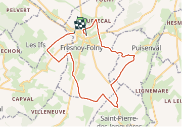
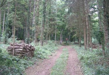
Trail Walking of 15.4 km to be discovered at Normandy, Seine-Maritime, Fresnoy-Folny. This trail is proposed by BaladesEN.
Description
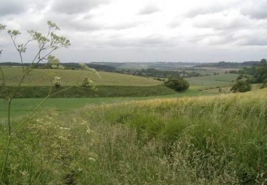
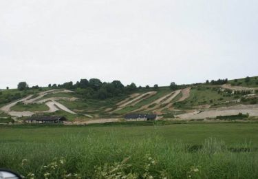
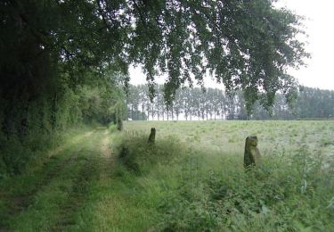
Cette randonnée nous promène autour de Fresnoy-Folny dans un paysage de plaine agricole. La descente dans les fonds de Londinières, et la remontée du fond du Vau Gosse, offrent des paysages superbes. http://baladesennormandie.fr
Positioning
Country:
France
Region :
Normandy
Department/Province :
Seine-Maritime
Municipality :
Fresnoy-Folny
Location:
Unknown
Start:(Dec)
Start:(UTM)
386620 ; 5527611 (31U) N.
Comments
Trails nearby
![Trail Walking Wanchy-Capval - Circuit de Wanchy - Capval - Photo](https://media.geolcdn.com/t/375/260/ext.jpg?maxdim=2&url=https%3A%2F%2Fservices.sitytrail.com%2FGeolivesWS%2FDownloadMedia.ashx%3FTrailID%3D172393%26Media%3D13739_5.jpg)
![Walking Walking](https://static1.geolcdn.com/sitytour/trail-icons/101.png)
Circuit de Wanchy - Capval
Walking
Medium
(1)
Wanchy-Capval,
Normandy,
Seine-Maritime,
France
![](/images/other/stat-length.png)
11.6 km | 13.9 km-effort
2h 55min
![](https://static1.geolcdn.com/siteimages/upload/files/16400158638029165_repeat_loop_refresh_sync_direction_icon.png)
Yes
![Trail Walking Saint-Pierre-des-Jonquières - Circuit de Saint Pierre des Jonquières - Photo](https://media.geolcdn.com/t/375/260/ext.jpg?maxdim=2&url=https%3A%2F%2Fservices.sitytrail.com%2FGeolivesWS%2FDownloadMedia.ashx%3FTrailID%3D172397%26Media%3D13743_5.jpg)
![Walking Walking](https://static1.geolcdn.com/sitytour/trail-icons/101.png)
Circuit de Saint Pierre des Jonquières
Walking
Medium
Saint-Pierre-des-Jonquières,
Normandy,
Seine-Maritime,
France
![](/images/other/stat-length.png)
12.4 km | 15.1 km-effort
3h 4min
![](https://static1.geolcdn.com/siteimages/upload/files/16400158638029165_repeat_loop_refresh_sync_direction_icon.png)
Yes
![Trail Walking Fresnoy-Folny - Circuit de Fresnoy - Folny - Photo](https://media.geolcdn.com/t/375/260/ext.jpg?maxdim=2&url=https%3A%2F%2Fservices.sitytrail.com%2FGeolivesWS%2FDownloadMedia.ashx%3FTrailID%3D172396%26Media%3D13742_5.jpg)
![Walking Walking](https://static1.geolcdn.com/sitytour/trail-icons/101.png)
Circuit de Fresnoy - Folny
Walking
Very difficult
Fresnoy-Folny,
Normandy,
Seine-Maritime,
France
![](/images/other/stat-length.png)
20 km | 23 km-effort
5h 4min
![](https://static1.geolcdn.com/siteimages/upload/files/16400158638029165_repeat_loop_refresh_sync_direction_icon.png)
Yes
![Trail Walking Grandcourt - Circuit de Grandcourt - Photo](https://media.geolcdn.com/t/375/260/ext.jpg?maxdim=2&url=https%3A%2F%2Fservices.sitytrail.com%2FGeolivesWS%2FDownloadMedia.ashx%3FTrailID%3D172392%26Media%3D13738_1.jpg)
![Walking Walking](https://static1.geolcdn.com/sitytour/trail-icons/101.png)
Circuit de Grandcourt
Walking
Medium
Grandcourt,
Normandy,
Seine-Maritime,
France
![](/images/other/stat-length.png)
11.7 km | 14.8 km-effort
2h 55min
![](https://static1.geolcdn.com/siteimages/upload/files/16400158638029165_repeat_loop_refresh_sync_direction_icon.png)
Yes
![Trail On foot Fresnoy-Folny - Fresnoy-Folny - Photo](https://media.geolcdn.com/t/375/260/c313d663-d66c-4441-8760-235cb340c5aa.jpeg&format=jpg&maxdim=2)
![On foot On foot](https://static1.geolcdn.com/sitytour/trail-icons/100.png)
Fresnoy-Folny
On foot
Medium
Fresnoy-Folny,
Normandy,
Seine-Maritime,
France
![](/images/other/stat-length.png)
19.5 km | 22 km-effort
4h 55min
![](https://static1.geolcdn.com/siteimages/upload/files/16400158638029165_repeat_loop_refresh_sync_direction_icon.png)
Yes
![Trail Walking Wanchy-Capval - WANCHY-CAPVAL - Photo](https://media.geolcdn.com/t/375/260/ext.jpg?maxdim=2&url=https%3A%2F%2Fstatic1.geolcdn.com%2Fsiteimages%2Fupload%2Ffiles%2F1553511878bg_sport_marche.png)
![Walking Walking](https://static1.geolcdn.com/sitytour/trail-icons/101.png)
WANCHY-CAPVAL
Walking
Difficult
(1)
Wanchy-Capval,
Normandy,
Seine-Maritime,
France
![](/images/other/stat-length.png)
11 km | 13.3 km-effort
3h 0min
![](https://static1.geolcdn.com/siteimages/upload/files/16400158638029165_repeat_loop_refresh_sync_direction_icon.png)
Yes