Trail Snowshoes Névache - du refuge de Laval au refuge de Ricou A/R - Photo

du refuge de Laval au refuge de Ricou A/R

 destras
destras

User

© OpenStreetMap contributors
Length
Length
10.3 km
Max alt
Max alt
2412 m
Uphill gradient
Uphill gradient
568 m
Km-Effort
Km-Effort  
18 km
Min alt
Min alt
2008 m
Downhill gradient
Downhill gradient
595 m
Boucle
Boucle
No
Creation date :
2016-03-09 00:00:00.0
Updated on :
2016-03-09 00:00:00.0

(0 Reviews)

Snowshoes
Snowshoes
4h28
Difficulty : Medium

Scan this QR Code to open this trail in the SityTrail application

FREE GPS app for hiking

Logo SityTrail SityTrail

IGN / Geographical institutes

Download SityTrail from the App Store Download SityTrail from Google Play

Logo SityTrail SityTrail World

The world is yours!

Download SityTrail from the App Store Download SityTrail from Google Play Download SityTrail on Huawei AppGallery

About

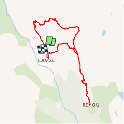
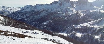
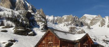
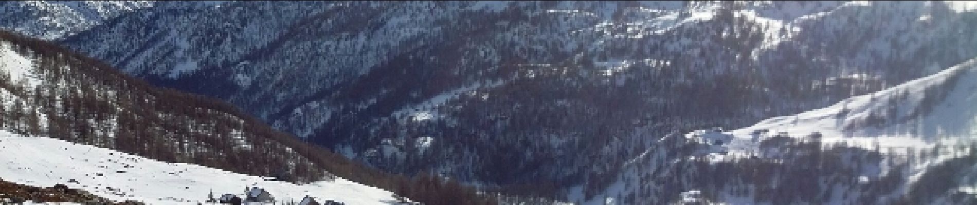
Trail Snowshoes of 10.3 km to be discovered at Provence-Alpes-Côte d'Azur, Hautes-Alpes, Névache. This trail is proposed by destras.

Description

Par le haut de la vallée de la Clarée, du refuge de Laval au refuge de Ricou aller et retour par une route différente.  

Elevation profile

Photos

Points of interest

Point of interest Névache - Ricou - Photo
destras
NÉVACHE 
Point of interest Névache - Refuge de Laval - Photo
destras
NÉVACHE 

Positioning

Country:
France
Region :
Provence-Alpes-Côte d'Azur
Department/Province :
Hautes-Alpes
Municipality :
Névache
Location:
Unknown
Start:(UTM)
305345 ; 4992540 (32T) N.

Trails nearby

Trail Walking Névache - Briançonnais Lac du Serpent - Photo
Walking
Orcal37

Walking

Medium
(2)
Névache, Provence-Alpes-Côte d'Azur, Hautes-Alpes, France
10 km | 18 km-effort
3h 10min
Yes
Trail Walking Névache - Col du Chardonnet - Névache - Photo
Walking
tracegps

Walking

Medium
(3)
Névache, Provence-Alpes-Côte d'Azur, Hautes-Alpes, France
12.3 km | 23 km-effort
4h 0min
Yes
Trail Walking Le Monêtier-les-Bains - Le Grand Lac - Photo
Walking
tracegps

Walking

Difficult
(2)
Le Monêtier-les-Bains, Provence-Alpes-Côte d'Azur, Hautes-Alpes, France
5.2 km | 12.8 km-effort
5h 0min
No
Trail Walking Le Monêtier-les-Bains - l'aiguillette du Lauzet par le grand lac - Photo
Walking
GUIDE
amiral13

Walking

Difficult
Le Monêtier-les-Bains, Provence-Alpes-Côte d'Azur, Hautes-Alpes, France
13.8 km | 29 km-effort
8h 39min
Yes
Trail Via ferrata Le Monêtier-les-Bains - Via ferrata Aiguillette du Lauzet 30/06/18 - Photo
Via ferrata
GUIDE
R@ph

Via ferrata

Medium
Le Monêtier-les-Bains, Provence-Alpes-Côte d'Azur, Hautes-Alpes, France
9.5 km | 21 km-effort
2h 30min
Yes
Trail Walking Névache - la roche du Chardonnet - Photo
Walking
GUIDE
amiral13

Walking

Medium
Névache, Provence-Alpes-Côte d'Azur, Hautes-Alpes, France
16.6 km | 29 km-effort
7h 26min
Yes
Trail Walking Névache - Lacs Laramon et Serpent - Photo
Walking
neoroll44

Walking

Medium
(2)
Névache, Provence-Alpes-Côte d'Azur, Hautes-Alpes, France
10.4 km | 21 km-effort
6h 0min
Yes
Trail Walking Le Monêtier-les-Bains - Haut tour des Cerces - Photo
Walking
druilhe

Walking

Very difficult
(1)
Le Monêtier-les-Bains, Provence-Alpes-Côte d'Azur, Hautes-Alpes, France
42 km | 77 km-effort
15h 27min
Yes
Trail Walking Névache - lacs laramon, du serpent, des gardioles et pic du lac blanc - Photo
Walking
GUIDE
amiral13

Walking

Medium
(1)
Névache, Provence-Alpes-Côte d'Azur, Hautes-Alpes, France
15.8 km | 31 km-effort
7h 30min
Yes


Close
My subscriptions