Trail Walking Ouffet - OUFFET - Balade du Néblon - Photo

OUFFET - Balade du Néblon

© OpenStreetMap contributors
Length
Length
13 km
Max alt
Max alt
303 m
Uphill gradient
Uphill gradient
285 m
Km-Effort
Km-Effort  
16.8 km
Min alt
Min alt
145 m
Downhill gradient
Downhill gradient
285 m
Boucle
Boucle
Yes
Signpost
Signpost
Creation date :
2014-12-10 00:00:00.0
Updated on :
2014-12-10 00:00:00.0

(0 Reviews)

Walking
Walking
3h35
Difficulty : Medium

Scan this QR Code to open this trail in the SityTrail application

FREE GPS app for hiking

Logo SityTrail SityTrail

IGN / Geographical institutes

Download SityTrail from the App Store Download SityTrail from Google Play

Logo SityTrail SityTrail World

The world is yours!

Download SityTrail from the App Store Download SityTrail from Google Play Download SityTrail on Huawei AppGallery

About

Trail Walking of 13 km to be discovered at Wallonia, Liège, Ouffet. This trail is proposed by henrineupre.

Description

Au départ de la Grand Place d'Ouffet, cette promenade permet la découverte du village pour ensuite emmener les promeneurs à travers champs, prairies et bois.

Elevation profile

Points of interest

Point of interest Ouffet - Grand'Place d'Ouffet - Photo
henrineupre
Point of interest Ouffet - Croix du Tô - Photo
henrineupre
OUFFET 
Point of interest Ouffet - Ferme-Château de Himbe - Photo
henrineupre
Point of interest Ouffet - Le Néblon - Photo
henrineupre
OUFFET 
Point of interest Ouffet - Néblon-le-Pierreux - Photo
henrineupre
Point of interest Ouffet - Tour de Justice - Photo
henrineupre
Point of interest Ouffet - Eglise Saint-Médard - Photo
henrineupre

Positioning

Country:
Belgium
Region :
Wallonia
Department/Province :
Liège
Municipality :
Ouffet
Location:
Ouffet
Start:(UTM)
675088 ; 5590257 (31U) N.

Trails nearby

Trail Walking Hamoir - HAMOIR (Vallée du Neblon) - Photo
Walking
GUIDE
Michel1963

Walking

Medium
(1)
Hamoir, Wallonia, Liège, Belgium
8.6 km | 11.4 km-effort
2h 28min
Yes
Trail On foot Anthisnes - AS03 Boucle de Tolumont - Photo
On foot
GUIDE+

On foot

Medium
(1)
Anthisnes, Wallonia, Liège, Belgium
13.4 km | 17.6 km-effort
3h 20min
Yes
Trail Walking Ferrières - GG-Lu-15_Sy - Barvaux - Photo
Walking
PRO

Walking

Very difficult
(1)
Ferrières, Wallonia, Liège, Belgium
18.9 km | 26 km-effort
5h 58min
No
Trail Walking Anthisnes - Anthines - AS03 - Boucle de Tolumont - Losange Bleu - Photo
Walking
Alfredy

Walking

Medium
(2)
Anthisnes, Wallonia, Liège, Belgium
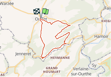
13.9 km | 18.2 km-effort
2h 56min
Yes
Trail Walking Hamoir - Hamoir - Sy - Les Crêtes  - Photo
Walking
GUIDE
Michel1963

Walking

Medium
(1)
Hamoir, Wallonia, Liège, Belgium
13.1 km | 17.2 km-effort
3h 17min
Yes
Trail Walking Ouffet - Warzée - Photo
Walking
Jacques Guisse

Walking

Easy
(1)
Ouffet, Wallonia, Liège, Belgium
10.3 km | 12.4 km-effort
2h 28min
Yes
Trail Walking Ouffet - ouffet fermes ac + - Photo
Walking
colsonandre

Walking

Medium
(2)
Ouffet, Wallonia, Liège, Belgium
8.6 km | 10.7 km-effort
2h 41min
Yes
Trail Walking Hamoir - RB-Lg-19_Hamoir_via-racc-2 - Photo
Walking
PRO

Walking

Very difficult
(4)
Hamoir, Wallonia, Liège, Belgium
16 km | 20 km-effort
4h 36min
Yes
Trail Walking Hamoir - RB-Lg-19_Hamoir_via-racc-1 - Photo
Walking
PRO

Walking

Difficult
(2)
Hamoir, Wallonia, Liège, Belgium
11.4 km | 15.1 km-effort
3h 26min
Yes


Close
My subscriptions