labastide du haut mont SityTrail > Trails > Outdoor > France > Occitania > Lot > Labastide-du-Haut-Mont SityTrail > Trails > Outdoor > France > Occitania > Lot > Labastide-du-Haut-Mont labastide du haut mont daniel46100 User 3D © OpenStreetMap contributors Length 13.1 km Max alt 783 m Uphill gradient 426 m Km-Effort 18.8 km Min alt 569 m Downhill gradient 424 m Boucle Yes Creation date : 2016-01-17 00:00:00.0 Updated on : 2022-09-14 08:17:38.132 (0 Reviews) Walking 3h56 Difficulty : Medium FREE GPS app for hiking SityTrail IGN / Geographical institutes SityTrail World The world is yours! About Trail Walking of 13.1 km to be discovered at Occitania, Lot, Labastide-du-Haut-Mont. This trail is proposed by daniel46100. Legends | More details (PDF) Elevation profile Legends > 15% 15% - 10% 10% - 5% flat 5% - 10% 10% - 15% 15% - 30% > 30% Positioning Country: France Region : Occitania Department/Province : Lot Municipality : Labastide-du-Haut-Mont Location: Unknown Start:(Dec) 44.834782 / 2.122335 Start:(UTM) 430628 ; 4964972 (31T) N. Comments Please log in to post a review or rate the element Trails nearby yves12 parlan Walking Medium (1) Parlan, Auvergne-Rhône-Alpes, Cantal, France 
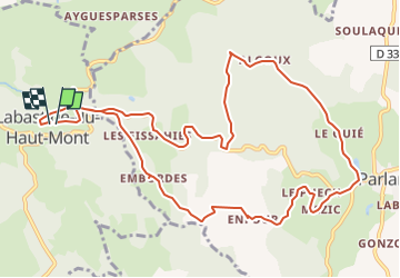
21 km | 28 km-effort 4h 40min Yes tracegps Circuit du lac du Tolerme - Sénaillac-Latronquière Walking Medium (1) Sénaillac-Latronquière, Occitania, Lot, France 8.9 km | 11.1 km-effort 2h 30min Yes Jean-Marie Bousquet Saint-Céré Road bike Medium Latronquière, Occitania, Lot, France 62 km | 76 km-effort 3h 15min Yes kayakiste15 circuit 11 amelioré Running Medium Sousceyrac-en-Quercy, Occitania, Lot, France 14.2 km | 18.6 km-effort 1h 25min Yes alainlissac Saint saur y Walking Saint-Saury, Auvergne-Rhône-Alpes, Cantal, France 5.9 km | 7.3 km-effort 1h 25min Yes Julie 46 2 Horseback riding Easy Labastide-du-Haut-Mont, Occitania, Lot, France 3.8 km | 4.9 km-effort 38min No