![](/images/other/stat-length.png)
![Trail Walking Charmes-sur-Rhône - les sentiers de Soyons 07. - Photo](https://media.geolcdn.com/t/1900/400/ext.pjpeg?maxdim=2&url=https%3A%2F%2Fstatic1.geolcdn.com%2Fsiteimages%2Fupload%2Ffiles%2F1553511878bg_sport_marche.png)
les sentiers de Soyons 07.
patchil
User
![Length](/images/other/stat-length.png)
![Max alt](https://static1.geolcdn.com/siteimages/upload/files/1508320355ic_sort_altitude_max_24dp.png)
![Uphill gradient](https://static1.geolcdn.com/siteimages/upload/files/1508320355ic_sort_den_pos_24dp.png)
![Km-Effort](/images/other/stat-length.png)
![Min alt](https://static1.geolcdn.com/siteimages/upload/files/1508320355ic_sort_altitude_min_24dp.png)
![Downhill gradient](https://static1.geolcdn.com/siteimages/upload/files/1508320355ic_sort_den_neg_24dp.png)
![Boucle](https://static1.geolcdn.com/siteimages/upload/files/16400158638029165_repeat_loop_refresh_sync_direction_icon.png)
![Walking](https://static1.geolcdn.com/sitytour/trail-icons/101.png)
1h12
Difficulty : Medium
![Scan this QR Code to open this trail in the SityTrail application](https://capi.geolives.com/qq0zvz2zws4bq2lad0pu/sitytour/trails/512961/qr.png?size=200)
FREE GPS app for hiking
About
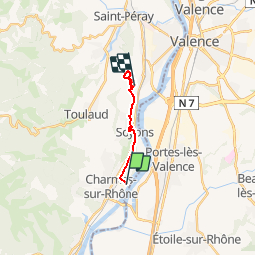
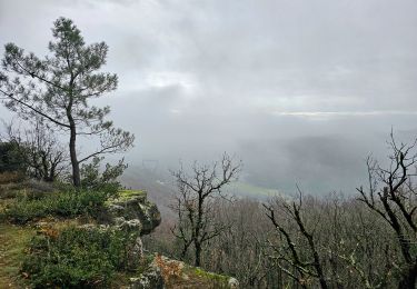
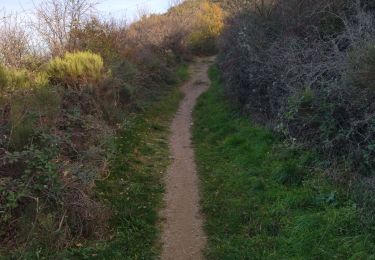
Trail Walking of 10.7 km to be discovered at Auvergne-Rhône-Alpes, Ardèche, Charmes-sur-Rhône. This trail is proposed by patchil.
Description
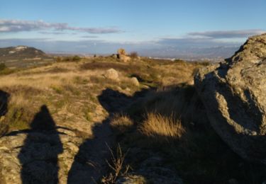
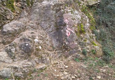
Ne pas tenir compte de la 1er partie qui longe la route de Charmes à Soyons car il s'agit d'une reconnaissance qui en réalité démarre de soyons pour arriver au déamrrage d'une randonnée qui passe par les hauteurs de Crussol. Les deux boucles du tracé sont des sentiers parfois très étroits mais encore reconnaissable, Aucun balisage sauf la flèche où on peut partir soit vers la droite ou la gauche.
Positioning
Comments
Trails nearby
![Trail Walking Beauchastel - Beauchastel. / Pierre Gourde - Photo](https://media.geolcdn.com/t/375/260/ext.jpg?maxdim=2&url=https%3A%2F%2Fservices.sitytrail.com%2FGeolivesWS%2FDownloadMedia.ashx%3FTrailID%3D500378%26Media%3Dfix__20151206162513.jpg)
![Walking Walking](https://static1.geolcdn.com/sitytour/trail-icons/101.png)
Walking
![](/images/other/stat-length.png)
![](https://static1.geolcdn.com/siteimages/upload/files/16400158638029165_repeat_loop_refresh_sync_direction_icon.png)
![Trail Walking Toulaud - 07 l'embroye zel 22.11.2024 - Photo](https://media.geolcdn.com/t/375/260/3eda46e6-363b-4cc8-80cc-ecb0005ecd9e.jpg&format=jpg&maxdim=2)
![Walking Walking](https://static1.geolcdn.com/sitytour/trail-icons/101.png)
Walking
![](/images/other/stat-length.png)
![](https://static1.geolcdn.com/siteimages/upload/files/16400158638029165_repeat_loop_refresh_sync_direction_icon.png)
![Trail Walking Toulaud - 07 toulaud - Photo](https://media.geolcdn.com/t/375/260/89acc3af-3d99-4629-8f1e-c7b281476088.jpg&format=jpg&maxdim=2)
![Walking Walking](https://static1.geolcdn.com/sitytour/trail-icons/101.png)
Walking
![](/images/other/stat-length.png)
![](https://static1.geolcdn.com/siteimages/upload/files/16400158638029165_repeat_loop_refresh_sync_direction_icon.png)
![Trail Walking Toulaud - l'Embroye - Photo](https://media.geolcdn.com/t/375/260/cb947bb6-7dc1-43ba-a067-9c4f7f015103.jpg&format=jpg&maxdim=2)
![Walking Walking](https://static1.geolcdn.com/sitytour/trail-icons/101.png)
Walking
![](/images/other/stat-length.png)
![](https://static1.geolcdn.com/siteimages/upload/files/16400158638029165_repeat_loop_refresh_sync_direction_icon.png)
![Trail Walking Saint-Georges-les-Bains - Saint Georges les Bains - Photo](https://media.geolcdn.com/t/375/260/e93486d4-d5f4-4b3e-8536-d4298013ea4d.jpg&format=jpg&maxdim=2)
![Walking Walking](https://static1.geolcdn.com/sitytour/trail-icons/101.png)
Walking
![](/images/other/stat-length.png)
![](https://static1.geolcdn.com/siteimages/upload/files/16400158638029165_repeat_loop_refresh_sync_direction_icon.png)
![Trail Walking Saint-Georges-les-Bains - col de Rotison - Photo](https://media.geolcdn.com/t/375/260/8c3d1009-c72f-4ec6-bf61-7a2fde476dc2.jpg&format=jpg&maxdim=2)
![Walking Walking](https://static1.geolcdn.com/sitytour/trail-icons/101.png)
Walking
![](/images/other/stat-length.png)
![](https://static1.geolcdn.com/siteimages/upload/files/16400158638029165_repeat_loop_refresh_sync_direction_icon.png)
![Trail Walking Toulaud - 07 gorges embroye - Photo](https://media.geolcdn.com/t/375/260/d81e90ab-1575-4c8f-b98f-1b96e0b43ac1.jpg&format=jpg&maxdim=2)
![Walking Walking](https://static1.geolcdn.com/sitytour/trail-icons/101.png)
Walking
![](/images/other/stat-length.png)
![](https://static1.geolcdn.com/siteimages/upload/files/16400158638029165_repeat_loop_refresh_sync_direction_icon.png)
![Trail Walking Toulaud - Gorges de l'Embroye - Photo](https://media.geolcdn.com/t/375/260/050f228b-bc3c-4cca-b6f5-b260ca37e31b.jpg&format=jpg&maxdim=2)
![Walking Walking](https://static1.geolcdn.com/sitytour/trail-icons/101.png)
Walking
![](/images/other/stat-length.png)
![](https://static1.geolcdn.com/siteimages/upload/files/16400158638029165_repeat_loop_refresh_sync_direction_icon.png)
![Trail Walking Beauchastel - 2022-06-25_20h37m57_Beauchastel 16,5km.gpx (1).xml - Photo](https://media.geolcdn.com/t/375/260/c478205d-33f4-4e99-b83b-07be3d25d520.jpg&format=jpg&maxdim=2)
![Walking Walking](https://static1.geolcdn.com/sitytour/trail-icons/101.png)
Walking
![](/images/other/stat-length.png)
![](https://static1.geolcdn.com/siteimages/upload/files/16400158638029165_repeat_loop_refresh_sync_direction_icon.png)