![](/images/other/stat-length.png)
![Trail Walking Maringues - maringues - Photo](https://media.geolcdn.com/t/1900/400/ext.pjpeg?maxdim=2&url=https%3A%2F%2Fstatic1.geolcdn.com%2Fsiteimages%2Fupload%2Ffiles%2F1553511878bg_sport_marche.png)
maringues
guy63
User
![Length](/images/other/stat-length.png)
![Max alt](https://static1.geolcdn.com/siteimages/upload/files/1508320355ic_sort_altitude_max_24dp.png)
![Uphill gradient](https://static1.geolcdn.com/siteimages/upload/files/1508320355ic_sort_den_pos_24dp.png)
![Km-Effort](/images/other/stat-length.png)
![Min alt](https://static1.geolcdn.com/siteimages/upload/files/1508320355ic_sort_altitude_min_24dp.png)
![Downhill gradient](https://static1.geolcdn.com/siteimages/upload/files/1508320355ic_sort_den_neg_24dp.png)
![Boucle](https://static1.geolcdn.com/siteimages/upload/files/16400158638029165_repeat_loop_refresh_sync_direction_icon.png)
![Walking](https://static1.geolcdn.com/sitytour/trail-icons/101.png)
4h24
Difficulty : Medium
![Scan this QR Code to open this trail in the SityTrail application](https://capi.geolives.com/qq0zvz2zws4bq2lad0pu/sitytour/trails/509496/qr.png?size=200)
FREE GPS app for hiking
About
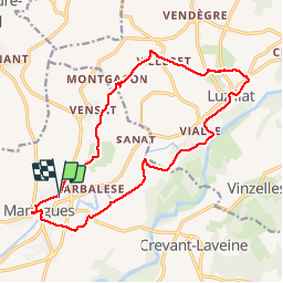
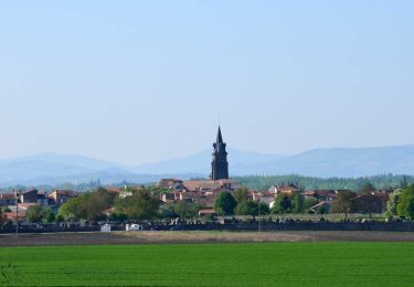
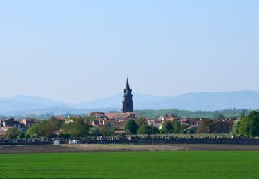
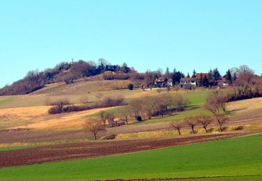
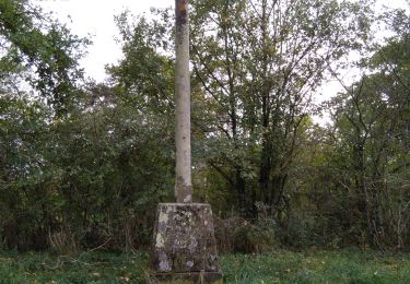
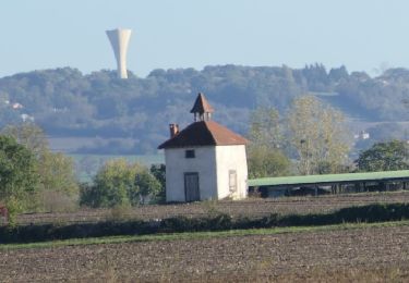
Trail Walking of 17.7 km to be discovered at Auvergne-Rhône-Alpes, Puy-de-Dôme, Maringues. This trail is proposed by guy63.
Description
Départ parking Terrain des Sports point GPS Longitude : 3° 20' 8.8' E Latitude : 45° 55' 29.9' N. en traversant la ville prendre le temps de regarder les anciennes bâtisses en pierre de Volvic, le marché couvert, sur le parvis de l’Eglise la superbe vue sur la chaine des puys. Bon chemin partie boisée, l’autre longeant les pâturages et cour d’eau. En montant la bute de Montgacon allez à la vierge une vue à 360° sur tous les monts de la région. Vous êtes sur la plaine de la Limagne, respectez la nature ne pas sortir des chemins.
Positioning
Comments
Trails nearby
![Trail On foot Maringues - La Butte de Montgacon - circuit court - Photo](https://media.geolcdn.com/t/375/260/ab4843d0-b44d-4ab7-8595-840f5a55ca60.jpeg&format=jpg&maxdim=2)
![On foot On foot](https://static1.geolcdn.com/sitytour/trail-icons/100.png)
On foot
![](/images/other/stat-length.png)
![](https://static1.geolcdn.com/siteimages/upload/files/16400158638029165_repeat_loop_refresh_sync_direction_icon.png)
![Trail On foot Luzillat - La Butte de Montgacon - Photo](https://media.geolcdn.com/t/375/260/dae0ac9a-ba68-464f-a0a3-8b55925d12f4.jpeg&format=jpg&maxdim=2)
![On foot On foot](https://static1.geolcdn.com/sitytour/trail-icons/100.png)
On foot
![](/images/other/stat-length.png)
![](https://static1.geolcdn.com/siteimages/upload/files/16400158638029165_repeat_loop_refresh_sync_direction_icon.png)
![Trail On foot Vinzelles - Entre Crevant et Laveine - Photo](https://media.geolcdn.com/t/375/260/dd947ee4-d5c1-4bf1-b419-c5f2be4d1510.jpeg&format=jpg&maxdim=2)
![On foot On foot](https://static1.geolcdn.com/sitytour/trail-icons/100.png)
On foot
![](/images/other/stat-length.png)
![](https://static1.geolcdn.com/siteimages/upload/files/16400158638029165_repeat_loop_refresh_sync_direction_icon.png)
![Walking Walking](https://static1.geolcdn.com/sitytour/trail-icons/101.png)
Walking
![](/images/other/stat-length.png)
![](https://static1.geolcdn.com/siteimages/upload/files/16400158638029165_repeat_loop_refresh_sync_direction_icon.png)
![Trail Walking Maringues - Maringues_Butte_Montgacon - Photo](https://media.geolcdn.com/t/375/260/fef1ecfc-3d14-4465-b9c8-110655272baa.jpg&format=jpg&maxdim=2)
![Walking Walking](https://static1.geolcdn.com/sitytour/trail-icons/101.png)
Walking
![](/images/other/stat-length.png)
![](https://static1.geolcdn.com/siteimages/upload/files/16400158638029165_repeat_loop_refresh_sync_direction_icon.png)
![Trail Walking Crevant-Laveine - [Itinéraire] Entre Crevant et Laveine - Photo](https://media.geolcdn.com/t/375/260/6fa182a0-77c3-4ab4-a1f7-73c600d86e47.png&format=jpg&maxdim=2)
![Walking Walking](https://static1.geolcdn.com/sitytour/trail-icons/101.png)
Walking
![](/images/other/stat-length.png)
![](https://static1.geolcdn.com/siteimages/upload/files/16400158638029165_repeat_loop_refresh_sync_direction_icon.png)
![Walking Walking](https://static1.geolcdn.com/sitytour/trail-icons/101.png)
Walking
![](/images/other/stat-length.png)
![](https://static1.geolcdn.com/siteimages/upload/files/16400158638029165_repeat_loop_refresh_sync_direction_icon.png)
![Trail Walking Crevant-Laveine - crevant Laveine par les chemins - Photo](https://media.geolcdn.com/t/375/260/65c9ac11-9bc3-49c0-96c9-fc6caab54fb2.jpg&format=jpg&maxdim=2)
![Walking Walking](https://static1.geolcdn.com/sitytour/trail-icons/101.png)
Walking
![](/images/other/stat-length.png)
![](https://static1.geolcdn.com/siteimages/upload/files/16400158638029165_repeat_loop_refresh_sync_direction_icon.png)
![Trail Walking Saint-Laure - 2022-10-25 Saint Laure - Photo](https://media.geolcdn.com/t/375/260/c8f90e77-25e2-4769-a5e7-90ee0c50591a.png&format=jpg&maxdim=2)
![Walking Walking](https://static1.geolcdn.com/sitytour/trail-icons/101.png)
Walking
![](/images/other/stat-length.png)
![](https://static1.geolcdn.com/siteimages/upload/files/16400158638029165_repeat_loop_refresh_sync_direction_icon.png)