Trail Walking Sagunt / Sagunto - gilet - Photo
© OpenStreetMap contributors
Length
Length
6.9 km
Max alt
Max alt
117 m
Uphill gradient
Uphill gradient
112 m
Km-Effort
Km-Effort  
8.4 km
Min alt
Min alt
71 m
Downhill gradient
Downhill gradient
102 m
Boucle
Boucle
Yes
Creation date :
2016-01-04 00:00:00.0
Updated on :
2016-01-04 00:00:00.0

(0 Reviews)

Walking
Walking
1h32
Difficulty : Easy

Scan this QR Code to open this trail in the SityTrail application

FREE GPS app for hiking

Logo SityTrail SityTrail

IGN / Geographical institutes

Download SityTrail from the App Store Download SityTrail from Google Play

Logo SityTrail SityTrail World

The world is yours!

Download SityTrail from the App Store Download SityTrail from Google Play Download SityTrail on Huawei AppGallery

About

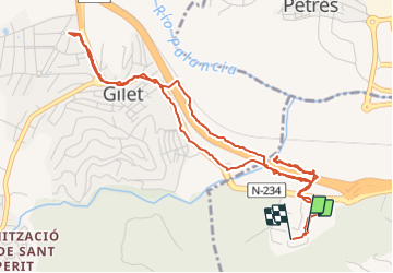
Trail Walking of 6.9 km to be discovered at Valencian Community, Valencia, Sagunt / Sagunto. This trail is proposed by martinromofrancis.

Description

facile

Elevation profile

Photos

Points of interest

Point of interest Sagunt / Sagunto - Point 1 - Photo
martinromofrancis
SAGUNT / SAGUNTO 

Positioning

Country:
Spain
Region :
Valencian Community
Department/Province :
Valencia
Municipality :
Sagunt / Sagunto
Location:
Unknown
Start:(UTM)
730687 ; 4394621 (30S) N.

Trails nearby

Trail Walking Albalat dels Tarongers - gr-10-circular-la-canal-del-garbi-un-pequeno-reto-penyes-del - Photo
Walking
vitis34

Walking

Very difficult
Albalat dels Tarongers, Valencian Community, Valencia, Spain
8.2 km | 14.2 km-effort
3h 1min
Yes


Close
My subscriptions