![](/images/other/stat-length.png)
![Trail Walking Tanneron - Les crêtes de Tanneron 2 - Photo](https://media.geolcdn.com/t/1900/400/ext.pjpeg?maxdim=2&url=https%3A%2F%2Fservices.sitytrail.com%2FGeolivesWS%2FDownloadMedia.ashx%3FTrailID%3D508031%26Media%3Dfix__20151230110125.jpg)
Les crêtes de Tanneron 2
Sugg
User
![Length](/images/other/stat-length.png)
![Max alt](https://static1.geolcdn.com/siteimages/upload/files/1508320355ic_sort_altitude_max_24dp.png)
![Uphill gradient](https://static1.geolcdn.com/siteimages/upload/files/1508320355ic_sort_den_pos_24dp.png)
![Km-Effort](/images/other/stat-length.png)
![Min alt](https://static1.geolcdn.com/siteimages/upload/files/1508320355ic_sort_altitude_min_24dp.png)
![Downhill gradient](https://static1.geolcdn.com/siteimages/upload/files/1508320355ic_sort_den_neg_24dp.png)
![Boucle](https://static1.geolcdn.com/siteimages/upload/files/16400158638029165_repeat_loop_refresh_sync_direction_icon.png)
![Walking](https://static1.geolcdn.com/sitytour/trail-icons/101.png)
4h58
Difficulty : Medium
![Scan this QR Code to open this trail in the SityTrail application](https://capi.geolives.com/qq0zvz2zws4bq2lad0pu/sitytour/trails/508031/qr.png?size=200)
FREE GPS app for hiking
About
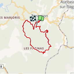
Trail Walking of 15.4 km to be discovered at Provence-Alpes-Côte d'Azur, Var, Tanneron. This trail is proposed by Sugg.
Description
30 décembre 2015.
Reco des crêtes de Tanneron avec Pierre pour la rando prévue le 13 janvier 2016.
Ce circuit est balisé, les pistes sont très détériorées dans la première partie,et le dénivelé important.
la deuxième partie est plus facile.
On espère voir les mimosas en fleurs, certaines variétés sont déjà bien avancées.
Positioning
Comments
Trails nearby
![Trail On foot Tanneron - La chapelle de St Cassien des bois, le pont détruit et au fil de l'eau - Photo](https://media.geolcdn.com/t/375/260/a22ee1a2-3869-418b-b8c3-03abedec3efc.jpg&format=jpg&maxdim=2)
![On foot On foot](https://static1.geolcdn.com/sitytour/trail-icons/100.png)
On foot
![](/images/other/stat-length.png)
![](https://static1.geolcdn.com/siteimages/upload/files/16400158638029165_repeat_loop_refresh_sync_direction_icon.png)
![Trail Walking Tanneron - Tanneron les mimosas - Photo](https://media.geolcdn.com/t/375/260/12594504-e357-426b-8d56-deee61931ae8.jpg&format=jpg&maxdim=2)
![Walking Walking](https://static1.geolcdn.com/sitytour/trail-icons/101.png)
Walking
![](/images/other/stat-length.png)
![](https://static1.geolcdn.com/siteimages/upload/files/16400158638029165_repeat_loop_refresh_sync_direction_icon.png)
![Trail Walking Tanneron - Tanneron - petite boucle 12-02-2022 - Photo](https://media.geolcdn.com/t/375/260/4604518f-6a34-43cf-8b51-a998f24d7a22.jpg&format=jpg&maxdim=2)
![Walking Walking](https://static1.geolcdn.com/sitytour/trail-icons/101.png)
Walking
![](/images/other/stat-length.png)
![](https://static1.geolcdn.com/siteimages/upload/files/16400158638029165_repeat_loop_refresh_sync_direction_icon.png)
![Trail Walking Mandelieu-la-Napoule - Grand Duc Alternatif - Photo](https://media.geolcdn.com/t/375/260/ext.jpg?maxdim=2&url=https%3A%2F%2Fstatic1.geolcdn.com%2Fsiteimages%2Fupload%2Ffiles%2F1553511878bg_sport_marche.png)
![Walking Walking](https://static1.geolcdn.com/sitytour/trail-icons/101.png)
Walking
![](/images/other/stat-length.png)
![](https://static1.geolcdn.com/siteimages/upload/files/16400158638029165_repeat_loop_refresh_sync_direction_icon.png)
![Trail Walking Mandelieu-la-Napoule - Grand Duc - Photo](https://media.geolcdn.com/t/375/260/bb4952b6-32f3-40dd-b274-07cfc3d80de4.jpg&format=jpg&maxdim=2)
![Walking Walking](https://static1.geolcdn.com/sitytour/trail-icons/101.png)
Walking
![](/images/other/stat-length.png)
![](https://static1.geolcdn.com/siteimages/upload/files/16400158638029165_repeat_loop_refresh_sync_direction_icon.png)
![Trail Walking Tanneron - Crêtes du Tanneron - Photo](https://media.geolcdn.com/t/375/260/d09f9b2b-44ce-4ff4-a28b-df768b7c8122.jpg&format=jpg&maxdim=2)
![Walking Walking](https://static1.geolcdn.com/sitytour/trail-icons/101.png)
Walking
![](/images/other/stat-length.png)
![](https://static1.geolcdn.com/siteimages/upload/files/16400158638029165_repeat_loop_refresh_sync_direction_icon.png)
![Trail sport Tanneron - Tanneron - Photo](https://media.geolcdn.com/t/375/260/974aadb2-79c8-4954-8761-9180120909fd.jpg&format=jpg&maxdim=2)
sport
![](/images/other/stat-length.png)
![](https://static1.geolcdn.com/siteimages/upload/files/16400158638029165_repeat_loop_refresh_sync_direction_icon.png)
![Trail Walking Tanneron - 2024-02-16 Tanneron Mimosas - Photo](https://media.geolcdn.com/t/375/260/ec7db3bf-cda8-4c96-a43b-2447256cb9f8.jpg&format=jpg&maxdim=2)
![Walking Walking](https://static1.geolcdn.com/sitytour/trail-icons/101.png)
Walking
![](/images/other/stat-length.png)
![](https://static1.geolcdn.com/siteimages/upload/files/16400158638029165_repeat_loop_refresh_sync_direction_icon.png)
![Trail Mountain bike Tanneron - autour de tanneron - Photo](https://media.geolcdn.com/t/375/260/ext.jpg?maxdim=2&url=https%3A%2F%2Fstatic1.geolcdn.com%2Fsiteimages%2Fupload%2Ffiles%2F1524743154velo.jpg)
![Mountain bike Mountain bike](https://static1.geolcdn.com/sitytour/trail-icons/202.png)
Mountain bike
![](/images/other/stat-length.png)
![](https://static1.geolcdn.com/siteimages/upload/files/16400158638029165_repeat_loop_refresh_sync_direction_icon.png)
Tanneron c'est....tu montes beaucoup,tu descends beaucoup et du plat un peu...