![](/images/other/stat-length.png)
![Trail Walking Boury-en-Vexin - Boury en Vexin - Breuil 9/12 - Photo](https://media.geolcdn.com/t/1900/400/ext.pjpeg?maxdim=2&url=https%3A%2F%2Fstatic1.geolcdn.com%2Fsiteimages%2Fupload%2Ffiles%2F1553511878bg_sport_marche.png)
Boury en Vexin - Breuil 9/12
marcel.F
User
![Length](/images/other/stat-length.png)
Length
13.9 km
![Max alt](https://static1.geolcdn.com/siteimages/upload/files/1508320355ic_sort_altitude_max_24dp.png)
Max alt
138 m
![Uphill gradient](https://static1.geolcdn.com/siteimages/upload/files/1508320355ic_sort_den_pos_24dp.png)
Uphill gradient
252 m
![Km-Effort](/images/other/stat-length.png)
Km-Effort
17 km
![Min alt](https://static1.geolcdn.com/siteimages/upload/files/1508320355ic_sort_altitude_min_24dp.png)
Min alt
58 m
![Downhill gradient](https://static1.geolcdn.com/siteimages/upload/files/1508320355ic_sort_den_neg_24dp.png)
Downhill gradient
187 m
![Boucle](https://static1.geolcdn.com/siteimages/upload/files/16400158638029165_repeat_loop_refresh_sync_direction_icon.png)
Boucle
No
Creation date :
2019-04-01 20:24:11.398
Updated on :
2019-04-01 20:24:11.435
![Walking](https://static1.geolcdn.com/sitytour/trail-icons/101.png)
3h43
Difficulty : Easy
![Scan this QR Code to open this trail in the SityTrail application](https://capi.geolives.com/qq0zvz2zws4bq2lad0pu/sitytour/trails/507114/qr.png?size=200)
FREE GPS app for hiking
About
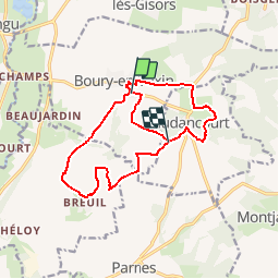
Trail Walking of 13.9 km to be discovered at Hauts-de-France, Oise, Boury-en-Vexin. This trail is proposed by marcel.F.
Description
Boucle fin d'année 9.1 km avec option 12.0 km
Rendez-vous à 9h00 à Etrepagny ou 9h20 au départ devant château de Boury en Vexin (60).
Parcours via Breuil
Positioning
Country:
France
Region :
Hauts-de-France
Department/Province :
Oise
Municipality :
Boury-en-Vexin
Location:
Unknown
Start:(Dec)
Start:(UTM)
408142 ; 5454875 (31U) N.
Comments
Trails nearby
![Trail Walking Boury-en-Vexin - Boury en Vexin - Hérouval - Photo](https://media.geolcdn.com/t/375/260/ext.jpg?maxdim=2&url=https%3A%2F%2Fservices.sitytrail.com%2FGeolivesWS%2FDownloadMedia.ashx%3FTrailID%3D158258%26Media%3D70479d1b-26bd-4332-9afe-06d6c1ec1e96.jpg)
![Walking Walking](https://static1.geolcdn.com/sitytour/trail-icons/101.png)
Boury en Vexin - Hérouval
Walking
Easy
(3)
Boury-en-Vexin,
Hauts-de-France,
Oise,
France
![](/images/other/stat-length.png)
10.9 km | 12.9 km-effort
2h 49min
![](https://static1.geolcdn.com/siteimages/upload/files/16400158638029165_repeat_loop_refresh_sync_direction_icon.png)
Yes
![Trail Walking Vaudancourt - Vaudancourt - Breuil et Boury - Photo](https://media.geolcdn.com/t/375/260/ext.jpg?maxdim=2&url=https%3A%2F%2Fservices.sitytrail.com%2FGeolivesWS%2FDownloadMedia.ashx%3FTrailID%3D157619%26Media%3D1550d1cf-9f43-43fc-88a1-2fb31ebab517.jpg)
![Walking Walking](https://static1.geolcdn.com/sitytour/trail-icons/101.png)
Vaudancourt - Breuil et Boury
Walking
Easy
(1)
Vaudancourt,
Hauts-de-France,
Oise,
France
![](/images/other/stat-length.png)
11.8 km | 14.3 km-effort
3h 5min
![](https://static1.geolcdn.com/siteimages/upload/files/16400158638029165_repeat_loop_refresh_sync_direction_icon.png)
Yes
![Trail Walking Buhy - De Buchet à Magny en Vexin - Photo](https://media.geolcdn.com/t/375/260/1020b94f-166d-40ac-8266-f51a3f0e5d45.jpg&format=jpg&maxdim=2)
![Walking Walking](https://static1.geolcdn.com/sitytour/trail-icons/101.png)
De Buchet à Magny en Vexin
Walking
Medium
Buhy,
Ile-de-France,
Val-d'Oise,
France
![](/images/other/stat-length.png)
25 km | 29 km-effort
5h 3min
![](https://static1.geolcdn.com/siteimages/upload/files/16400158638029165_repeat_loop_refresh_sync_direction_icon.png)
No
![Trail Walking Noyers - Noyers - Vesly et ND du chêne - Photo](https://media.geolcdn.com/t/375/260/ext.jpg?maxdim=2&url=https%3A%2F%2Fstatic1.geolcdn.com%2Fsiteimages%2Fupload%2Ffiles%2F1553511878bg_sport_marche.png)
![Walking Walking](https://static1.geolcdn.com/sitytour/trail-icons/101.png)
Noyers - Vesly et ND du chêne
Walking
Medium
(1)
Noyers,
Normandy,
Eure,
France
![](/images/other/stat-length.png)
13.6 km | 16.5 km-effort
2h 30min
![](https://static1.geolcdn.com/siteimages/upload/files/16400158638029165_repeat_loop_refresh_sync_direction_icon.png)
Yes
![Trail Nordic walking Boury-en-Vexin - Marche Nordique 75 Boury en Vexin - Photo](https://media.geolcdn.com/t/375/260/ext.jpg?maxdim=2&url=https%3A%2F%2Fstatic1.geolcdn.com%2Fsiteimages%2Fupload%2Ffiles%2F1545311037marcheuse_200dpi.jpg)
![Nordic walking Nordic walking](https://static1.geolcdn.com/sitytour/trail-icons/102.png)
Marche Nordique 75 Boury en Vexin
Nordic walking
Easy
(1)
Boury-en-Vexin,
Hauts-de-France,
Oise,
France
![](/images/other/stat-length.png)
10.3 km | 12.6 km-effort
1h 30min
![](https://static1.geolcdn.com/siteimages/upload/files/16400158638029165_repeat_loop_refresh_sync_direction_icon.png)
Yes
![Trail Nordic walking Courcelles-lès-Gisors - Marche Nordique 71 Courcelles les Gisors - Photo](https://media.geolcdn.com/t/375/260/ext.jpg?maxdim=2&url=https%3A%2F%2Fstatic1.geolcdn.com%2Fsiteimages%2Fupload%2Ffiles%2F1545311037marcheuse_200dpi.jpg)
![Nordic walking Nordic walking](https://static1.geolcdn.com/sitytour/trail-icons/102.png)
Marche Nordique 71 Courcelles les Gisors
Nordic walking
Very easy
(2)
Courcelles-lès-Gisors,
Hauts-de-France,
Oise,
France
![](/images/other/stat-length.png)
9.2 km | 10.9 km-effort
1h 26min
![](https://static1.geolcdn.com/siteimages/upload/files/16400158638029165_repeat_loop_refresh_sync_direction_icon.png)
Yes
![Trail Walking Montjavoult - Montjavoult - Vaudancourt - Photo](https://media.geolcdn.com/t/375/260/ext.jpg?maxdim=2&url=https%3A%2F%2Fstatic1.geolcdn.com%2Fsiteimages%2Fupload%2Ffiles%2F1553511878bg_sport_marche.png)
![Walking Walking](https://static1.geolcdn.com/sitytour/trail-icons/101.png)
Montjavoult - Vaudancourt
Walking
Easy
(1)
Montjavoult,
Hauts-de-France,
Oise,
France
![](/images/other/stat-length.png)
10.2 km | 12.2 km-effort
2h 39min
![](https://static1.geolcdn.com/siteimages/upload/files/16400158638029165_repeat_loop_refresh_sync_direction_icon.png)
Yes
![Trail Walking Guerny - Gisancourt - Notre Dame du Chêne - Photo](https://media.geolcdn.com/t/375/260/ext.jpg?maxdim=2&url=https%3A%2F%2Fstatic1.geolcdn.com%2Fsiteimages%2Fupload%2Ffiles%2F1553511878bg_sport_marche.png)
![Walking Walking](https://static1.geolcdn.com/sitytour/trail-icons/101.png)
Gisancourt - Notre Dame du Chêne
Walking
Easy
(2)
Guerny,
Normandy,
Eure,
France
![](/images/other/stat-length.png)
11.6 km | 13.9 km-effort
3h 2min
![](https://static1.geolcdn.com/siteimages/upload/files/16400158638029165_repeat_loop_refresh_sync_direction_icon.png)
Yes
![Trail Walking Parnes - Parnes - La ferme Chaudry - Photo](https://media.geolcdn.com/t/375/260/ext.jpg?maxdim=2&url=https%3A%2F%2Fstatic1.geolcdn.com%2Fsiteimages%2Fupload%2Ffiles%2F1553511878bg_sport_marche.png)
![Walking Walking](https://static1.geolcdn.com/sitytour/trail-icons/101.png)
Parnes - La ferme Chaudry
Walking
Easy
(2)
Parnes,
Hauts-de-France,
Oise,
France
![](/images/other/stat-length.png)
10.4 km | 13 km-effort
2h 49min
![](https://static1.geolcdn.com/siteimages/upload/files/16400158638029165_repeat_loop_refresh_sync_direction_icon.png)
Yes