Trail Walking Saint-André-de-Vézines -  Roques Altès 12 par St André de Vézines  - Photo

Roques Altès 12 par St André de Vézines

© OpenStreetMap contributors
Length
Length
15.1 km
Max alt
Max alt
877 m
Uphill gradient
Uphill gradient
505 m
Km-Effort
Km-Effort  
22 km
Min alt
Min alt
613 m
Downhill gradient
Downhill gradient
518 m
Boucle
Boucle
No
Creation date :
2015-12-28 00:00:00.0
Updated on :
2015-12-28 00:00:00.0

(1 Reviews)

Walking
Walking
5h20
Difficulty : Medium

Scan this QR Code to open this trail in the SityTrail application

FREE GPS app for hiking

Logo SityTrail SityTrail

IGN / Geographical institutes

Download SityTrail from the App Store Download SityTrail from Google Play

Logo SityTrail SityTrail World

The world is yours!

Download SityTrail from the App Store Download SityTrail from Google Play Download SityTrail on Huawei AppGallery

About

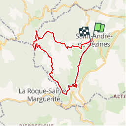
Trail Walking of 15.1 km to be discovered at Occitania, Aveyron, Saint-André-de-Vézines. This trail is proposed by jeanneruols.

Description

Départ :St André de Vézines 12
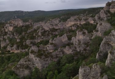
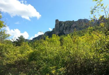
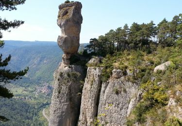
puis prendre le GR 62 A  ; visite des Rochers de Roques Altés , Corniche du Rajol ( GR62) et Montméjean .
Retour  par le plateau

Elevation profile

Positioning

Country:
France
Region :
Occitania
Department/Province :
Aveyron
Municipality :
Saint-André-de-Vézines
Location:
Unknown
Start:(UTM)
520608 ; 4888907 (31T) N.

Comments

Please log in to post a review or rate the element


Trails nearby

Trail Walking Le Rozier - 12 vase de Sèvres Chine ch. brunet - Photo
Walking
GUIDE
randodyssée

Walking

Medium
(1)
Le Rozier, Occitania, Lozère, France
10.1 km | 18.8 km-effort
5h 40min
Yes
Trail Walking Le Rozier - Causse et gorges au pays des vautours  - Photo
Walking
GUIDE
nadinebondoux

Walking

Difficult
Le Rozier, Occitania, Lozère, France
27 km | 40 km-effort
7h 48min
No
Trail Walking La Roque-Sainte-Marguerite - 12 chaos Montpellier le vx roquesaltes - Photo
Walking
GUIDE
randodyssée

Walking

Medium
La Roque-Sainte-Marguerite, Occitania, Aveyron, France
19.6 km | 29 km-effort
7h 38min
Yes
Trail Walking Peyreleau - Grands Causses - Peyreleau - Corniches du Causse Noir- 2016 09 06 - Photo
Walking
GUIDE
Orcal37

Walking

Difficult
Peyreleau, Occitania, Aveyron, France
12.5 km | 21 km-effort
6h 40min
Yes
Trail Walking Veyreau - J3 St Jean des Balmes Ermitage St Michel - Photo
Walking
ARPF

Walking

Easy
(2)
Veyreau, Occitania, Aveyron, France
9.6 km | 13.9 km-effort
3h 18min
Yes
Trail Walking Peyreleau - Grands Causses - Gorges de la Jonte - Peyreleau - Photo
Walking
GUIDE
Orcal37

Walking

Easy
Peyreleau, Occitania, Aveyron, France
9 km | 12.9 km-effort
3h 25min
Yes
Trail Walking Le Rozier - Grands Causses - Causse Méjean - Vautours - Photo
Walking
GUIDE
Orcal37

Walking

Difficult
Le Rozier, Occitania, Lozère, France
12.5 km | 23 km-effort
4h 50min
Yes
Trail Walking Le Rozier - Sur Les Hauteurs De Peyreleau - Photo
Walking
Patakk

Walking

Difficult
(2)
Le Rozier, Occitania, Lozère, France
10.4 km | 18.2 km-effort
4h 0min
Yes
Trail Walking Peyreleau - Le 815 - Peyreleau - Photo
Walking
tracegps

Walking

Easy
(1)
Peyreleau, Occitania, Aveyron, France
5.5 km | 10.5 km-effort
2h 0min
Yes


Close
My subscriptions