![](/images/other/stat-length.png)
![Trail Snowshoes Les Déserts - Boucle Feclaz-Orionde-passage du Croc-Feclaz - Photo](https://media.geolcdn.com/t/1900/400/ext.pjpeg?maxdim=2&url=https%3A%2F%2Fstatic1.geolcdn.com%2Fsiteimages%2Fupload%2Ffiles%2F1524743153raquette.jpg)
Boucle Feclaz-Orionde-passage du Croc-Feclaz
patpounet73
User
![Length](/images/other/stat-length.png)
Length
7.9 km
![Max alt](https://static1.geolcdn.com/siteimages/upload/files/1508320355ic_sort_altitude_max_24dp.png)
Max alt
1528 m
![Uphill gradient](https://static1.geolcdn.com/siteimages/upload/files/1508320355ic_sort_den_pos_24dp.png)
Uphill gradient
262 m
![Km-Effort](/images/other/stat-length.png)
Km-Effort
11.4 km
![Min alt](https://static1.geolcdn.com/siteimages/upload/files/1508320355ic_sort_altitude_min_24dp.png)
Min alt
1291 m
![Downhill gradient](https://static1.geolcdn.com/siteimages/upload/files/1508320355ic_sort_den_neg_24dp.png)
Downhill gradient
261 m
![Boucle](https://static1.geolcdn.com/siteimages/upload/files/16400158638029165_repeat_loop_refresh_sync_direction_icon.png)
Boucle
Yes
Creation date :
2015-11-30 00:00:00.0
Updated on :
2015-11-30 00:00:00.0
![Snowshoes](https://static1.geolcdn.com/sitytour/trail-icons/504.png)
2h11
Difficulty : Easy
![Scan this QR Code to open this trail in the SityTrail application](https://capi.geolives.com/qq0zvz2zws4bq2lad0pu/sitytour/trails/498749/qr.png?size=200)
FREE GPS app for hiking
About
Trail Snowshoes of 7.9 km to be discovered at Auvergne-Rhône-Alpes, Savoy, Les Déserts. This trail is proposed by patpounet73.
Description
Bouche Feclaz-pointe de l'Orionde-passage du Croc (Sire)-Feclaz
/!\\ La trace GPS à la montée passe par la piste de ski de la Feclaz (la station était fermée). Mais le chemin de randonnée classique est proche de la trace GPS.
Positioning
Country:
France
Region :
Auvergne-Rhône-Alpes
Department/Province :
Savoy
Municipality :
Les Déserts
Location:
Unknown
Start:(Dec)
Start:(UTM)
732453 ; 5058830 (31T) N.
Comments
Trails nearby
![Trail Walking Montcel - BAUGES: TOUR DE LA FORET DOMANIALE DU GRAND REVARD - Photo](https://media.geolcdn.com/t/375/260/ext.jpg?maxdim=2&url=https%3A%2F%2Fmedia.geolcdn.com%2Ff%2F2b01686d-4589-4bde-9389-487a67061fc0.jpg)
![Walking Walking](https://static1.geolcdn.com/sitytour/trail-icons/101.png)
BAUGES: TOUR DE LA FORET DOMANIALE DU GRAND REVARD
Walking
Difficult
(1)
Montcel,
Auvergne-Rhône-Alpes,
Savoy,
France
![](/images/other/stat-length.png)
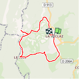
16.6 km | 24 km-effort
5h 15min
![](https://static1.geolcdn.com/siteimages/upload/files/16400158638029165_repeat_loop_refresh_sync_direction_icon.png)
Yes
![Trail Walking Les Déserts - golet de l'agneau - Photo](https://media.geolcdn.com/t/375/260/ext.jpg?maxdim=2&url=https%3A%2F%2Fservices.sitytrail.com%2FGeolivesWS%2FDownloadMedia.ashx%3FTrailID%3D229605%26Media%3Dfix__20131028144817.jpg)
![Walking Walking](https://static1.geolcdn.com/sitytour/trail-icons/101.png)
golet de l'agneau
Walking
Medium
(1)
Les Déserts,
Auvergne-Rhône-Alpes,
Savoy,
France
![](/images/other/stat-length.png)
3.9 km | 10.2 km-effort
1h 44min
![](https://static1.geolcdn.com/siteimages/upload/files/16400158638029165_repeat_loop_refresh_sync_direction_icon.png)
No
![Trail Walking Les Déserts - Circuit de la Croix Nivolet - Photo](https://media.geolcdn.com/t/375/260/ext.jpg?maxdim=2&url=https%3A%2F%2Fstatic1.geolcdn.com%2Fsiteimages%2Fupload%2Ffiles%2F1553511878bg_sport_marche.png)
![Walking Walking](https://static1.geolcdn.com/sitytour/trail-icons/101.png)
Circuit de la Croix Nivolet
Walking
Very easy
(1)
Les Déserts,
Auvergne-Rhône-Alpes,
Savoy,
France
![](/images/other/stat-length.png)
3.5 km | 5.6 km-effort
Unknown
![](https://static1.geolcdn.com/siteimages/upload/files/16400158638029165_repeat_loop_refresh_sync_direction_icon.png)
Yes
![Trail Walking Montcel - BAUGES: PETIT TOUR DE LA FORET DOMANIALE DU REVARD - Photo](https://media.geolcdn.com/t/375/260/ext.jpg?maxdim=2&url=https%3A%2F%2Fstatic1.geolcdn.com%2Fsiteimages%2Fupload%2Ffiles%2F1553511878bg_sport_marche.png)
![Walking Walking](https://static1.geolcdn.com/sitytour/trail-icons/101.png)
BAUGES: PETIT TOUR DE LA FORET DOMANIALE DU REVARD
Walking
Medium
(1)
Montcel,
Auvergne-Rhône-Alpes,
Savoy,
France
![](/images/other/stat-length.png)
12.4 km | 17.2 km-effort
3h 30min
![](https://static1.geolcdn.com/siteimages/upload/files/16400158638029165_repeat_loop_refresh_sync_direction_icon.png)
Yes
![Trail Walking Mouxy - Sentier du Perthuiset - Photo](https://media.geolcdn.com/t/375/260/ext.jpg?maxdim=2&url=https%3A%2F%2Fstatic1.geolcdn.com%2Fsiteimages%2Fupload%2Ffiles%2F1553511878bg_sport_marche.png)
![Walking Walking](https://static1.geolcdn.com/sitytour/trail-icons/101.png)
Sentier du Perthuiset
Walking
Medium
(1)
Mouxy,
Auvergne-Rhône-Alpes,
Savoy,
France
![](/images/other/stat-length.png)
9.4 km | 19.9 km-effort
3h 19min
![](https://static1.geolcdn.com/siteimages/upload/files/16400158638029165_repeat_loop_refresh_sync_direction_icon.png)
Yes
![Trail Walking Les Déserts - Revard : La Féclaz - Photo](https://media.geolcdn.com/t/375/260/ext.jpg?maxdim=2&url=https%3A%2F%2Fstatic1.geolcdn.com%2Fsiteimages%2Fupload%2Ffiles%2F1553511878bg_sport_marche.png)
![Walking Walking](https://static1.geolcdn.com/sitytour/trail-icons/101.png)
Revard : La Féclaz
Walking
Easy
(1)
Les Déserts,
Auvergne-Rhône-Alpes,
Savoy,
France
![](/images/other/stat-length.png)
8.8 km | 10.6 km-effort
2h 22min
![](https://static1.geolcdn.com/siteimages/upload/files/16400158638029165_repeat_loop_refresh_sync_direction_icon.png)
Yes
![Trail Snowshoes Montcel - Le revard la croix des bergers - Photo](https://media.geolcdn.com/t/375/260/ext.jpg?maxdim=2&url=https%3A%2F%2Fmedia.geolcdn.com%2Ff%2F83fe104b-af75-43c8-9085-d2f2b2ade3e5.jpg)
![Snowshoes Snowshoes](https://static1.geolcdn.com/sitytour/trail-icons/504.png)
Le revard la croix des bergers
Snowshoes
Very easy
Montcel,
Auvergne-Rhône-Alpes,
Savoy,
France
![](/images/other/stat-length.png)
6.3 km | 7.9 km-effort
2h 38min
![](https://static1.geolcdn.com/siteimages/upload/files/16400158638029165_repeat_loop_refresh_sync_direction_icon.png)
Yes
![Trail Walking Montcel - MASSIF DES BAUGES: PLATEAU DU REVARD AUTOUR DE LA CROIX DES BERGERS (bis) - Photo](https://media.geolcdn.com/t/375/260/ext.jpg?maxdim=2&url=https%3A%2F%2Fmedia.geolcdn.com%2Ff%2Fec367add-e066-4d39-9029-3b2e73c87a67.jpg)
![Walking Walking](https://static1.geolcdn.com/sitytour/trail-icons/101.png)
MASSIF DES BAUGES: PLATEAU DU REVARD AUTOUR DE LA CROIX DES BERGERS (bis)
Walking
Medium
Montcel,
Auvergne-Rhône-Alpes,
Savoy,
France
![](/images/other/stat-length.png)
12.5 km | 17.9 km-effort
4h 3min
![](https://static1.geolcdn.com/siteimages/upload/files/16400158638029165_repeat_loop_refresh_sync_direction_icon.png)
Yes
![Trail Walking Les Déserts - la croix du Nivollet - Photo](https://media.geolcdn.com/t/375/260/ext.jpg?maxdim=2&url=https%3A%2F%2Fmedia.geolcdn.com%2Ff%2Ff615e6dd-e11c-40da-8fbf-b9a7c0a34f54.jpg)
![Walking Walking](https://static1.geolcdn.com/sitytour/trail-icons/101.png)
la croix du Nivollet
Walking
Easy
Les Déserts,
Auvergne-Rhône-Alpes,
Savoy,
France
![](/images/other/stat-length.png)
12.6 km | 18.6 km-effort
3h 3min
![](https://static1.geolcdn.com/siteimages/upload/files/16400158638029165_repeat_loop_refresh_sync_direction_icon.png)
Yes