Trail Walking Fauch - 81_Fauch - Photo
 jab31
jab31

User

© OpenStreetMap contributors
Length
Length
12.9 km
Max alt
Max alt
356 m
Uphill gradient
Uphill gradient
277 m
Km-Effort
Km-Effort  
16.6 km
Min alt
Min alt
238 m
Downhill gradient
Downhill gradient
276 m
Boucle
Boucle
Yes
Creation date :
2017-11-08 00:00:00.0
Updated on :
2017-11-08 00:00:00.0

(0 Reviews)

Walking
Walking
2h39
Difficulty : Easy

Scan this QR Code to open this trail in the SityTrail application

FREE GPS app for hiking

Logo SityTrail SityTrail

IGN / Geographical institutes

Download SityTrail from the App Store Download SityTrail from Google Play

Logo SityTrail SityTrail World

The world is yours!

Download SityTrail from the App Store Download SityTrail from Google Play Download SityTrail on Huawei AppGallery

About

Trail Walking of 12.9 km to be discovered at Occitania, Tarn, Fauch. This trail is proposed by jab31.

Description

Chemin des puechs d'Assou; campagne et vallée

Elevation profile

Positioning

Country:
France
Region :
Occitania
Department/Province :
Tarn
Municipality :
Fauch
Location:
Unknown
Start:(UTM)
439923 ; 4853524 (31T) N.

Trails nearby

Trail Walking Terre-de-Bancalié - Tour du lac de la bancalié - Photo
Walking
tiki01

Walking

Easy
Terre-de-Bancalié, Occitania, Tarn, France
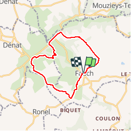
10.2 km | 12.4 km-effort
3h 3min
Yes
Trail Walking Puygouzon - Sentier des Panoramas court - Photo
Walking
jpipacific

Walking

Easy
Puygouzon, Occitania, Tarn, France
8 km | 10.2 km-effort
1h 50min
Yes
Trail Walking Terre-de-Bancalié - prepa fev - Photo
Walking
jpipacific

Walking

Easy
Terre-de-Bancalié, Occitania, Tarn, France
6.4 km | 8.5 km-effort
1h 55min
Yes
Trail Walking Fauch - rando Puechs en Assou Fauch - Photo
Walking
jpipacific

Walking

Medium
Fauch, Occitania, Tarn, France
12.7 km | 16.4 km-effort
2h 38min
Yes
Trail Road bike Dénat - ecole Ronel - Photo
Road bike
Pascal GARNIER

Road bike

Easy
Dénat, Occitania, Tarn, France
7.2 km | 8.6 km-effort
29min
No
Trail On foot Terre-de-Bancalié - track - Photo
On foot
tercla

On foot

Easy
(1)
Terre-de-Bancalié, Occitania, Tarn, France
9.4 km | 12.8 km-effort
Unknown
Yes
Trail Walking Puygouzon - LABASTIDE-DENAT - Photo
Walking
CANON2

Walking

Easy
(1)
Puygouzon, Occitania, Tarn, France
10.5 km | 13.9 km-effort
2h 56min
Yes
Trail Walking Dénat - DENAT L'assou - Photo
Walking
CANON2

Walking

Easy
Dénat, Occitania, Tarn, France
6.2 km | 7.8 km-effort
1h 42min
Yes
Trail Walking Terre-de-Bancalié - Entre vallons et colines - Photo
Walking
CANON2

Walking

Easy
Terre-de-Bancalié, Occitania, Tarn, France
10.1 km | 13.8 km-effort
2h 40min
Yes


Close
My subscriptions