![](/images/other/stat-length.png)
![Trail Mountain bike Besançon - Fort de la Dame Blanche - 26 km (VTT) - Photo](https://media.geolcdn.com/t/1900/400/ext.pjpeg?maxdim=2&url=https%3A%2F%2Fstatic1.geolcdn.com%2Fsiteimages%2Fupload%2Ffiles%2F1524743154velo.jpg)
Fort de la Dame Blanche - 26 km (VTT)
La Maison du Tourisme de Besançon
Randonnées de la Maison du Tourisme de Besançon
![Length](/images/other/stat-length.png)
![Max alt](https://static1.geolcdn.com/siteimages/upload/files/1508320355ic_sort_altitude_max_24dp.png)
![Uphill gradient](https://static1.geolcdn.com/siteimages/upload/files/1508320355ic_sort_den_pos_24dp.png)
![Km-Effort](/images/other/stat-length.png)
![Min alt](https://static1.geolcdn.com/siteimages/upload/files/1508320355ic_sort_altitude_min_24dp.png)
![Downhill gradient](https://static1.geolcdn.com/siteimages/upload/files/1508320355ic_sort_den_neg_24dp.png)
![Boucle](https://static1.geolcdn.com/siteimages/upload/files/16400158638029165_repeat_loop_refresh_sync_direction_icon.png)
![Mountain bike](https://static1.geolcdn.com/sitytour/trail-icons/202.png)
--
Difficulty : Unknown
![Scan this QR Code to open this trail in the SityTrail application](https://capi.geolives.com/qq0zvz2zws4bq2lad0pu/sitytour/trails/49301/qr.png?size=200)
FREE GPS app for hiking
About
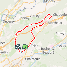
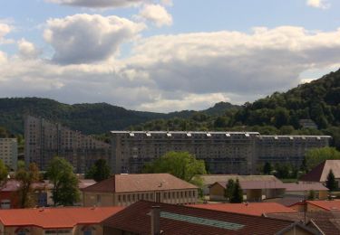
Trail Mountain bike of 26 km to be discovered at Bourgogne-Franche-Comté, Doubs, Besançon. This trail is proposed by La Maison du Tourisme de Besançon .
Description
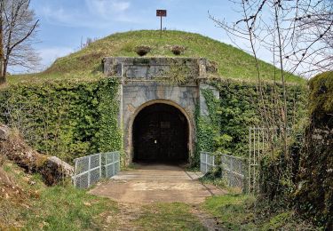
Ce parcours est très varié. Il débute par une partie goudronnée d'environ 3 km pour atteindre le début de la côte. Ensuite la grande montée (6km) se fait sur un chemin en cailloux qui secoue pas mal -prévoir une selle rembourrée- Une fois arrivé au fort, la vue est immense et magnifique. La descente alterne chemins sur herbe, pierres et boue pour finir sur le chemin du retour assez plat. Cette portion du parcours est vraiment très agréable, tout le monde y trouve son bonheur, descentes techniques, singles rapides... Attention aux passages boueux en cas de pluie les jours précédents.
Positioning
Comments
Trails nearby
![Trail Walking Montfaucon - Du chateau au fort de Monfaucon - Photo](https://media.geolcdn.com/t/375/260/ext.jpg?maxdim=2&url=https%3A%2F%2Fservices.sitytrail.com%2FGeolivesWS%2FDownloadMedia.ashx%3FTrailID%3D705744%26Media%3Dfix__20170226154846.jpg)
![Walking Walking](https://static1.geolcdn.com/sitytour/trail-icons/101.png)
Walking
![](/images/other/stat-length.png)
![](https://static1.geolcdn.com/siteimages/upload/files/16400158638029165_repeat_loop_refresh_sync_direction_icon.png)
![Trail Walking Besançon - Colline de Besançon 29-08-2020 - Photo](https://media.geolcdn.com/t/375/260/1e155548-d400-46d3-8b28-207c9933a379.jpg&format=jpg&maxdim=2)
![Walking Walking](https://static1.geolcdn.com/sitytour/trail-icons/101.png)
Walking
![](/images/other/stat-length.png)
![](https://static1.geolcdn.com/siteimages/upload/files/16400158638029165_repeat_loop_refresh_sync_direction_icon.png)
![Trail On foot Montfaucon - Boucle de Nacra - Photo](https://media.geolcdn.com/t/375/260/754b99f9-55b9-4375-839c-408b044dfd0e.jpeg&format=jpg&maxdim=2)
![On foot On foot](https://static1.geolcdn.com/sitytour/trail-icons/100.png)
On foot
![](/images/other/stat-length.png)
![](https://static1.geolcdn.com/siteimages/upload/files/16400158638029165_repeat_loop_refresh_sync_direction_icon.png)
![Trail On foot Montfaucon - Sentier des Falaises et du château - Photo](https://media.geolcdn.com/t/375/260/5325d98d-322b-4b71-b21b-224d670c2150.jpeg&format=jpg&maxdim=2)
![On foot On foot](https://static1.geolcdn.com/sitytour/trail-icons/100.png)
On foot
![](/images/other/stat-length.png)
![](https://static1.geolcdn.com/siteimages/upload/files/16400158638029165_repeat_loop_refresh_sync_direction_icon.png)
![Trail On foot Montfaucon - Sentier du Fort et des Batteries - Photo](https://media.geolcdn.com/t/375/260/465eae89-7ad3-4616-8710-419d54be2030.jpeg&format=jpg&maxdim=2)
![On foot On foot](https://static1.geolcdn.com/sitytour/trail-icons/100.png)
On foot
![](/images/other/stat-length.png)
![](https://static1.geolcdn.com/siteimages/upload/files/16400158638029165_repeat_loop_refresh_sync_direction_icon.png)
![Trail On foot Montfaucon - Sentier des Rives et du Château - Photo](https://media.geolcdn.com/t/375/260/be985a7f-6ff4-4824-a934-7ddceed39444.jpeg&format=jpg&maxdim=2)
![On foot On foot](https://static1.geolcdn.com/sitytour/trail-icons/100.png)
On foot
![](/images/other/stat-length.png)
![](https://static1.geolcdn.com/siteimages/upload/files/16400158638029165_repeat_loop_refresh_sync_direction_icon.png)
![Trail On foot Thise - Sentier du Coutelot - Photo](https://media.geolcdn.com/t/375/260/afb256b5-7789-4ded-ae1d-d84139dab379.jpeg&format=jpg&maxdim=2)
![On foot On foot](https://static1.geolcdn.com/sitytour/trail-icons/100.png)
On foot
![](/images/other/stat-length.png)
![](https://static1.geolcdn.com/siteimages/upload/files/16400158638029165_repeat_loop_refresh_sync_direction_icon.png)
![Trail On foot Besançon - Dame Blanche et Vieux Tilleul - Photo](https://media.geolcdn.com/t/375/260/a831d8ab-a72b-4417-bd94-e54f01ff5dc4.jpeg&format=jpg&maxdim=2)
![On foot On foot](https://static1.geolcdn.com/sitytour/trail-icons/100.png)
On foot
![](/images/other/stat-length.png)
![](https://static1.geolcdn.com/siteimages/upload/files/16400158638029165_repeat_loop_refresh_sync_direction_icon.png)
![Trail On foot Besançon - Circuit du Fort de Chaudanne - Photo](https://media.geolcdn.com/t/375/260/f459fb87-cd43-4e44-8d82-f1846bd50633.jpeg&format=jpg&maxdim=2)
![On foot On foot](https://static1.geolcdn.com/sitytour/trail-icons/100.png)
On foot
![](/images/other/stat-length.png)
![](https://static1.geolcdn.com/siteimages/upload/files/16400158638029165_repeat_loop_refresh_sync_direction_icon.png)