![](/images/other/stat-length.png)
![Trail Cycle Chailly-en-Brie - La vallée du Grand Morin de Coulommiers vers la source - Photo](https://media.geolcdn.com/t/1900/400/ext.pjpeg?maxdim=2&url=https%3A%2F%2Fstatic1.geolcdn.com%2Fsiteimages%2Fupload%2Ffiles%2F1524743154velo.jpg)
La vallée du Grand Morin de Coulommiers vers la source
destras
User
![Length](/images/other/stat-length.png)
Length
121 km
![Max alt](https://static1.geolcdn.com/siteimages/upload/files/1508320355ic_sort_altitude_max_24dp.png)
Max alt
216 m
![Uphill gradient](https://static1.geolcdn.com/siteimages/upload/files/1508320355ic_sort_den_pos_24dp.png)
Uphill gradient
1307 m
![Km-Effort](/images/other/stat-length.png)
Km-Effort
138 km
![Min alt](https://static1.geolcdn.com/siteimages/upload/files/1508320355ic_sort_altitude_min_24dp.png)
Min alt
71 m
![Downhill gradient](https://static1.geolcdn.com/siteimages/upload/files/1508320355ic_sort_den_neg_24dp.png)
Downhill gradient
1305 m
![Boucle](https://static1.geolcdn.com/siteimages/upload/files/16400158638029165_repeat_loop_refresh_sync_direction_icon.png)
Boucle
Yes
Creation date :
2016-03-09 00:00:00.0
Updated on :
2016-03-09 00:00:00.0
![Cycle](https://static1.geolcdn.com/sitytour/trail-icons/200.png)
6h00
Difficulty : Medium
![Scan this QR Code to open this trail in the SityTrail application](https://capi.geolives.com/qq0zvz2zws4bq2lad0pu/sitytour/trails/490716/qr.png?size=200)
FREE GPS app for hiking
About
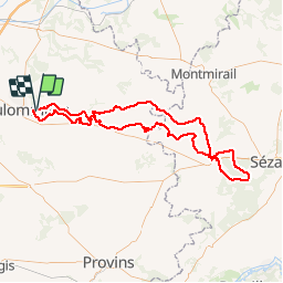
Trail Cycle of 121 km to be discovered at Ile-de-France, Seine-et-Marne, Chailly-en-Brie. This trail is proposed by destras.
Description
Vers la source du Grand Morin en partant de Coulommiers. La rivière se cache on la traverse de nombreuses fois. Très peu de voitures sur ces petites routes.
Positioning
Country:
France
Region :
Ile-de-France
Department/Province :
Seine-et-Marne
Municipality :
Chailly-en-Brie
Location:
Unknown
Start:(Dec)
Start:(UTM)
509113 ; 5406334 (31U) N.
Comments
Trails nearby
![Trail Mountain bike Chailly-en-Brie - Espace VTT FFC - Les Coteaux du Morin et de l'Aubetin - Circuit n° 17 - Boucle1 - Photo](https://media.geolcdn.com/t/375/260/ext.jpg?maxdim=2&url=https%3A%2F%2Fservices.sitytrail.com%2FGeolivesWS%2FDownloadMedia.ashx%3FTrailID%3D104881%26Media%3D8404_4.jpg)
![Mountain bike Mountain bike](https://static1.geolcdn.com/sitytour/trail-icons/202.png)
Espace VTT FFC - Les Coteaux du Morin et de l'Aubetin - Circuit n° 17 - Boucle1
Mountain bike
Difficult
(1)
Chailly-en-Brie,
Ile-de-France,
Seine-et-Marne,
France
![](/images/other/stat-length.png)
50 km | 57 km-effort
4h 30min
![](https://static1.geolcdn.com/siteimages/upload/files/16400158638029165_repeat_loop_refresh_sync_direction_icon.png)
Yes
![Trail Other activity Coulommiers - coulommiers - Photo](https://media.geolcdn.com/t/375/260/ext.jpg?maxdim=2&url=https%3A%2F%2Fservices.sitytrail.com%2FGeolivesWS%2FDownloadMedia.ashx%3FTrailID%3D661376%26Media%3D20161117135808.jpg)
![Other activity Other activity](https://static1.geolcdn.com/sitytour/trail-icons/900.png)
coulommiers
Other activity
Easy
(1)
Coulommiers,
Ile-de-France,
Seine-et-Marne,
France
![](/images/other/stat-length.png)
19 km | 23 km-effort
5h 0min
![](https://static1.geolcdn.com/siteimages/upload/files/16400158638029165_repeat_loop_refresh_sync_direction_icon.png)
Yes
![Trail Walking Coulommiers - COULOMMIERS > FAREMOUTIERS 18 KM - Photo](https://media.geolcdn.com/t/375/260/ext.jpg?maxdim=2&url=https%3A%2F%2Fstatic1.geolcdn.com%2Fsiteimages%2Fupload%2Ffiles%2F1553511878bg_sport_marche.png)
![Walking Walking](https://static1.geolcdn.com/sitytour/trail-icons/101.png)
COULOMMIERS > FAREMOUTIERS 18 KM
Walking
Very easy
(1)
Coulommiers,
Ile-de-France,
Seine-et-Marne,
France
![](/images/other/stat-length.png)
18.2 km | 22 km-effort
4h 40min
![](https://static1.geolcdn.com/siteimages/upload/files/16400158638029165_repeat_loop_refresh_sync_direction_icon.png)
No
![Trail Walking Coulommiers - Commanderie de COULOMMIERS - Photo](https://media.geolcdn.com/t/375/260/ext.jpg?maxdim=2&url=https%3A%2F%2Fstatic1.geolcdn.com%2Fsiteimages%2Fupload%2Ffiles%2F1553511878bg_sport_marche.png)
![Walking Walking](https://static1.geolcdn.com/sitytour/trail-icons/101.png)
Commanderie de COULOMMIERS
Walking
Medium
(3)
Coulommiers,
Ile-de-France,
Seine-et-Marne,
France
![](/images/other/stat-length.png)
12.9 km | 15.4 km-effort
3h 9min
![](https://static1.geolcdn.com/siteimages/upload/files/16400158638029165_repeat_loop_refresh_sync_direction_icon.png)
Yes
![Trail Walking Coulommiers - Coulommiers/Aunoy - Photo](https://media.geolcdn.com/t/375/260/e74aaa5c-c78a-41c1-a9c9-b28f10b2a0b6.jpg&format=jpg&maxdim=2)
![Walking Walking](https://static1.geolcdn.com/sitytour/trail-icons/101.png)
Coulommiers/Aunoy
Walking
Very difficult
Coulommiers,
Ile-de-France,
Seine-et-Marne,
France
![](/images/other/stat-length.png)
23 km | 27 km-effort
5h 21min
![](https://static1.geolcdn.com/siteimages/upload/files/16400158638029165_repeat_loop_refresh_sync_direction_icon.png)
Yes
![Trail Walking Coulommiers - A l'est de Coulommiers - Photo](https://media.geolcdn.com/t/375/260/ext.jpg?maxdim=2&url=https%3A%2F%2Fservices.sitytrail.com%2FGeolivesWS%2FDownloadMedia.ashx%3FTrailID%3D824862%26Media%3Dfix__20170907170809.jpg)
![Walking Walking](https://static1.geolcdn.com/sitytour/trail-icons/101.png)
A l'est de Coulommiers
Walking
Medium
Coulommiers,
Ile-de-France,
Seine-et-Marne,
France
![](/images/other/stat-length.png)
16.5 km | 19.1 km-effort
2h 57min
![](https://static1.geolcdn.com/siteimages/upload/files/16400158638029165_repeat_loop_refresh_sync_direction_icon.png)
Yes
![Trail Walking Coulommiers - A l'Ouest de Coulommiers - Photo](https://media.geolcdn.com/t/375/260/ext.jpg?maxdim=2&url=https%3A%2F%2Fservices.sitytrail.com%2FGeolivesWS%2FDownloadMedia.ashx%3FTrailID%3D820891%26Media%3Dfix__20170831153648.jpg)
![Walking Walking](https://static1.geolcdn.com/sitytour/trail-icons/101.png)
A l'Ouest de Coulommiers
Walking
Easy
Coulommiers,
Ile-de-France,
Seine-et-Marne,
France
![](/images/other/stat-length.png)
12.8 km | 14.6 km-effort
2h 28min
![](https://static1.geolcdn.com/siteimages/upload/files/16400158638029165_repeat_loop_refresh_sync_direction_icon.png)
Yes
![Trail Walking Coulommiers - Au Sud de Coulommiers - Photo](https://media.geolcdn.com/t/375/260/ext.jpg?maxdim=2&url=https%3A%2F%2Fservices.sitytrail.com%2FGeolivesWS%2FDownloadMedia.ashx%3FTrailID%3D816619%26Media%3Dfix__20170824172705.jpg)
![Walking Walking](https://static1.geolcdn.com/sitytour/trail-icons/101.png)
Au Sud de Coulommiers
Walking
Medium
Coulommiers,
Ile-de-France,
Seine-et-Marne,
France
![](/images/other/stat-length.png)
22 km | 24 km-effort
3h 28min
![](https://static1.geolcdn.com/siteimages/upload/files/16400158638029165_repeat_loop_refresh_sync_direction_icon.png)
Yes
![Trail Walking Coulommiers - Visite de Coulommiers - Photo](https://media.geolcdn.com/t/375/260/ext.jpg?maxdim=2&url=https%3A%2F%2Fservices.sitytrail.com%2FGeolivesWS%2FDownloadMedia.ashx%3FTrailID%3D813040%26Media%3D85e66cdd-3b2b-4cca-bfe3-78b9b6903c8e.jpg)
![Walking Walking](https://static1.geolcdn.com/sitytour/trail-icons/101.png)
Visite de Coulommiers
Walking
Very easy
Coulommiers,
Ile-de-France,
Seine-et-Marne,
France
![](/images/other/stat-length.png)
6.8 km | 8 km-effort
1h 41min
![](https://static1.geolcdn.com/siteimages/upload/files/16400158638029165_repeat_loop_refresh_sync_direction_icon.png)
Yes