![](/images/other/stat-length.png)
![Trail Walking Evolène - Evolène, Sasseneire - Photo](https://media.geolcdn.com/t/1900/400/ext.pjpeg?maxdim=2&url=https%3A%2F%2Fstatic1.geolcdn.com%2Fsiteimages%2Fupload%2Ffiles%2F1553511878bg_sport_marche.png)
Evolène, Sasseneire
rpf
User
![Length](/images/other/stat-length.png)
![Max alt](https://static1.geolcdn.com/siteimages/upload/files/1508320355ic_sort_altitude_max_24dp.png)
![Uphill gradient](https://static1.geolcdn.com/siteimages/upload/files/1508320355ic_sort_den_pos_24dp.png)
![Km-Effort](/images/other/stat-length.png)
![Min alt](https://static1.geolcdn.com/siteimages/upload/files/1508320355ic_sort_altitude_min_24dp.png)
![Downhill gradient](https://static1.geolcdn.com/siteimages/upload/files/1508320355ic_sort_den_neg_24dp.png)
![Boucle](https://static1.geolcdn.com/siteimages/upload/files/16400158638029165_repeat_loop_refresh_sync_direction_icon.png)
![Walking](https://static1.geolcdn.com/sitytour/trail-icons/101.png)
6h30
Difficulty : Unknown
![Scan this QR Code to open this trail in the SityTrail application](https://capi.geolives.com/qq0zvz2zws4bq2lad0pu/sitytour/trails/48882/qr.png?size=200)
FREE GPS app for hiking
About
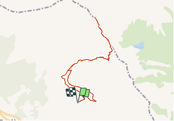
Trail Walking of 9.6 km to be discovered at Valais/Wallis, Hérens, Evolène. This trail is proposed by rpf.
Description
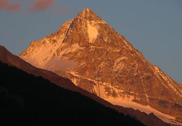
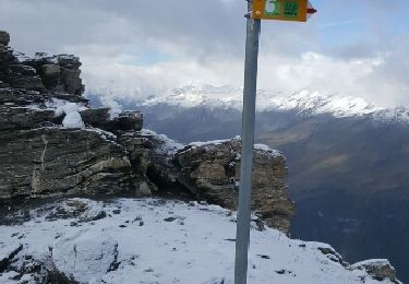
Val d''Hérens, rive droite, Villa, le tout dernier village. Sur le joli sentier du Col de Torrent, qui relie Val d''Hérens et Val d''Anniviers et le chemin de crête assez difficile qui mène au sommet de Sasseneire. Par beau temps, une vue extraordinaire sur la Couronne Impériale, mais les nuages ont eu raison du soleil !
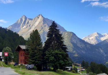
Départ à 2050 mètres aux Mayens de Cotter, au-dessus de La Sage et de Villa.
La route de l''alpage en terre battue monte jusqu''à 2450 mètres, presque jusqu''à Béplan. Elle n''est pas barrée mais est interdite à la circulation.
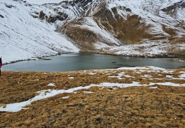
Le dernier tronçon du sentier, entre le Col de Torrent et le sommet de Sasseneire, ne conviendra pas à tout le monde. Les moins "acrobates" pourront s''arrêter au Col, ou au point 3139 pour éviter le dernier passage difficile avant le sommet, ou alors redescendre passer un moment au Lac des Autannes.
Une balade de " www.toprando.ch "
Positioning
Comments
Trails nearby
![Trail On foot Evolène - Tour pédestre du Val d'Hérens - Photo](https://media.geolcdn.com/t/375/260/d60cf38c-77bf-4129-9294-d60e6b1dffc9.jpeg&format=jpg&maxdim=2)
![On foot On foot](https://static1.geolcdn.com/sitytour/trail-icons/100.png)
On foot
![](/images/other/stat-length.png)
![](https://static1.geolcdn.com/siteimages/upload/files/16400158638029165_repeat_loop_refresh_sync_direction_icon.png)
![Trail Walking Anniviers - Grimentz, Cabane de Moiry - Photo](https://media.geolcdn.com/t/375/260/ext.jpg?maxdim=2&url=https%3A%2F%2Fstatic1.geolcdn.com%2Fsiteimages%2Fupload%2Ffiles%2F1553511878bg_sport_marche.png)
![Walking Walking](https://static1.geolcdn.com/sitytour/trail-icons/101.png)
Walking
![](/images/other/stat-length.png)
![](https://static1.geolcdn.com/siteimages/upload/files/16400158638029165_repeat_loop_refresh_sync_direction_icon.png)
![Trail Walking Anniviers - barrage de moiry - Photo](https://media.geolcdn.com/t/375/260/b92986c7-0732-42f4-9954-e3868d779e32.jpg&format=jpg&maxdim=2)
![Walking Walking](https://static1.geolcdn.com/sitytour/trail-icons/101.png)
Walking
![](/images/other/stat-length.png)
![](https://static1.geolcdn.com/siteimages/upload/files/16400158638029165_repeat_loop_refresh_sync_direction_icon.png)
![Trail On foot Evolène - Volvovron - L'A Vieille - Photo](https://media.geolcdn.com/t/375/260/5c03b540-8f8c-485d-804b-53ff835b3e8f.jpeg&format=jpg&maxdim=2)
![On foot On foot](https://static1.geolcdn.com/sitytour/trail-icons/100.png)
On foot
![](/images/other/stat-length.png)
![](https://static1.geolcdn.com/siteimages/upload/files/16400158638029165_repeat_loop_refresh_sync_direction_icon.png)
![Trail On foot Evolène - Cotter - Volvovron - Photo](https://media.geolcdn.com/t/375/260/36ba09c3-e79b-4a55-a676-8e981d39bb91.jpeg&format=jpg&maxdim=2)
![On foot On foot](https://static1.geolcdn.com/sitytour/trail-icons/100.png)
On foot
![](/images/other/stat-length.png)
![](https://static1.geolcdn.com/siteimages/upload/files/16400158638029165_repeat_loop_refresh_sync_direction_icon.png)
![Trail Walking Evolène - CHX ZRMT Étape 7 de La Sage à Zinal - Photo](https://media.geolcdn.com/t/375/260/ext.jpg?maxdim=2&url=https%3A%2F%2Fservices.sitytrail.com%2FGeolivesWS%2FDownloadMedia.ashx%3FTrailID%3D635935%26Media%3Dfix__20160919103137.jpg)
![Walking Walking](https://static1.geolcdn.com/sitytour/trail-icons/101.png)
Walking
![](/images/other/stat-length.png)
![](https://static1.geolcdn.com/siteimages/upload/files/16400158638029165_repeat_loop_refresh_sync_direction_icon.png)
![Trail Walking Evolène - La Haute Route : J6 - Photo](https://media.geolcdn.com/t/375/260/6da9f12a-c8f6-41a8-be78-ed229f95d453.jpg&format=jpg&maxdim=2)
![Walking Walking](https://static1.geolcdn.com/sitytour/trail-icons/101.png)
Walking
![](/images/other/stat-length.png)
![](https://static1.geolcdn.com/siteimages/upload/files/16400158638029165_repeat_loop_refresh_sync_direction_icon.png)
![Trail Walking Evolène - vs_hike674d - Photo](https://media.geolcdn.com/t/375/260/ext.jpg?maxdim=2&url=https%3A%2F%2Fstatic1.geolcdn.com%2Fsiteimages%2Fupload%2Ffiles%2F1553511878bg_sport_marche.png)
![Walking Walking](https://static1.geolcdn.com/sitytour/trail-icons/101.png)
Walking
![](/images/other/stat-length.png)
![](https://static1.geolcdn.com/siteimages/upload/files/16400158638029165_repeat_loop_refresh_sync_direction_icon.png)
![Trail Walking Evolène - bg_tsate - Photo](https://media.geolcdn.com/t/375/260/ext.jpg?maxdim=2&url=https%3A%2F%2Fstatic1.geolcdn.com%2Fsiteimages%2Fupload%2Ffiles%2F1553511878bg_sport_marche.png)
![Walking Walking](https://static1.geolcdn.com/sitytour/trail-icons/101.png)
Walking
![](/images/other/stat-length.png)
![](https://static1.geolcdn.com/siteimages/upload/files/16400158638029165_repeat_loop_refresh_sync_direction_icon.png)