Trail Walking Saint-Martin (VS) - Saint-Martin, Cabane des Becs de Bosson - Photo

Saint-Martin, Cabane des Becs de Bosson

 rpf
rpf

User

© OpenStreetMap contributors
Length
Length
7.2 km
Max alt
Max alt
2971 m
Uphill gradient
Uphill gradient
630 m
Km-Effort
Km-Effort  
15.6 km
Min alt
Min alt
2364 m
Downhill gradient
Downhill gradient
629 m
Boucle
Boucle
Yes
Creation date :
2014-12-10 00:00:00.0
Updated on :
2014-12-10 00:00:00.0

(1 Reviews)

Walking
Walking
4h30
Difficulty : Unknown

Scan this QR Code to open this trail in the SityTrail application

FREE GPS app for hiking

Logo SityTrail SityTrail

IGN / Geographical institutes

Download SityTrail from the App Store Download SityTrail from Google Play

Logo SityTrail SityTrail World

The world is yours!

Download SityTrail from the App Store Download SityTrail from Google Play Download SityTrail on Huawei AppGallery

About

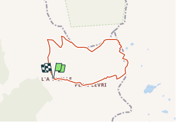
Trail Walking of 7.2 km to be discovered at Valais/Wallis, Hérens, Saint-Martin (VS). This trail is proposed by rpf.

Description

Belle randonnée de début d''automne, avec des vues plongeantes sur le fond "dévasté" du Vallon de Réchy, les Pointes de Tsavolire, la Maya... Des paysages exceptionnels !

Départ de L''A Vieille à 2370 m en direction du Pas de Lona.
Attention! la route en terre nécessite une autorisation communale et peut être fermée à 2100 m par une barrière.
Depuis la Cabane des Becs de Bosson, magnifique parcours sur le chemin de crête entre 2900 et 3000 m.
Retour à L''A Vieille.

Une balade de  " www.toprando.ch "

Elevation profile

Positioning

Country:
Switzerland
Region :
Valais/Wallis
Department/Province :
Hérens
Municipality :
Saint-Martin (VS)
Location:
Unknown
Start:(Dec)
Start:(UTM)
383751 ; 5112311 (32T) N.

Comments

Please log in to post a review or rate the element


Trails nearby

Trail On foot Evolène - Tour pédestre du Val d'Hérens - Photo
On foot
GUIDE+

On foot

Very difficult
Evolène, Valais/Wallis, Hérens, Switzerland
25 km | 49 km-effort
11h 5min
No
Trail On foot Mont-Noble - Le Louché Lac - Col du Cou - Photo
On foot
GUIDE+

On foot

Easy
Mont-Noble, Valais/Wallis, Hérens, Switzerland
3.7 km | 6.3 km-effort
1h 26min
No
Trail On foot Mont-Noble - Le Louché-L'Ar du Tsan Lac (A) - Photo
On foot
GUIDE+

On foot

Easy
Mont-Noble, Valais/Wallis, Hérens, Switzerland
3.6 km | 5 km-effort
1h 8min
No
Trail On foot Evolène - Volvovron - L'A Vieille - Photo
On foot
GUIDE+

On foot

Easy
Evolène, Valais/Wallis, Hérens, Switzerland
4.2 km | 10.3 km-effort
2h 20min
No
Trail On foot Evolène - Cotter - Volvovron - Photo
On foot
GUIDE+

On foot

Easy
Evolène, Valais/Wallis, Hérens, Switzerland
3.4 km | 6.2 km-effort
1h 25min
No
Trail Walking Saint-Martin (VS) - Trajet du 28.10.21 - Photo
Walking
Leemans

Walking

Very difficult
Saint-Martin (VS), Valais/Wallis, Hérens, Switzerland
14.8 km | 28 km-effort
6h 17min
Yes
Trail Walking Mont-Noble - Crêts du Midi au lac Le Louché - Photo
Walking
jpksenicz

Walking

Difficult
Mont-Noble, Valais/Wallis, Hérens, Switzerland
7.3 km | 11.3 km-effort
1h 28min
No
Trail Other activity Anniviers - y10_val_anniviers - Photo
Other activity
GUIDE+

Other activity

Very easy
Anniviers, Valais/Wallis, Sierre, Switzerland
8.1 km | 12.6 km-effort
3h 2min
No
Trail Walking Saint-Martin (VS) - vs_hike674e - Photo
Walking
GUIDE+

Walking

Very easy
Saint-Martin (VS), Valais/Wallis, Hérens, Switzerland
12.5 km | 19 km-effort
3h 4min
No


Close
My subscriptions