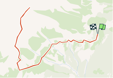
![](/images/other/stat-length.png)
![Trail Walking Fully - Fully, Le Grand Chavalard (par l''Erié) - Photo](https://media.geolcdn.com/t/1900/400/ext.pjpeg?maxdim=2&url=https%3A%2F%2Fstatic1.geolcdn.com%2Fsiteimages%2Fupload%2Ffiles%2F1553511878bg_sport_marche.png)
Fully, Le Grand Chavalard (par l''Erié)
rpf
User
![Length](/images/other/stat-length.png)
![Max alt](https://static1.geolcdn.com/siteimages/upload/files/1508320355ic_sort_altitude_max_24dp.png)
![Uphill gradient](https://static1.geolcdn.com/siteimages/upload/files/1508320355ic_sort_den_pos_24dp.png)
![Km-Effort](/images/other/stat-length.png)
![Min alt](https://static1.geolcdn.com/siteimages/upload/files/1508320355ic_sort_altitude_min_24dp.png)
![Downhill gradient](https://static1.geolcdn.com/siteimages/upload/files/1508320355ic_sort_den_neg_24dp.png)
![Boucle](https://static1.geolcdn.com/siteimages/upload/files/16400158638029165_repeat_loop_refresh_sync_direction_icon.png)
![Walking](https://static1.geolcdn.com/sitytour/trail-icons/101.png)
4h30
Difficulty : Unknown
![Scan this QR Code to open this trail in the SityTrail application](https://capi.geolives.com/qq0zvz2zws4bq2lad0pu/sitytour/trails/48776/qr.png?size=200)
FREE GPS app for hiking
About
Trail Walking of 7.3 km to be discovered at Valais/Wallis, Martigny, Fully. This trail is proposed by rpf.
Description
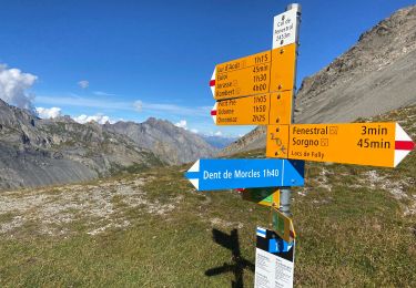
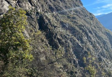
Un rêve !...le sommet du Grand Chavalard ! Dans un amas de roches, à 2900 mètres, avec une vue plongeante de 2500 mètres sur la vallée du Rhône et panorama de toute beauté sur les Alpes calcaires, de la Dent de Morcles à Haut-de-Cry... grandiose !
Départ à "L''Erié", route de Chiboz, après l''alpage de Randonne.
La voie traditionnelle pour le sommet du Grand Chavalard.
Une balade de " www.toprando.ch "
Positioning
Comments
Trails nearby
![Trail On foot Fully - Tour du Grand Chavalard - Photo](https://media.geolcdn.com/t/375/260/dev_67507fd3-861a-4ef5-97f2-010a7f511665.jpeg&format=jpg&maxdim=2)
![On foot On foot](https://static1.geolcdn.com/sitytour/trail-icons/100.png)
On foot
![](/images/other/stat-length.png)
![](https://static1.geolcdn.com/siteimages/upload/files/16400158638029165_repeat_loop_refresh_sync_direction_icon.png)
![Trail Nordic walking Leytron - Ovronaz - Loutze - Ovronaz - Photo](https://media.geolcdn.com/t/375/260/ext.jpg?maxdim=2&url=https%3A%2F%2Fservices.sitytrail.com%2FGeolivesWS%2FDownloadMedia.ashx%3FTrailID%3D246200%26Media%3D20140201124820.jpg)
![Nordic walking Nordic walking](https://static1.geolcdn.com/sitytour/trail-icons/102.png)
Nordic walking
![](/images/other/stat-length.png)
![](https://static1.geolcdn.com/siteimages/upload/files/16400158638029165_repeat_loop_refresh_sync_direction_icon.png)
![Trail Walking Leytron - Cabane Rambert - Photo](https://media.geolcdn.com/t/375/260/ext.jpg?maxdim=2&url=https%3A%2F%2Fservices.sitytrail.com%2FGeolivesWS%2FDownloadMedia.ashx%3FTrailID%3D209855%26Media%3D20130803134530.jpg)
![Walking Walking](https://static1.geolcdn.com/sitytour/trail-icons/101.png)
Walking
![](/images/other/stat-length.png)
![](https://static1.geolcdn.com/siteimages/upload/files/16400158638029165_repeat_loop_refresh_sync_direction_icon.png)
![Trail Walking Leytron - 0vronnaz cabane FENESTRAL - Photo](https://media.geolcdn.com/t/375/260/9e828b15-70d6-4c01-9d2a-591b66af477f.jpg&format=jpg&maxdim=2)
![Walking Walking](https://static1.geolcdn.com/sitytour/trail-icons/101.png)
Walking
![](/images/other/stat-length.png)
![](https://static1.geolcdn.com/siteimages/upload/files/16400158638029165_repeat_loop_refresh_sync_direction_icon.png)
![Trail Walking Saxon - charrat - Photo](https://media.geolcdn.com/t/375/260/0fb1c0ec-d76f-4e80-b50c-5cb298811d98.jpg&format=jpg&maxdim=2)
![Walking Walking](https://static1.geolcdn.com/sitytour/trail-icons/101.png)
![Trail Walking Chamoson - Ovronnaz - Photo](https://media.geolcdn.com/t/375/260/0b175b2c-bdb1-4f39-8772-d1c6dc09dbdc.jpg&format=jpg&maxdim=2)
![Walking Walking](https://static1.geolcdn.com/sitytour/trail-icons/101.png)
Walking
![](/images/other/stat-length.png)
![](https://static1.geolcdn.com/siteimages/upload/files/16400158638029165_repeat_loop_refresh_sync_direction_icon.png)
![Trail On foot Fully - Sentier à travers les âges - Photo](https://media.geolcdn.com/t/375/260/8a1a852d-6a7f-45b3-a0c4-f1dd82397282.jpeg&format=jpg&maxdim=2)
![On foot On foot](https://static1.geolcdn.com/sitytour/trail-icons/100.png)
On foot
![](/images/other/stat-length.png)
![](https://static1.geolcdn.com/siteimages/upload/files/16400158638029165_repeat_loop_refresh_sync_direction_icon.png)
![Trail Walking Fully - fully boudin - Photo](https://media.geolcdn.com/t/375/260/2dc9ab8a-0979-42c4-8309-369498f48caa.jpg&format=jpg&maxdim=2)
![Walking Walking](https://static1.geolcdn.com/sitytour/trail-icons/101.png)
Walking
![](/images/other/stat-length.png)
![](https://static1.geolcdn.com/siteimages/upload/files/16400158638029165_repeat_loop_refresh_sync_direction_icon.png)
![Trail Walking Leytron - Tour d'Ovronaz - Route des bains - Photo](https://media.geolcdn.com/t/375/260/ext.jpg?maxdim=2&url=https%3A%2F%2Fservices.sitytrail.com%2FGeolivesWS%2FDownloadMedia.ashx%3FTrailID%3D596427%26Media%3D3babb666-a844-4fe9-a5e0-8ddcda1a2c0c.jpg)
![Walking Walking](https://static1.geolcdn.com/sitytour/trail-icons/101.png)
Walking
![](/images/other/stat-length.png)
![](https://static1.geolcdn.com/siteimages/upload/files/16400158638029165_repeat_loop_refresh_sync_direction_icon.png)