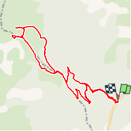
![](/images/other/stat-length.png)
![Trail Walking Auzet - Sommet du Marzenc - Photo](https://media.geolcdn.com/t/1900/400/ext.pjpeg?maxdim=2&url=https%3A%2F%2Fstatic1.geolcdn.com%2Fsiteimages%2Fupload%2Ffiles%2F1553511878bg_sport_marche.png)
Sommet du Marzenc
motardes04
User
![Length](/images/other/stat-length.png)
![Max alt](https://static1.geolcdn.com/siteimages/upload/files/1508320355ic_sort_altitude_max_24dp.png)
![Uphill gradient](https://static1.geolcdn.com/siteimages/upload/files/1508320355ic_sort_den_pos_24dp.png)
![Km-Effort](/images/other/stat-length.png)
![Min alt](https://static1.geolcdn.com/siteimages/upload/files/1508320355ic_sort_altitude_min_24dp.png)
![Downhill gradient](https://static1.geolcdn.com/siteimages/upload/files/1508320355ic_sort_den_neg_24dp.png)
![Boucle](https://static1.geolcdn.com/siteimages/upload/files/16400158638029165_repeat_loop_refresh_sync_direction_icon.png)
![Walking](https://static1.geolcdn.com/sitytour/trail-icons/101.png)
5h01
Difficulty : Medium
![Scan this QR Code to open this trail in the SityTrail application](https://capi.geolives.com/qq0zvz2zws4bq2lad0pu/sitytour/trails/487481/qr.png?size=200)
FREE GPS app for hiking
About
Trail Walking of 13.8 km to be discovered at Provence-Alpes-Côte d'Azur, Alpes-de-Haute-Provence, Auzet. This trail is proposed by motardes04.
Description
Faite le 30/10/2015 -
Rando n°34 du Guide rando des Préalpes de Digne.
Décidément l'auteur de cet ouvrage a une conception de la rando différente de la nôtre, puisqu'il la boucle en 3h30 là où nous avons mis 5h en montant raisonnablement et en prenant le temps de contrôler directions et repères donnés dans le livre (pas très clair sur le hors sentier ou chemins de traverse).
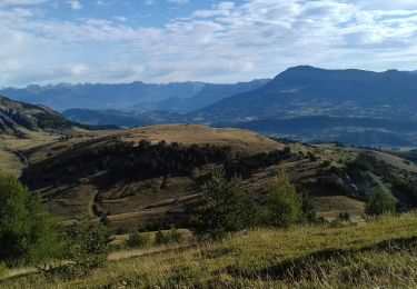
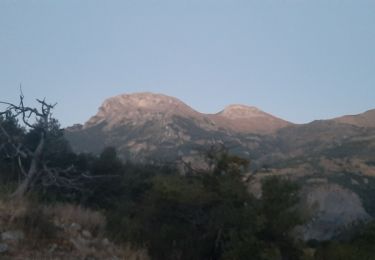
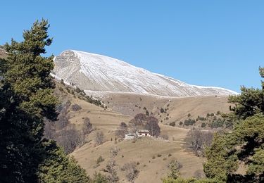
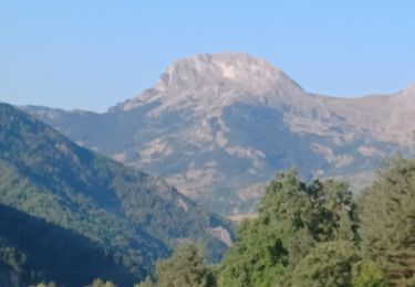
Couleurs magnifiques, jolie vue du sommet sur la Laupie, la montagne de Chine, les cloches de Barles, et de l'autre côté, sur Tête Grosse (Chabanon), Dormillouze (St Jean Monclar), et bien sûr, le Blayeul, géant du secteur.
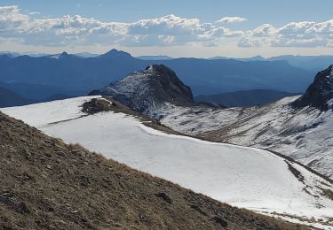
Attention : orientation délicate pour trouver le meilleur moment, hors sentier, pour rejoindre le sommet (mieux vaut suivre la piste, une trace de véhicules permet de monter au sommet).
A la redescente, impossible de trouver l'"ancien sentier" (repère 3h sur le guide) de redescente une fois la piste rejointe (aucun départ 200 mètres après l'épingle ; l'altitude 1500 précisée dans le guide ne correspond pas à ces 200 mètres et à la carte (plutôt 1465 m vérifiés à l'altimètre)... nous avons fait 2 A/R en vain pour trouver le sentier (son aboutissement est en revanche visible du bas, à tenter dans le sens de la montée ?)
Attention enfin en automne : le sentier est glissant à la descente (épais tapis de feuilles mouillées).
Positioning
Comments
Trails nearby
![Trail Walking Auzet - AUZET Le Fanget .Le Clot du Bouc o l s - Photo](https://media.geolcdn.com/t/375/260/dcfc1c1b-ce16-49e9-8c09-defdd504d644.jpg&format=jpg&maxdim=2)
![Walking Walking](https://static1.geolcdn.com/sitytour/trail-icons/101.png)
Walking
![](/images/other/stat-length.png)
![](https://static1.geolcdn.com/siteimages/upload/files/16400158638029165_repeat_loop_refresh_sync_direction_icon.png)
![Trail Walking Barles - BARLES Le Barri AR départ le Bas Moulin o l s - Photo](https://media.geolcdn.com/t/375/260/cc4a106c-cfd4-4655-a8da-47cf56370f9b.jpg&format=jpg&maxdim=2)
![Walking Walking](https://static1.geolcdn.com/sitytour/trail-icons/101.png)
Walking
![](/images/other/stat-length.png)
![](https://static1.geolcdn.com/siteimages/upload/files/16400158638029165_repeat_loop_refresh_sync_direction_icon.png)
![Trail Walking Barles - BARLES Vaux , col de Clapouse , la Laupie. boucle o - Photo](https://media.geolcdn.com/t/375/260/c843e776-1e25-40b9-aafe-ca7db63d170a.jpg&format=jpg&maxdim=2)
![Walking Walking](https://static1.geolcdn.com/sitytour/trail-icons/101.png)
Walking
![](/images/other/stat-length.png)
![](https://static1.geolcdn.com/siteimages/upload/files/16400158638029165_repeat_loop_refresh_sync_direction_icon.png)
![Trail Walking Barles - Cloches de Barles - Photo](https://media.geolcdn.com/t/375/260/ext.jpg?maxdim=2&url=https%3A%2F%2Fstatic1.geolcdn.com%2Fsiteimages%2Fupload%2Ffiles%2F1553511878bg_sport_marche.png)
![Walking Walking](https://static1.geolcdn.com/sitytour/trail-icons/101.png)
Walking
![](/images/other/stat-length.png)
![](https://static1.geolcdn.com/siteimages/upload/files/16400158638029165_repeat_loop_refresh_sync_direction_icon.png)
![Trail Walking Barles - Grande Cloche de Barles - Photo](https://media.geolcdn.com/t/375/260/ext.jpg?maxdim=2&url=https%3A%2F%2Fstatic1.geolcdn.com%2Fsiteimages%2Fupload%2Ffiles%2F1553511878bg_sport_marche.png)
![Walking Walking](https://static1.geolcdn.com/sitytour/trail-icons/101.png)
Walking
![](/images/other/stat-length.png)
![](https://static1.geolcdn.com/siteimages/upload/files/16400158638029165_repeat_loop_refresh_sync_direction_icon.png)
![Trail Walking Auzet - Auzet marzenc 993m 17kms - Photo](https://media.geolcdn.com/t/375/260/9853ba02-1e45-4039-9d76-c79724a3a31a.jpg&format=jpg&maxdim=2)
![Walking Walking](https://static1.geolcdn.com/sitytour/trail-icons/101.png)
Walking
![](/images/other/stat-length.png)
![](https://static1.geolcdn.com/siteimages/upload/files/16400158638029165_repeat_loop_refresh_sync_direction_icon.png)
![Trail Walking Barles - BARLES .TOUR DES CLUES DE VERDACHES O L - Photo](https://media.geolcdn.com/t/375/260/b2aa5727-4b2a-4bb7-ba32-4fb6526da521.jpg&format=jpg&maxdim=2)
![Walking Walking](https://static1.geolcdn.com/sitytour/trail-icons/101.png)
Walking
![](/images/other/stat-length.png)
![](https://static1.geolcdn.com/siteimages/upload/files/16400158638029165_repeat_loop_refresh_sync_direction_icon.png)
![Trail Walking Barles - Chine 14kms 875m - Photo](https://media.geolcdn.com/t/375/260/5461566a-1d2d-4b80-9b71-1def726c1c8f.jpg&format=jpg&maxdim=2)
![Walking Walking](https://static1.geolcdn.com/sitytour/trail-icons/101.png)
Walking
![](/images/other/stat-length.png)
![](https://static1.geolcdn.com/siteimages/upload/files/16400158638029165_repeat_loop_refresh_sync_direction_icon.png)
![Trail Walking Auzet - Col du Fanget - Photo](https://media.geolcdn.com/t/375/260/cf6079d8-6531-4519-888f-9f3fb1a9e26a.jpg&format=jpg&maxdim=2)
![Walking Walking](https://static1.geolcdn.com/sitytour/trail-icons/101.png)
Walking
![](/images/other/stat-length.png)
![](https://static1.geolcdn.com/siteimages/upload/files/16400158638029165_repeat_loop_refresh_sync_direction_icon.png)