![](/images/other/stat-length.png)
![Trail Walking Nogent-sur-Vernisson - Nogent sur Vernisson 10km - Photo](https://media.geolcdn.com/t/1900/400/ext.pjpeg?maxdim=2&url=https%3A%2F%2Fstatic1.geolcdn.com%2Fsiteimages%2Fupload%2Ffiles%2F1553511878bg_sport_marche.png)
Nogent sur Vernisson 10km
picouleau220345
User
![Length](/images/other/stat-length.png)
Length
10.4 km
![Max alt](https://static1.geolcdn.com/siteimages/upload/files/1508320355ic_sort_altitude_max_24dp.png)
Max alt
150 m
![Uphill gradient](https://static1.geolcdn.com/siteimages/upload/files/1508320355ic_sort_den_pos_24dp.png)
Uphill gradient
82 m
![Km-Effort](/images/other/stat-length.png)
Km-Effort
11.5 km
![Min alt](https://static1.geolcdn.com/siteimages/upload/files/1508320355ic_sort_altitude_min_24dp.png)
Min alt
119 m
![Downhill gradient](https://static1.geolcdn.com/siteimages/upload/files/1508320355ic_sort_den_neg_24dp.png)
Downhill gradient
83 m
![Boucle](https://static1.geolcdn.com/siteimages/upload/files/16400158638029165_repeat_loop_refresh_sync_direction_icon.png)
Boucle
Yes
Creation date :
2015-10-22 00:00:00.0
Updated on :
2015-10-22 00:00:00.0
![Walking](https://static1.geolcdn.com/sitytour/trail-icons/101.png)
2h10
Difficulty : Easy
![Scan this QR Code to open this trail in the SityTrail application](https://capi.geolives.com/qq0zvz2zws4bq2lad0pu/sitytour/trails/484640/qr.png?size=200)
FREE GPS app for hiking
About
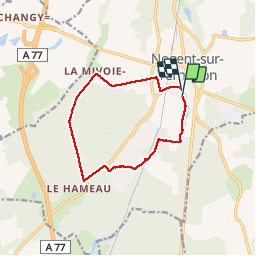
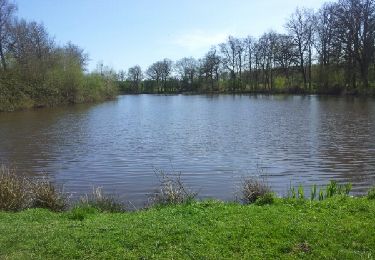
Trail Walking of 10.4 km to be discovered at Centre-Loire Valley, Loiret, Nogent-sur-Vernisson. This trail is proposed by picouleau220345.
Description
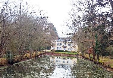
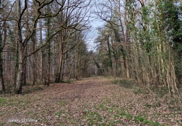
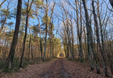
depart etang m,les Barillons , le Château de Bellevue , Domaine de Baugè , pasage dans les bois .chateau de la Mivoie . Parcours possible a toute epoque . Trés bon chemin
Positioning
Country:
France
Region :
Centre-Loire Valley
Department/Province :
Loiret
Municipality :
Nogent-sur-Vernisson
Location:
Unknown
Start:(Dec)
Start:(UTM)
480583 ; 5298546 (31T) N.
Comments
Trails nearby
![Trail Walking Nogent-sur-Vernisson - Pr des cyprès chauves - Photo](https://media.geolcdn.com/t/375/260/ext.jpg?maxdim=2&url=https%3A%2F%2Fservices.sitytrail.com%2FGeolivesWS%2FDownloadMedia.ashx%3FTrailID%3D717837%26Media%3Dfeb5993d-6470-461b-a604-fd4cb640206a.jpg)
![Walking Walking](https://static1.geolcdn.com/sitytour/trail-icons/101.png)
Pr des cyprès chauves
Walking
Easy
Nogent-sur-Vernisson,
Centre-Loire Valley,
Loiret,
France
![](/images/other/stat-length.png)
14.2 km | 15.4 km-effort
3h 24min
![](https://static1.geolcdn.com/siteimages/upload/files/16400158638029165_repeat_loop_refresh_sync_direction_icon.png)
Yes
![Trail Walking Nogent-sur-Vernisson - Nogent 45 - Photo](https://media.geolcdn.com/t/375/260/ext.jpg?maxdim=2&url=https%3A%2F%2Fmedia.geolcdn.com%2Ff%2F070f023c-01ad-4bdb-bbc6-0a83ef2c7975.jpg)
![Walking Walking](https://static1.geolcdn.com/sitytour/trail-icons/101.png)
Nogent 45
Walking
Difficult
Nogent-sur-Vernisson,
Centre-Loire Valley,
Loiret,
France
![](/images/other/stat-length.png)
10.8 km | 12.1 km-effort
2h 48min
![](https://static1.geolcdn.com/siteimages/upload/files/16400158638029165_repeat_loop_refresh_sync_direction_icon.png)
Yes
![Trail Walking Nogent-sur-Vernisson - les Barres 45 Nogent sur Vernisson - Photo](https://media.geolcdn.com/t/375/260/ext.jpg?maxdim=2&url=https%3A%2F%2Fmedia.geolcdn.com%2Ff%2F59030d1f-2f3a-44a2-b4f2-6391748589a2.jpg)
![Walking Walking](https://static1.geolcdn.com/sitytour/trail-icons/101.png)
les Barres 45 Nogent sur Vernisson
Walking
Medium
Nogent-sur-Vernisson,
Centre-Loire Valley,
Loiret,
France
![](/images/other/stat-length.png)
10.4 km | 11.8 km-effort
2h 17min
![](https://static1.geolcdn.com/siteimages/upload/files/16400158638029165_repeat_loop_refresh_sync_direction_icon.png)
No
![Trail Walking Ouzouer-des-Champs - ouzouer des champ 45 - Photo](https://media.geolcdn.com/t/375/260/ext.jpg?maxdim=2&url=https%3A%2F%2Fmedia.geolcdn.com%2Ff%2F7eff70fd-d005-454b-8c99-e65f328b3ce9.jpg)
![Walking Walking](https://static1.geolcdn.com/sitytour/trail-icons/101.png)
ouzouer des champ 45
Walking
Easy
Ouzouer-des-Champs,
Centre-Loire Valley,
Loiret,
France
![](/images/other/stat-length.png)
28 km | 30 km-effort
2h 42min
![](https://static1.geolcdn.com/siteimages/upload/files/16400158638029165_repeat_loop_refresh_sync_direction_icon.png)
No
![Trail Other activity Les Choux - les Choux 45 12km9 - Photo](https://media.geolcdn.com/t/375/260/ext.jpg?maxdim=2&url=https%3A%2F%2Fservices.sitytrail.com%2FGeolivesWS%2FDownloadMedia.ashx%3FTrailID%3D498107%26Media%3Dfix__20150415160639.jpg)
![Other activity Other activity](https://static1.geolcdn.com/sitytour/trail-icons/900.png)
les Choux 45 12km9
Other activity
Very easy
Les Choux,
Centre-Loire Valley,
Loiret,
France
![](/images/other/stat-length.png)
12.9 km | 14.2 km-effort
2h 34min
![](https://static1.geolcdn.com/siteimages/upload/files/16400158638029165_repeat_loop_refresh_sync_direction_icon.png)
Yes
![Trail On foot Pressigny-les-Pins - Pr des Barbiers - Photo](https://media.geolcdn.com/t/375/260/ext.jpg?maxdim=2&url=https%3A%2F%2Fstatic1.geolcdn.com%2Fsiteimages%2Fupload%2Ffiles%2F1545311037marcheuse_200dpi.jpg)
![On foot On foot](https://static1.geolcdn.com/sitytour/trail-icons/100.png)
Pr des Barbiers
On foot
Easy
Pressigny-les-Pins,
Centre-Loire Valley,
Loiret,
France
![](/images/other/stat-length.png)
8.2 km | 8.9 km-effort
2h 1min
![](https://static1.geolcdn.com/siteimages/upload/files/16400158638029165_repeat_loop_refresh_sync_direction_icon.png)
Yes
![Trail Walking Nogent-sur-Vernisson - pr du cèdre bleu - Photo](https://media.geolcdn.com/t/375/260/ext.jpg?maxdim=2&url=https%3A%2F%2Fstatic1.geolcdn.com%2Fsiteimages%2Fupload%2Ffiles%2F1553511878bg_sport_marche.png)
![Walking Walking](https://static1.geolcdn.com/sitytour/trail-icons/101.png)
pr du cèdre bleu
Walking
Very easy
Nogent-sur-Vernisson,
Centre-Loire Valley,
Loiret,
France
![](/images/other/stat-length.png)
10.6 km | 11.7 km-effort
2h 20min
![](https://static1.geolcdn.com/siteimages/upload/files/16400158638029165_repeat_loop_refresh_sync_direction_icon.png)
Yes
![Trail Walking Nogent-sur-Vernisson - autours de l'arboretum - Photo](https://media.geolcdn.com/t/375/260/ext.jpg?maxdim=2&url=https%3A%2F%2Fstatic1.geolcdn.com%2Fsiteimages%2Fupload%2Ffiles%2F1553511878bg_sport_marche.png)
![Walking Walking](https://static1.geolcdn.com/sitytour/trail-icons/101.png)
autours de l'arboretum
Walking
Very easy
Nogent-sur-Vernisson,
Centre-Loire Valley,
Loiret,
France
![](/images/other/stat-length.png)
7.2 km | 8.2 km-effort
2h 23min
![](https://static1.geolcdn.com/siteimages/upload/files/16400158638029165_repeat_loop_refresh_sync_direction_icon.png)
No