![](/images/other/stat-length.png)
![Trail Walking Tourneville - Tourneville - Photo](https://media.geolcdn.com/t/1900/400/ext.pjpeg?maxdim=2&url=https%3A%2F%2Fstatic1.geolcdn.com%2Fsiteimages%2Fupload%2Ffiles%2F1553511878bg_sport_marche.png)
Tourneville
BaladesEN
User
![Length](/images/other/stat-length.png)
Length
12.7 km
![Max alt](https://static1.geolcdn.com/siteimages/upload/files/1508320355ic_sort_altitude_max_24dp.png)
Max alt
146 m
![Uphill gradient](https://static1.geolcdn.com/siteimages/upload/files/1508320355ic_sort_den_pos_24dp.png)
Uphill gradient
195 m
![Km-Effort](/images/other/stat-length.png)
Km-Effort
15.3 km
![Min alt](https://static1.geolcdn.com/siteimages/upload/files/1508320355ic_sort_altitude_min_24dp.png)
Min alt
40 m
![Downhill gradient](https://static1.geolcdn.com/siteimages/upload/files/1508320355ic_sort_den_neg_24dp.png)
Downhill gradient
194 m
![Boucle](https://static1.geolcdn.com/siteimages/upload/files/16400158638029165_repeat_loop_refresh_sync_direction_icon.png)
Boucle
Yes
Creation date :
2015-10-19 00:00:00.0
Updated on :
2015-10-19 00:00:00.0
![Walking](https://static1.geolcdn.com/sitytour/trail-icons/101.png)
3h20
Difficulty : Easy
![Scan this QR Code to open this trail in the SityTrail application](https://capi.geolives.com/qq0zvz2zws4bq2lad0pu/sitytour/trails/483396/qr.png?size=200)
FREE GPS app for hiking
About
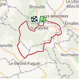
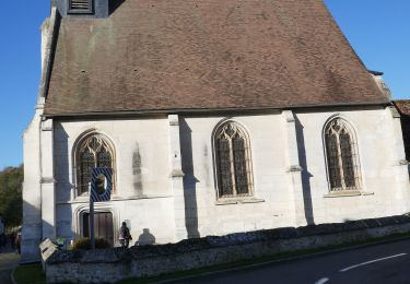
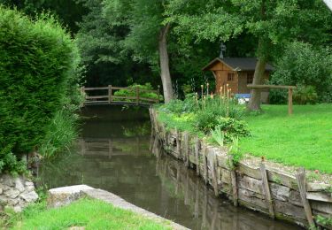
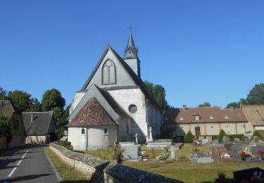
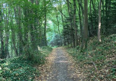
Trail Walking of 12.7 km to be discovered at Normandy, Eure, Tourneville. This trail is proposed by BaladesEN.
Description
Cette randonnée nous propose une boucle qui commence dans la vallée de l'Iton de Tourneville à St-Germain-des-Angles, puis monte sur le plateau boisé du Mesnil-Fuguet, et redescend enfin en suivant le GR26 et l'une de ses variantes. BaladesEnNormandie.fr
Positioning
Country:
France
Region :
Normandy
Department/Province :
Eure
Municipality :
Tourneville
Location:
Unknown
Start:(Dec)
Start:(UTM)
362521 ; 5439965 (31U) N.
Comments
Trails nearby
![Trail Other activity Sacquenville - platiton - Photo](https://media.geolcdn.com/t/375/260/ext.jpg?maxdim=2&url=https%3A%2F%2Fstatic1.geolcdn.com%2Fsiteimages%2Fupload%2Ffiles%2F1545311037marcheuse_200dpi.jpg)
![Other activity Other activity](https://static1.geolcdn.com/sitytour/trail-icons/900.png)
platiton
Other activity
Medium
(1)
Sacquenville,
Normandy,
Eure,
France
![](/images/other/stat-length.png)
22 km | 28 km-effort
5min
![](https://static1.geolcdn.com/siteimages/upload/files/16400158638029165_repeat_loop_refresh_sync_direction_icon.png)
Yes
![On foot On foot](https://static1.geolcdn.com/sitytour/trail-icons/100.png)
normanville
On foot
Very easy
Normanville,
Normandy,
Eure,
France
![](/images/other/stat-length.png)
9.1 km | 10.9 km-effort
Unknown
![](https://static1.geolcdn.com/siteimages/upload/files/16400158638029165_repeat_loop_refresh_sync_direction_icon.png)
Yes
![Trail Walking Tourneville - autrebocs - Photo](https://media.geolcdn.com/t/375/260/ext.jpg?maxdim=2&url=https%3A%2F%2Fstatic1.geolcdn.com%2Fsiteimages%2Fupload%2Ffiles%2F1553511878bg_sport_marche.png)
![Walking Walking](https://static1.geolcdn.com/sitytour/trail-icons/101.png)
autrebocs
Walking
Very easy
(1)
Tourneville,
Normandy,
Eure,
France
![](/images/other/stat-length.png)
11.7 km | 14.7 km-effort
3h 26min
![](https://static1.geolcdn.com/siteimages/upload/files/16400158638029165_repeat_loop_refresh_sync_direction_icon.png)
No
![Trail Walking Sacquenville - Autrebosc Brosville - Photo](https://media.geolcdn.com/t/375/260/ext.jpg?maxdim=2&url=https%3A%2F%2Fstatic1.geolcdn.com%2Fsiteimages%2Fupload%2Ffiles%2F1553511878bg_sport_marche.png)
![Walking Walking](https://static1.geolcdn.com/sitytour/trail-icons/101.png)
Autrebosc Brosville
Walking
Very easy
(1)
Sacquenville,
Normandy,
Eure,
France
![](/images/other/stat-length.png)
9.1 km | 11.4 km-effort
1h 30min
![](https://static1.geolcdn.com/siteimages/upload/files/16400158638029165_repeat_loop_refresh_sync_direction_icon.png)
No
![Trail Walking Normanville - Circuit de Normanville - Photo](https://media.geolcdn.com/t/375/260/ext.jpg?maxdim=2&url=https%3A%2F%2Fstatic1.geolcdn.com%2Fsiteimages%2Fupload%2Ffiles%2F1553511878bg_sport_marche.png)
![Walking Walking](https://static1.geolcdn.com/sitytour/trail-icons/101.png)
Circuit de Normanville
Walking
Medium
(4)
Normanville,
Normandy,
Eure,
France
![](/images/other/stat-length.png)
13 km | 16.5 km-effort
4h 26min
![](https://static1.geolcdn.com/siteimages/upload/files/16400158638029165_repeat_loop_refresh_sync_direction_icon.png)
Yes
![Trail Mountain bike Brosville - Autour de Brosville - Photo](https://media.geolcdn.com/t/375/260/ext.jpg?maxdim=2&url=https%3A%2F%2Fservices.sitytrail.com%2FGeolivesWS%2FDownloadMedia.ashx%3FTrailID%3D102591%26Media%3D3502_6.jpg)
![Mountain bike Mountain bike](https://static1.geolcdn.com/sitytour/trail-icons/202.png)
Autour de Brosville
Mountain bike
Difficult
Brosville,
Normandy,
Eure,
France
![](/images/other/stat-length.png)
32 km | 39 km-effort
3h 0min
![](https://static1.geolcdn.com/siteimages/upload/files/16400158638029165_repeat_loop_refresh_sync_direction_icon.png)
Yes
![Walking Walking](https://static1.geolcdn.com/sitytour/trail-icons/101.png)
20230607-Normanville
Walking
Medium
Normanville,
Normandy,
Eure,
France
![](/images/other/stat-length.png)
19.9 km | 24 km-effort
5h 6min
![](https://static1.geolcdn.com/siteimages/upload/files/16400158638029165_repeat_loop_refresh_sync_direction_icon.png)
Yes
![Trail Walking Tourneville - Vallée de l’Iton 1 - Photo](https://media.geolcdn.com/t/375/260/f580ca96-5dd5-4088-a0ce-f92cf13e4c4a.jpg&format=jpg&maxdim=2)
![Walking Walking](https://static1.geolcdn.com/sitytour/trail-icons/101.png)
Vallée de l’Iton 1
Walking
Medium
Tourneville,
Normandy,
Eure,
France
![](/images/other/stat-length.png)
10.8 km | 14.6 km-effort
3h 3min
![](https://static1.geolcdn.com/siteimages/upload/files/16400158638029165_repeat_loop_refresh_sync_direction_icon.png)
Yes
![Trail Walking Normanville - Normanville - Emalleville - Photo](https://media.geolcdn.com/t/375/260/59fa3af5-299b-49ba-b650-9e2180e44cc5.jpg&format=jpg&maxdim=2)
![Walking Walking](https://static1.geolcdn.com/sitytour/trail-icons/101.png)
Normanville - Emalleville
Walking
Medium
Normanville,
Normandy,
Eure,
France
![](/images/other/stat-length.png)
8.7 km | 10.5 km-effort
2h 23min
![](https://static1.geolcdn.com/siteimages/upload/files/16400158638029165_repeat_loop_refresh_sync_direction_icon.png)
Yes