![](/images/other/stat-length.png)
20151009 Aubel Aachen
Yeyette VTT team
Plus vî, plus sot
![Length](/images/other/stat-length.png)
Length
46 km
![Max alt](https://static1.geolcdn.com/siteimages/upload/files/1508320355ic_sort_altitude_max_24dp.png)
Max alt
351 m
![Uphill gradient](https://static1.geolcdn.com/siteimages/upload/files/1508320355ic_sort_den_pos_24dp.png)
Uphill gradient
873 m
![Km-Effort](/images/other/stat-length.png)
Km-Effort
58 km
![Min alt](https://static1.geolcdn.com/siteimages/upload/files/1508320355ic_sort_altitude_min_24dp.png)
Min alt
114 m
![Downhill gradient](https://static1.geolcdn.com/siteimages/upload/files/1508320355ic_sort_den_neg_24dp.png)
Downhill gradient
899 m
![Boucle](https://static1.geolcdn.com/siteimages/upload/files/16400158638029165_repeat_loop_refresh_sync_direction_icon.png)
Boucle
No
Creation date :
2015-10-12 00:00:00.0
Updated on :
2015-10-12 00:00:00.0
![Mountain bike](https://static1.geolcdn.com/sitytour/trail-icons/202.png)
3h46
Difficulty : Medium
![Scan this QR Code to open this trail in the SityTrail application](https://capi.geolives.com/qq0zvz2zws4bq2lad0pu/sitytour/trails/481271/qr.png?size=200)
FREE GPS app for hiking
About
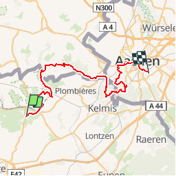
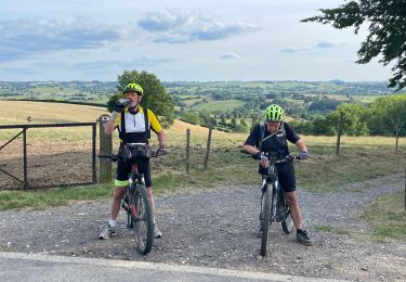
Trail Mountain bike of 46 km to be discovered at Wallonia, Liège, Aubel. This trail is proposed by Yeyette VTT team.
Description
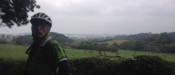
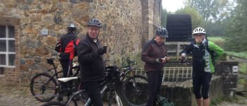
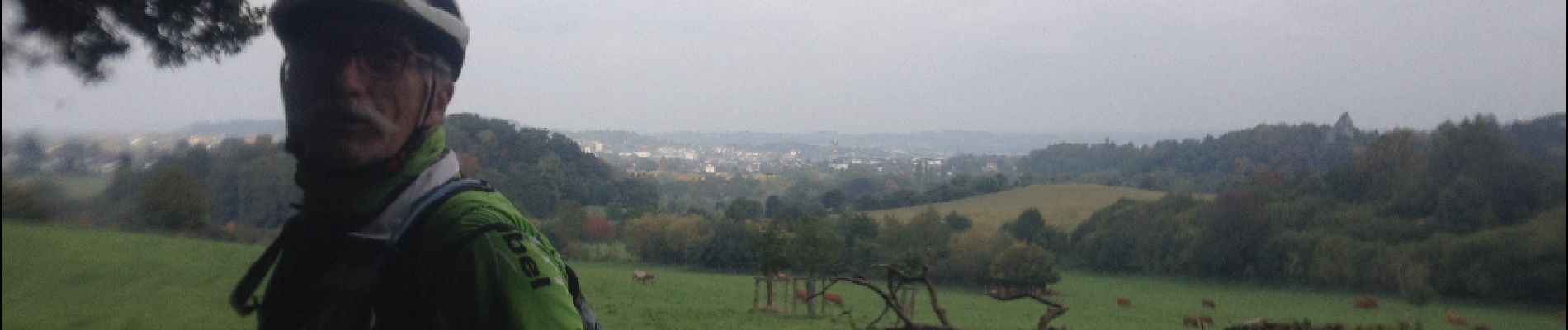
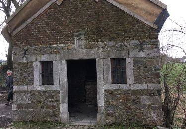
Première journée d'un parcours inédit, merveilleusement tracé par Benoît et son équipe topographique. Raboté par la double crevaison de Nanard.
Positioning
Country:
Belgium
Region :
Wallonia
Department/Province :
Liège
Municipality :
Aubel
Location:
Aubel
Start:(Dec)
Start:(UTM)
701990 ; 5620872 (31U) N.
Comments
Trails nearby
![Trail Walking Plombières - Hombourg. Natura 2000, des sites qui valent le détour ! Lg6 - Photo](https://media.geolcdn.com/t/375/260/ext.jpg?maxdim=2&url=https%3A%2F%2Fservices.sitytrail.com%2FGeolivesWS%2FDownloadMedia.ashx%3FTrailID%3D142693%26Media%3D08dbd372-9409-44af-92fd-51b9576d1e78.JPG)
![Walking Walking](https://static1.geolcdn.com/sitytour/trail-icons/101.png)
Hombourg. Natura 2000, des sites qui valent le détour ! Lg6
Walking
Easy
(10)
Plombières,
Wallonia,
Liège,
Belgium
![](/images/other/stat-length.png)
9.5 km | 12 km-effort
2h 35min
![](https://static1.geolcdn.com/siteimages/upload/files/16400158638029165_repeat_loop_refresh_sync_direction_icon.png)
Yes
![Trail Walking Aubel - autour de val dieu - Photo](https://media.geolcdn.com/t/375/260/fd89e5f6-352d-4ec8-ac99-e9175fe8e322.jpg&format=jpg&maxdim=2)
![Walking Walking](https://static1.geolcdn.com/sitytour/trail-icons/101.png)
autour de val dieu
Walking
Very easy
(6)
Aubel,
Wallonia,
Liège,
Belgium
![](/images/other/stat-length.png)
9.5 km | 12.1 km-effort
2h 13min
![](https://static1.geolcdn.com/siteimages/upload/files/16400158638029165_repeat_loop_refresh_sync_direction_icon.png)
Yes
![Trail Walking Thimister-Clermont - La Minerie - Photo](https://media.geolcdn.com/t/375/260/ext.jpg?maxdim=2&url=https%3A%2F%2Fstatic1.geolcdn.com%2Fsiteimages%2Fupload%2Ffiles%2F1553511878bg_sport_marche.png)
![Walking Walking](https://static1.geolcdn.com/sitytour/trail-icons/101.png)
La Minerie
Walking
Easy
(6)
Thimister-Clermont,
Wallonia,
Liège,
Belgium
![](/images/other/stat-length.png)
12.9 km | 15.7 km-effort
3h 22min
![](https://static1.geolcdn.com/siteimages/upload/files/16400158638029165_repeat_loop_refresh_sync_direction_icon.png)
Yes
![Trail Walking Thimister-Clermont - Froidthier - Photo](https://media.geolcdn.com/t/375/260/9142f7fe-feb5-4533-8005-65992f1c4338.jpg&format=jpg&maxdim=2)
![Walking Walking](https://static1.geolcdn.com/sitytour/trail-icons/101.png)
Froidthier
Walking
Easy
(1)
Thimister-Clermont,
Wallonia,
Liège,
Belgium
![](/images/other/stat-length.png)
6.6 km | 7.9 km-effort
1h 48min
![](https://static1.geolcdn.com/siteimages/upload/files/16400158638029165_repeat_loop_refresh_sync_direction_icon.png)
Yes
![Trail Walking Voeren - La Commanderie 7 - Photo](https://media.geolcdn.com/t/375/260/e2b67305-0779-4cca-9070-82e3402cc790.jpg&format=jpg&maxdim=2)
![Walking Walking](https://static1.geolcdn.com/sitytour/trail-icons/101.png)
La Commanderie 7
Walking
Easy
(1)
Voeren,
Flanders,
Limburg,
Belgium
![](/images/other/stat-length.png)
4.5 km | 6.3 km-effort
1h 26min
![](https://static1.geolcdn.com/siteimages/upload/files/16400158638029165_repeat_loop_refresh_sync_direction_icon.png)
Yes
![Trail Walking Thimister-Clermont - 2021-03-21_09h09m37_1413 - Photo](https://media.geolcdn.com/t/375/260/2cdc1fed-57d0-4e96-9f7c-8bfb9eab2451.jpg&format=jpg&maxdim=2)
![Walking Walking](https://static1.geolcdn.com/sitytour/trail-icons/101.png)
2021-03-21_09h09m37_1413
Walking
Easy
(2)
Thimister-Clermont,
Wallonia,
Liège,
Belgium
![](/images/other/stat-length.png)
11.1 km | 13.6 km-effort
3h 5min
![](https://static1.geolcdn.com/siteimages/upload/files/16400158638029165_repeat_loop_refresh_sync_direction_icon.png)
Yes
![Trail Walking Aubel - RB-Lg-04 - Raccourci - À travers le bocage aubelois - Photo](https://media.geolcdn.com/t/375/260/ext.jpg?maxdim=2&url=https%3A%2F%2Fservices.sitytrail.com%2FGeolivesWS%2FDownloadMedia.ashx%3FTrailID%3D209393%26Media%3D9ac6c0af-9a08-4948-b5d5-06a09e8ba132.jpg)
![Walking Walking](https://static1.geolcdn.com/sitytour/trail-icons/101.png)
RB-Lg-04 - Raccourci - À travers le bocage aubelois
Walking
Medium
(4)
Aubel,
Wallonia,
Liège,
Belgium
![](/images/other/stat-length.png)
17.1 km | 22 km-effort
4h 50min
![](https://static1.geolcdn.com/siteimages/upload/files/16400158638029165_repeat_loop_refresh_sync_direction_icon.png)
Yes
![Trail Mountain bike Aubel - 20220727 Yeyette à Gorhez - Photo](https://media.geolcdn.com/t/375/260/3e91e36a-9872-4e44-80fe-5903cdab6ed3.jpg&format=jpg&maxdim=2)
![Mountain bike Mountain bike](https://static1.geolcdn.com/sitytour/trail-icons/202.png)
20220727 Yeyette à Gorhez
Mountain bike
Medium
(1)
Aubel,
Wallonia,
Liège,
Belgium
![](/images/other/stat-length.png)
33 km | 41 km-effort
2h 33min
![](https://static1.geolcdn.com/siteimages/upload/files/16400158638029165_repeat_loop_refresh_sync_direction_icon.png)
Yes
![Trail Other activity Aubel - val-dieu - Photo](https://media.geolcdn.com/t/375/260/ext.jpg?maxdim=2&url=https%3A%2F%2Fservices.sitytrail.com%2FGeolivesWS%2FDownloadMedia.ashx%3FTrailID%3D716878%26Media%3D20170319144615.jpg)
![Other activity Other activity](https://static1.geolcdn.com/sitytour/trail-icons/900.png)
val-dieu
Other activity
Medium
(1)
Aubel,
Wallonia,
Liège,
Belgium
![](/images/other/stat-length.png)
9.6 km | 12.5 km-effort
2h 16min
![](https://static1.geolcdn.com/siteimages/upload/files/16400158638029165_repeat_loop_refresh_sync_direction_icon.png)
Yes