Trail Walking Cangas de Onís - Cangas de Onis - Photo
 Papamoju
Papamoju

User

© OpenStreetMap contributors
Length
Length
2.5 km
Max alt
Max alt
73 m
Uphill gradient
Uphill gradient
25 m
Km-Effort
Km-Effort  
2.8 km
Min alt
Min alt
56 m
Downhill gradient
Downhill gradient
25 m
Boucle
Boucle
Yes
Creation date :
2015-10-12 00:00:00.0
Updated on :
2015-10-12 00:00:00.0

(0 Reviews)

Walking
Walking
1h00
Difficulty : Very easy

Scan this QR Code to open this trail in the SityTrail application

FREE GPS app for hiking

Logo SityTrail SityTrail

IGN / Geographical institutes

Download SityTrail from the App Store Download SityTrail from Google Play

Logo SityTrail SityTrail World

The world is yours!

Download SityTrail from the App Store Download SityTrail from Google Play Download SityTrail on Huawei AppGallery

About

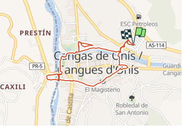
Trail Walking of 2.5 km to be discovered at Asturias, Asturias, Cangas de Onís. This trail is proposed by Papamoju.

Elevation profile

Positioning

Country:
Spain
Region :
Asturias
Department/Province :
Asturias
Municipality :
Cangas de Onís
Location:
Unknown
Start:(UTM)
327746 ; 4802146 (30T) N.

Trails nearby

Trail On foot Cangas de Onís - [TRC-002 R3] Ruta del Rey Pelayo - Photo
On foot
GUIDE+

On foot

Very difficult
Cangas de Onís, Asturias, Asturias, Spain
24 km | 42 km-effort
9h 28min
Yes
Trail On foot Cangas de Onís - [TRC-002 R2] Ruta del Rey Favila - Photo
On foot
GUIDE+

On foot

Medium
Cangas de Onís, Asturias, Asturias, Spain
17.3 km | 26 km-effort
5h 54min
Yes
Trail On foot Cangas de Onís - [TRC-002 R1] Ruta del Puentón - Photo
On foot
GUIDE+

On foot

Easy
Cangas de Onís, Asturias, Asturias, Spain
6.8 km | 10.8 km-effort
2h 26min
Yes


Close
My subscriptions