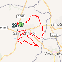
![](/images/other/stat-length.png)
![Trail Walking Entre-Vignes - 34 SAINT-CHRISTOL, promenade dans le village, à travers le vignoble, circuit des croix - Photo](https://media.geolcdn.com/t/1900/400/ext.pjpeg?maxdim=2&url=https%3A%2F%2Fservices.sitytrail.com%2FGeolivesWS%2FDownloadMedia.ashx%3FTrailID%3D478425%26Media%3D20151003171939.jpg)
34 SAINT-CHRISTOL, promenade dans le village, à travers le vignoble, circuit des croix
jeff66
User
![Length](/images/other/stat-length.png)
![Max alt](https://static1.geolcdn.com/siteimages/upload/files/1508320355ic_sort_altitude_max_24dp.png)
![Uphill gradient](https://static1.geolcdn.com/siteimages/upload/files/1508320355ic_sort_den_pos_24dp.png)
![Km-Effort](/images/other/stat-length.png)
![Min alt](https://static1.geolcdn.com/siteimages/upload/files/1508320355ic_sort_altitude_min_24dp.png)
![Downhill gradient](https://static1.geolcdn.com/siteimages/upload/files/1508320355ic_sort_den_neg_24dp.png)
![Boucle](https://static1.geolcdn.com/siteimages/upload/files/16400158638029165_repeat_loop_refresh_sync_direction_icon.png)
![Walking](https://static1.geolcdn.com/sitytour/trail-icons/101.png)
1h49
Difficulty : Medium
![Scan this QR Code to open this trail in the SityTrail application](https://capi.geolives.com/qq0zvz2zws4bq2lad0pu/sitytour/trails/478425/qr.png?size=200)
FREE GPS app for hiking
About
Trail Walking of 10 km to be discovered at Occitania, Hérault, Entre-Vignes. This trail is proposed by jeff66.
Description
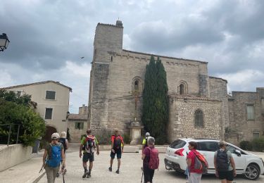
34 SAINT-CHRISTOL -!parking ancienne gare. Maison de la solidarité, Boulodrome Antoine Molina, cave Coop., RD118, avenue saint-christiphe, Domaine Guinand, avenue de la Bouvine, arènes, mairie, places du christ, des chevaliers de Malte, rue du marché, de la signade, rue du Languedoc, du centre, des nouvelles, avenue des bruyères, chemin du Viala, pépinière l'arc en fleurs, rue des mimosas - font Guinière - complexe sportif, stade Antoine Miralles - Viavino - la glacière - emprunter RD110E2 - camp Carretier - la Sergue - Cammau - emprunter RD618 - la pinède - Predaïau - allée bordée d'Oliviers et de cyprès vers le château des hospitaliers - le bois de l'hôpital - chemin de Predaïau - centre canin - fond dans d'aube - chemin des près - jardins familiaux - traverser la RD105 - clos des vignes
Positioning
Comments
Trails nearby
![Trail Walking Saussines - Saussines - Photo](https://media.geolcdn.com/t/375/260/ext.jpg?maxdim=2&url=https%3A%2F%2Fstatic1.geolcdn.com%2Fsiteimages%2Fupload%2Ffiles%2F1553511878bg_sport_marche.png)
![Walking Walking](https://static1.geolcdn.com/sitytour/trail-icons/101.png)
Walking
![](/images/other/stat-length.png)
![](https://static1.geolcdn.com/siteimages/upload/files/16400158638029165_repeat_loop_refresh_sync_direction_icon.png)
![Trail Walking Saint-Geniès-des-Mourgues - 30 beaulieu - Photo](https://media.geolcdn.com/t/375/260/e48acc05-ba85-4785-a34a-e2be2133d057.jpg&format=jpg&maxdim=2)
![Walking Walking](https://static1.geolcdn.com/sitytour/trail-icons/101.png)
Walking
![](/images/other/stat-length.png)
![](https://static1.geolcdn.com/siteimages/upload/files/16400158638029165_repeat_loop_refresh_sync_direction_icon.png)
![Trail Walking Saussines - Circuit des capot elles - Photo](https://media.geolcdn.com/t/375/260/6f4a9959-1f02-425b-b581-c3419555dbfc.jpg&format=jpg&maxdim=2)
![Walking Walking](https://static1.geolcdn.com/sitytour/trail-icons/101.png)
Walking
![](/images/other/stat-length.png)
![](https://static1.geolcdn.com/siteimages/upload/files/16400158638029165_repeat_loop_refresh_sync_direction_icon.png)
![Trail Electric bike Junas - Boucle de la Vidourle - Photo](https://media.geolcdn.com/t/375/260/bfea6d61-9a81-4c7f-8a65-551fef99e67d.jpg&format=jpg&maxdim=2)
![Electric bike Electric bike](https://static1.geolcdn.com/sitytour/trail-icons/205.png)
Electric bike
![](/images/other/stat-length.png)
![](https://static1.geolcdn.com/siteimages/upload/files/16400158638029165_repeat_loop_refresh_sync_direction_icon.png)
![Trail Walking Junas - Aubais - Photo](https://media.geolcdn.com/t/375/260/6d98e84b-2918-432b-a42a-3fc4dbb2b5a1.jpeg&format=jpg&maxdim=2)
![Walking Walking](https://static1.geolcdn.com/sitytour/trail-icons/101.png)
![Trail Walking Saussines - Saussines et ses capitelles - Photo](https://media.geolcdn.com/t/375/260/0e3f4dc9-b3d2-4dd3-b56c-054def4dec10.jpg&format=jpg&maxdim=2)
![Walking Walking](https://static1.geolcdn.com/sitytour/trail-icons/101.png)
Walking
![](/images/other/stat-length.png)
![](https://static1.geolcdn.com/siteimages/upload/files/16400158638029165_repeat_loop_refresh_sync_direction_icon.png)
![Trail Walking Lunel - lunel_tour_de_farge - Photo](https://media.geolcdn.com/t/375/260/b70d97a3-9eda-4743-80e9-10a2f0f582c3.jpg&format=jpg&maxdim=2)
![Walking Walking](https://static1.geolcdn.com/sitytour/trail-icons/101.png)
Walking
![](/images/other/stat-length.png)
![](https://static1.geolcdn.com/siteimages/upload/files/16400158638029165_repeat_loop_refresh_sync_direction_icon.png)
![Trail Walking Saussines - Saussine, sentier des Romains - Photo](https://media.geolcdn.com/t/375/260/0836bc44-bd2a-4d13-93c8-7797a8f68ea7.jpg&format=jpg&maxdim=2)
![Walking Walking](https://static1.geolcdn.com/sitytour/trail-icons/101.png)
Walking
![](/images/other/stat-length.png)
![](https://static1.geolcdn.com/siteimages/upload/files/16400158638029165_repeat_loop_refresh_sync_direction_icon.png)
![Trail Walking Saussines - Saussines Les Capitelles de la Benovie - Photo](https://media.geolcdn.com/t/375/260/fdb3b940-9103-456c-b077-11ff4f962f60.jpg&format=jpg&maxdim=2)
![Walking Walking](https://static1.geolcdn.com/sitytour/trail-icons/101.png)
Walking
![](/images/other/stat-length.png)
![](https://static1.geolcdn.com/siteimages/upload/files/16400158638029165_repeat_loop_refresh_sync_direction_icon.png)