Trail Walking Gérardmer - Orientation Mauselaine - Photo

Orientation Mauselaine

© OpenStreetMap contributors
Length
Length
8.3 km
Max alt
Max alt
1096 m
Uphill gradient
Uphill gradient
636 m
Km-Effort
Km-Effort  
16.8 km
Min alt
Min alt
857 m
Downhill gradient
Downhill gradient
636 m
Boucle
Boucle
Yes
Creation date :
2015-09-30 00:00:00.0
Updated on :
2015-09-30 00:00:00.0

(0 Reviews)

Walking
Walking
2h00
Difficulty : Medium

Scan this QR Code to open this trail in the SityTrail application

FREE GPS app for hiking

Logo SityTrail SityTrail

IGN / Geographical institutes

Download SityTrail from the App Store Download SityTrail from Google Play

Logo SityTrail SityTrail World

The world is yours!

Download SityTrail from the App Store Download SityTrail from Google Play Download SityTrail on Huawei AppGallery

About

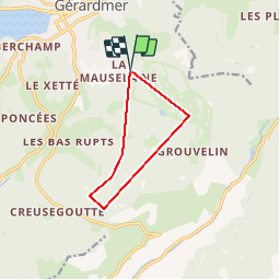
Trail Walking of 8.3 km to be discovered at Grand Est, Vosges, Gérardmer. This trail is proposed by lerandonneur65.

Description

Parcours anti horlogique
1 Sommet
2 Coin S de bâtiment
3 Jonction de chemins
4 Sommet
5 Pointe  S  de landes
6 Pointe  SSE  de fôret

Elevation profile

Points of interest

Point of interest Gérardmer - Départ / arrivée - Photo
lerandonneur65
GÉRARDMER 
Point of interest Gérardmer - 1 - Photo
lerandonneur65
GÉRARDMER 
Point of interest Gérardmer - 2 - Photo
lerandonneur65
GÉRARDMER 
Point of interest Gérardmer - 3 - Photo
lerandonneur65
GÉRARDMER 
Point of interest Gérardmer - 4 - Photo
lerandonneur65
GÉRARDMER 
Point of interest Gérardmer - 5 - Photo
lerandonneur65
GÉRARDMER 
Point of interest Gérardmer - 6 - Photo
lerandonneur65
GÉRARDMER 

Positioning

Country:
France
Region :
Grand Est
Department/Province :
Vosges
Municipality :
Gérardmer
Location:
Unknown
Start:(UTM)
342972 ; 5325031 (32U) N.

Trails nearby

Trail Walking La Bresse - 2023-04-15 Marche Abri Collet de Etang vers Abri Lac de Blanchemer - Photo
Walking
GUIDE
holtzv

Walking

Medium
(1)
La Bresse, Grand Est, Vosges, France
22 km | 35 km-effort
7h 51min
No
Trail Walking La Bresse - Lac de Lispach et sentier Dielaine  - Photo
Walking
zazie

Walking

Medium
(1)
La Bresse, Grand Est, Vosges, France
9.7 km | 14.9 km-effort
2h 30min
Yes
Trail Nordic walking Gérardmer - ramonchamp. observatoire de merelle, saut de la bourrique  - Photo
Nordic walking
francislassauce

Nordic walking

Difficult
(1)
Gérardmer, Grand Est, Vosges, France
11.1 km | 15.8 km-effort
3h 30min
Yes
Trail Walking La Bresse - lac de Lispach - Photo
Walking
fedinois1

Walking

Easy
(1)
La Bresse, Grand Est, Vosges, France
10.4 km | 14.1 km-effort
4h 6min
Yes
Trail Walking La Bresse - lac de Lispach - Photo
Walking
fedinois1

Walking

Easy
(3)
La Bresse, Grand Est, Vosges, France
10.4 km | 14.1 km-effort
4h 6min
Yes
Trail Mountain bike La Bresse - randonnée découverte à la Bresse.  - Photo
Mountain bike
Dutyrider

Mountain bike

Easy
(1)
La Bresse, Grand Est, Vosges, France
30 km | 41 km-effort
2h 58min
Yes
Trail Walking Ban-sur-Meurthe-Clefcy - La vallée de Belbriette - Ban-sur-Meurthe-Clefcy - Photo
Walking
tracegps

Walking

Medium
(2)
Ban-sur-Meurthe-Clefcy, Grand Est, Vosges, France
9.8 km | 12.6 km-effort
2h 30min
Yes
Trail Walking Gérardmer - La Tête de Mérelle - Photo
Walking
tracegps

Walking

Medium
(4)
Gérardmer, Grand Est, Vosges, France
4.7 km | 9 km-effort
2h 30min
Yes
Trail Walking Gérardmer - gerardmer - la mauselaine . tête grauvelin . Roche boquet . croix claudé . hautes Vannes . la mauselaine  - Photo
Walking
stef789

Walking

Very easy
(1)
Gérardmer, Grand Est, Vosges, France
11.3 km | 16.2 km-effort
3h 42min
Yes


Close
My subscriptions