![](/images/other/stat-length.png)
![Trail Cycle Rocamadour - Le Nord-Est de Rocamadour - Photo](https://media.geolcdn.com/t/1900/400/ext.pjpeg?maxdim=2&url=https%3A%2F%2Fservices.sitytrail.com%2FGeolivesWS%2FDownloadMedia.ashx%3FTrailID%3D475007%26Media%3D4e7824b3-7913-44b4-a222-f782cd306375.jpg)
Le Nord-Est de Rocamadour
destras
User
![Length](/images/other/stat-length.png)
Length
69 km
![Max alt](https://static1.geolcdn.com/siteimages/upload/files/1508320355ic_sort_altitude_max_24dp.png)
Max alt
421 m
![Uphill gradient](https://static1.geolcdn.com/siteimages/upload/files/1508320355ic_sort_den_pos_24dp.png)
Uphill gradient
1157 m
![Km-Effort](/images/other/stat-length.png)
Km-Effort
84 km
![Min alt](https://static1.geolcdn.com/siteimages/upload/files/1508320355ic_sort_altitude_min_24dp.png)
Min alt
126 m
![Downhill gradient](https://static1.geolcdn.com/siteimages/upload/files/1508320355ic_sort_den_neg_24dp.png)
Downhill gradient
1160 m
![Boucle](https://static1.geolcdn.com/siteimages/upload/files/16400158638029165_repeat_loop_refresh_sync_direction_icon.png)
Boucle
Yes
Creation date :
2016-03-09 00:00:00.0
Updated on :
2016-03-09 00:00:00.0
![Cycle](https://static1.geolcdn.com/sitytour/trail-icons/200.png)
4h48
Difficulty : Difficult
![Scan this QR Code to open this trail in the SityTrail application](https://capi.geolives.com/qq0zvz2zws4bq2lad0pu/sitytour/trails/475007/qr.png?size=200)
FREE GPS app for hiking
About
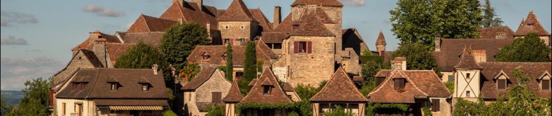
Trail Cycle of 69 km to be discovered at Occitania, Lot, Rocamadour. This trail is proposed by destras.
Description
boucle au nord-est de Rocamadour avec un tour à Rocamadour. Départ du hameau Blanat.
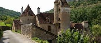
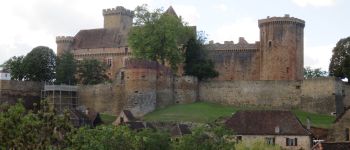
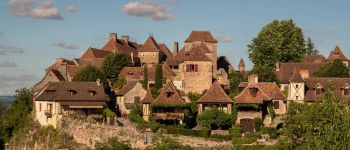
Je suis passé par deux plus beaux villages de France, Autoire, Loubressac.
Positioning
Country:
France
Region :
Occitania
Department/Province :
Lot
Municipality :
Rocamadour
Location:
Unknown
Start:(Dec)
Start:(UTM)
394781 ; 4962489 (31T) N.
Comments
Trails nearby
![Trail Walking Rocamadour - Col de mages Lafage Rocamadour La Panonie - Photo](https://media.geolcdn.com/t/375/260/9f4a7e91-ac8d-4857-be4f-8e26f11cf7f3.jpg&format=jpg&maxdim=2)
![Walking Walking](https://static1.geolcdn.com/sitytour/trail-icons/101.png)
Col de mages Lafage Rocamadour La Panonie
Walking
Easy
(1)
Rocamadour,
Occitania,
Lot,
France
![](/images/other/stat-length.png)
16.6 km | 22 km-effort
3h 57min
![](https://static1.geolcdn.com/siteimages/upload/files/16400158638029165_repeat_loop_refresh_sync_direction_icon.png)
Yes
![Trail Walking Alvignac - Le grand tour d'Alvignac Les Eaux - Photo](https://media.geolcdn.com/t/375/260/ext.jpg?maxdim=2&url=https%3A%2F%2Fservices.sitytrail.com%2FGeolivesWS%2FDownloadMedia.ashx%3FTrailID%3D111869%26Media%3D8685_4.jpg)
![Walking Walking](https://static1.geolcdn.com/sitytour/trail-icons/101.png)
Le grand tour d'Alvignac Les Eaux
Walking
Difficult
(1)
Alvignac,
Occitania,
Lot,
France
![](/images/other/stat-length.png)
15.2 km | 19.3 km-effort
3h 49min
![](https://static1.geolcdn.com/siteimages/upload/files/16400158638029165_repeat_loop_refresh_sync_direction_icon.png)
Yes
![Trail Walking Gramat - Moulin du saut - Photo](https://media.geolcdn.com/t/375/260/81ea1c7f-a2c4-42fc-9927-d2aa00c3944a.jpg&format=jpg&maxdim=2)
![Walking Walking](https://static1.geolcdn.com/sitytour/trail-icons/101.png)
![Trail On foot Rocamadour - Boucle de randonnée entre Rocamadour et le Gouffre de Padirac - Photo](https://media.geolcdn.com/t/375/260/80b0432d-439e-456c-9615-ea85758f11af.jpeg&format=jpg&maxdim=2)
![On foot On foot](https://static1.geolcdn.com/sitytour/trail-icons/100.png)
Boucle de randonnée entre Rocamadour et le Gouffre de Padirac
On foot
Very difficult
Rocamadour,
Occitania,
Lot,
France
![](/images/other/stat-length.png)
42 km | 53 km-effort
12h 2min
![](https://static1.geolcdn.com/siteimages/upload/files/16400158638029165_repeat_loop_refresh_sync_direction_icon.png)
No
![Trail Walking Rignac - Rignac - Photo](https://media.geolcdn.com/t/375/260/83907e68-b86a-4a58-992d-16a35c4deef5.jpg&format=jpg&maxdim=2)
![Walking Walking](https://static1.geolcdn.com/sitytour/trail-icons/101.png)
SityTrail - Rocamadour
Walking
Difficult
Rocamadour,
Occitania,
Lot,
France
![](/images/other/stat-length.png)
13.9 km | 17.8 km-effort
4h 2min
![](https://static1.geolcdn.com/siteimages/upload/files/16400158638029165_repeat_loop_refresh_sync_direction_icon.png)
Yes
![Trail Walking Gramat - alzou gorges - Photo](https://media.geolcdn.com/t/375/260/fa7c3de3-dc73-4d5f-86fc-1696475a59ed.jpg&format=jpg&maxdim=2)
![Walking Walking](https://static1.geolcdn.com/sitytour/trail-icons/101.png)
![Trail Walking Rocamadour - Rocamadour cougnaguet calouet - Photo](https://media.geolcdn.com/t/375/260/d5650960-8085-450c-a78d-c7c16a2ada0f.jpg&format=jpg&maxdim=2)
![Walking Walking](https://static1.geolcdn.com/sitytour/trail-icons/101.png)
Rocamadour cougnaguet calouet
Walking
Easy
Rocamadour,
Occitania,
Lot,
France
![](/images/other/stat-length.png)
17.7 km | 24 km-effort
4h 51min
![](https://static1.geolcdn.com/siteimages/upload/files/16400158638029165_repeat_loop_refresh_sync_direction_icon.png)
Yes
![Trail Walking Rocamadour - Rocamadour , magés , moulins du saut - Photo](https://media.geolcdn.com/t/375/260/51833c9c-a710-4054-bb36-7a2bcfc341c1.jpg&format=jpg&maxdim=2)
![Walking Walking](https://static1.geolcdn.com/sitytour/trail-icons/101.png)
Rocamadour , magés , moulins du saut
Walking
Easy
Rocamadour,
Occitania,
Lot,
France
![](/images/other/stat-length.png)
46 km | 56 km-effort
4h 41min
![](https://static1.geolcdn.com/siteimages/upload/files/16400158638029165_repeat_loop_refresh_sync_direction_icon.png)
No