![](/images/other/stat-length.png)
![Trail Walking Germ - pic de Hourgade - Photo](https://media.geolcdn.com/t/1900/400/ext.pjpeg?maxdim=2&url=https%3A%2F%2Fstatic1.geolcdn.com%2Fsiteimages%2Fupload%2Ffiles%2F1553511878bg_sport_marche.png)
pic de Hourgade
dawed311
User
![Length](/images/other/stat-length.png)
Length
8.3 km
![Max alt](https://static1.geolcdn.com/siteimages/upload/files/1508320355ic_sort_altitude_max_24dp.png)
Max alt
2919 m
![Uphill gradient](https://static1.geolcdn.com/siteimages/upload/files/1508320355ic_sort_den_pos_24dp.png)
Uphill gradient
1182 m
![Km-Effort](/images/other/stat-length.png)
Km-Effort
20 km
![Min alt](https://static1.geolcdn.com/siteimages/upload/files/1508320355ic_sort_altitude_min_24dp.png)
Min alt
1841 m
![Downhill gradient](https://static1.geolcdn.com/siteimages/upload/files/1508320355ic_sort_den_neg_24dp.png)
Downhill gradient
111 m
![Boucle](https://static1.geolcdn.com/siteimages/upload/files/16400158638029165_repeat_loop_refresh_sync_direction_icon.png)
Boucle
No
Creation date :
2019-05-09 20:39:04.795
Updated on :
2019-05-09 20:39:05.101
![Walking](https://static1.geolcdn.com/sitytour/trail-icons/101.png)
4h14
Difficulty : Medium
![Scan this QR Code to open this trail in the SityTrail application](https://capi.geolives.com/qq0zvz2zws4bq2lad0pu/sitytour/trails/473912/qr.png?size=200)
FREE GPS app for hiking
About
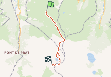
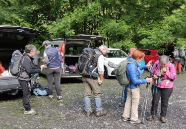
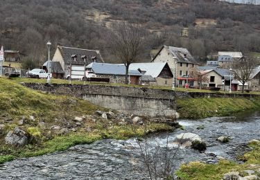
Trail Walking of 8.3 km to be discovered at Occitania, Hautespyrenees, Germ. This trail is proposed by dawed311.
Description
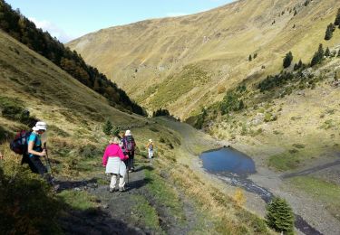
Superbe et vaste panorama au sommet. De nombreux lac sont visibles. Itinéraire classique au Pic de Hourgade. Attention à bien contourner le premier lac par la droite, puis le second par la gauche.
Le sentier en balcon jusqu'à Peyragudes semble interminable.
Positioning
Country:
France
Region :
Occitania
Department/Province :
Hautespyrenees
Municipality :
Germ
Location:
Unknown
Start:(Dec)
Start:(UTM)
290794 ; 4739437 (31T) N.
Comments
Trails nearby
![Trail Walking Loudenvielle - Le refuge de la Soula - Photo](https://media.geolcdn.com/t/375/260/ext.jpg?maxdim=2&url=https%3A%2F%2Fservices.sitytrail.com%2FGeolivesWS%2FDownloadMedia.ashx%3FTrailID%3D343973%26Media%3Dfix__20140910123118.jpg)
![Walking Walking](https://static1.geolcdn.com/sitytour/trail-icons/101.png)
Le refuge de la Soula
Walking
Difficult
(1)
Loudenvielle,
Occitania,
Hautespyrenees,
France
![](/images/other/stat-length.png)
13 km | 22 km-effort
5h 0min
![](https://static1.geolcdn.com/siteimages/upload/files/16400158638029165_repeat_loop_refresh_sync_direction_icon.png)
Yes
![Trail Walking Portet-de-Luchon - Du Col de Peyresourde au sommet du Pouyaué - Loudervielle - Photo](https://media.geolcdn.com/t/375/260/ext.jpg?maxdim=2&url=https%3A%2F%2Fservices.sitytrail.com%2FGeolivesWS%2FDownloadMedia.ashx%3FTrailID%3D173038%26Media%3D14554_6.jpg)
![Walking Walking](https://static1.geolcdn.com/sitytour/trail-icons/101.png)
Du Col de Peyresourde au sommet du Pouyaué - Loudervielle
Walking
Difficult
(1)
Portet-de-Luchon,
Occitania,
Haute-Garonne,
France
![](/images/other/stat-length.png)
9.9 km | 18.4 km-effort
4h 10min
![](https://static1.geolcdn.com/siteimages/upload/files/16400158638029165_repeat_loop_refresh_sync_direction_icon.png)
Yes
![Trail Walking Loudenvielle - Val d'Aube - Photo](https://media.geolcdn.com/t/375/260/ext.jpg?maxdim=2&url=https%3A%2F%2Fservices.sitytrail.com%2FGeolivesWS%2FDownloadMedia.ashx%3FTrailID%3D334907%26Media%3Dfix__20140814144319.jpg)
![Walking Walking](https://static1.geolcdn.com/sitytour/trail-icons/101.png)
Val d'Aube
Walking
Medium
(3)
Loudenvielle,
Occitania,
Hautespyrenees,
France
![](/images/other/stat-length.png)
11.1 km | 19.5 km-effort
4h 19min
![](https://static1.geolcdn.com/siteimages/upload/files/16400158638029165_repeat_loop_refresh_sync_direction_icon.png)
Yes
![Trail Walking Oô - LUCHON Lac D Oo G3](https://media.geolcdn.com/t/375/260/8f5fd43e-037c-40ed-bcb2-fcca5101f846.jpg&format=jpg&maxdim=2)
![Walking Walking](https://static1.geolcdn.com/sitytour/trail-icons/101.png)
LUCHON Lac D Oo G3 "4099085"
Walking
Medium
Oô,
Occitania,
Haute-Garonne,
France
![](/images/other/stat-length.png)
6.9 km | 12 km-effort
2h 43min
![](https://static1.geolcdn.com/siteimages/upload/files/16400158638029165_repeat_loop_refresh_sync_direction_icon.png)
Yes
![Trail Walking Loudenvielle - Cabana d'ourtigas - Photo](https://media.geolcdn.com/t/375/260/ext.jpg?maxdim=2&url=https%3A%2F%2Fstatic1.geolcdn.com%2Fsiteimages%2Fupload%2Ffiles%2F1553511878bg_sport_marche.png)
![Walking Walking](https://static1.geolcdn.com/sitytour/trail-icons/101.png)
Cabana d'ourtigas
Walking
Very easy
(1)
Loudenvielle,
Occitania,
Hautespyrenees,
France
![](/images/other/stat-length.png)
14.2 km | 24 km-effort
6h 59min
![](https://static1.geolcdn.com/siteimages/upload/files/16400158638029165_repeat_loop_refresh_sync_direction_icon.png)
Yes
![Trail Walking Germ - GERM la cabane d Ourtiga G3 fait - Photo](https://media.geolcdn.com/t/375/260/2e736210-e73c-4bad-ba88-e25ece772a2a.jpg&format=jpg&maxdim=2)
![Walking Walking](https://static1.geolcdn.com/sitytour/trail-icons/101.png)
GERM la cabane d Ourtiga G3 fait
Walking
Medium
Germ,
Occitania,
Hautespyrenees,
France
![](/images/other/stat-length.png)
10.6 km | 16.4 km-effort
5h 33min
![](https://static1.geolcdn.com/siteimages/upload/files/16400158638029165_repeat_loop_refresh_sync_direction_icon.png)
Yes
![Trail Snowshoes Germ - Germ raquettes le 27 Janvier 2018-fait - Photo](https://media.geolcdn.com/t/375/260/ext.jpg?maxdim=2&url=https%3A%2F%2Fservices.sitytrail.com%2FGeolivesWS%2FDownloadMedia.ashx%3FTrailID%3D895724%26Media%3Dfix__20180128125818.jpg)
![Snowshoes Snowshoes](https://static1.geolcdn.com/sitytour/trail-icons/504.png)
Germ raquettes le 27 Janvier 2018-fait
Snowshoes
Medium
Germ,
Occitania,
Hautespyrenees,
France
![](/images/other/stat-length.png)
5.3 km | 9.1 km-effort
5h 7min
![](https://static1.geolcdn.com/siteimages/upload/files/16400158638029165_repeat_loop_refresh_sync_direction_icon.png)
Yes
![Trail Walking Oô - Seil de la Baque - Photo](https://media.geolcdn.com/t/375/260/ext.jpg?maxdim=2&url=https%3A%2F%2Fstatic1.geolcdn.com%2Fsiteimages%2Fupload%2Ffiles%2F1553511878bg_sport_marche.png)
![Walking Walking](https://static1.geolcdn.com/sitytour/trail-icons/101.png)
Seil de la Baque
Walking
Difficult
(1)
Oô,
Occitania,
Haute-Garonne,
France
![](/images/other/stat-length.png)
28 km | 56 km-effort
11h 9min
![](https://static1.geolcdn.com/siteimages/upload/files/16400158638029165_repeat_loop_refresh_sync_direction_icon.png)
Yes
![Trail Walking Gouaux-de-Larboust - Boucle autour d’Oô - Photo](https://media.geolcdn.com/t/375/260/c8e9cdf8-0d07-4843-a925-3f7cf6a578dc.jpeg&format=jpg&maxdim=2)
![Walking Walking](https://static1.geolcdn.com/sitytour/trail-icons/101.png)
Boucle autour d’Oô
Walking
Gouaux-de-Larboust,
Occitania,
Haute-Garonne,
France
![](/images/other/stat-length.png)
9 km | 15.6 km-effort
3h 5min
![](https://static1.geolcdn.com/siteimages/upload/files/16400158638029165_repeat_loop_refresh_sync_direction_icon.png)
Yes
Très précis, beaucoup de sity guide