![](/images/other/stat-length.png)
![Trail Walking Feldberg - Hochschwarzwald - Photo](https://media.geolcdn.com/t/1900/400/ext.pjpeg?maxdim=2&url=https%3A%2F%2Fstatic1.geolcdn.com%2Fsiteimages%2Fupload%2Ffiles%2F1553511878bg_sport_marche.png)
Hochschwarzwald
michelek
User
![Length](/images/other/stat-length.png)
Length
25 km
![Max alt](https://static1.geolcdn.com/siteimages/upload/files/1508320355ic_sort_altitude_max_24dp.png)
Max alt
1375 m
![Uphill gradient](https://static1.geolcdn.com/siteimages/upload/files/1508320355ic_sort_den_pos_24dp.png)
Uphill gradient
973 m
![Km-Effort](/images/other/stat-length.png)
Km-Effort
38 km
![Min alt](https://static1.geolcdn.com/siteimages/upload/files/1508320355ic_sort_altitude_min_24dp.png)
Min alt
882 m
![Downhill gradient](https://static1.geolcdn.com/siteimages/upload/files/1508320355ic_sort_den_neg_24dp.png)
Downhill gradient
976 m
![Boucle](https://static1.geolcdn.com/siteimages/upload/files/16400158638029165_repeat_loop_refresh_sync_direction_icon.png)
Boucle
Yes
Creation date :
2018-11-10 10:09:04.086
Updated on :
2018-11-10 10:09:04.151
![Walking](https://static1.geolcdn.com/sitytour/trail-icons/101.png)
7h58
Difficulty : Difficult
![Scan this QR Code to open this trail in the SityTrail application](https://capi.geolives.com/qq0zvz2zws4bq2lad0pu/sitytour/trails/473674/qr.png?size=200)
FREE GPS app for hiking
About
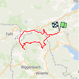
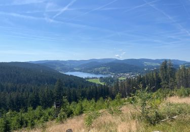
Trail Walking of 25 km to be discovered at Baden-Württemberg, Landkreis Breisgau-Hochschwarzwald, Feldberg. This trail is proposed by michelek.
Description
Belle et longue rando dans la Haute Forêt Noire au départ de Sommerberg. Passage par le joli village de Mensenschwande et sa cascade, ravitaillement à la Krunkelbachhütte puis retour par la station de Feldberg.
Positioning
Country:
Germany
Region :
Baden-Württemberg
Department/Province :
Landkreis Breisgau-Hochschwarzwald
Municipality :
Feldberg
Location:
Altglashütten
Start:(Dec)
Start:(UTM)
433257 ; 5300600 (32T) N.
Comments
Trails nearby
![Trail On foot Feldberg - Altglashütten - Feldberg-Caritashaus - Photo](https://media.geolcdn.com/t/375/260/09e36bd8-d689-4eac-b51e-56f2a9bb44ed.jpeg&format=jpg&maxdim=2)
![On foot On foot](https://static1.geolcdn.com/sitytour/trail-icons/100.png)
Altglashütten - Feldberg-Caritashaus
On foot
Easy
Feldberg,
Baden-Württemberg,
Landkreis Breisgau-Hochschwarzwald,
Germany
![](/images/other/stat-length.png)
6.1 km | 9.6 km-effort
2h 11min
![](https://static1.geolcdn.com/siteimages/upload/files/16400158638029165_repeat_loop_refresh_sync_direction_icon.png)
No
![Trail On foot Feldberg - Feldberg (Caritasheim) - Kohlplatz - Bärental - Photo](https://media.geolcdn.com/t/375/260/e19e595e-ef64-4cea-8b0b-35be2d93dd41.jpeg&format=jpg&maxdim=2)
![On foot On foot](https://static1.geolcdn.com/sitytour/trail-icons/100.png)
Feldberg (Caritasheim) - Kohlplatz - Bärental
On foot
Easy
Feldberg,
Baden-Württemberg,
Landkreis Breisgau-Hochschwarzwald,
Germany
![](/images/other/stat-length.png)
4.2 km | 5.2 km-effort
1h 10min
![](https://static1.geolcdn.com/siteimages/upload/files/16400158638029165_repeat_loop_refresh_sync_direction_icon.png)
No
![Trail On foot Schluchsee - Aha - Altglashütten - Photo](https://media.geolcdn.com/t/375/260/fbef3630-0250-410c-a6a1-80448ac48f09.jpeg&format=jpg&maxdim=2)
![On foot On foot](https://static1.geolcdn.com/sitytour/trail-icons/100.png)
Aha - Altglashütten
On foot
Easy
Schluchsee,
Baden-Württemberg,
Landkreis Breisgau-Hochschwarzwald,
Germany
![](/images/other/stat-length.png)
4 km | 5.1 km-effort
1h 9min
![](https://static1.geolcdn.com/siteimages/upload/files/16400158638029165_repeat_loop_refresh_sync_direction_icon.png)
No
![Trail On foot Schluchsee - Jägersteig - Photo](https://media.geolcdn.com/t/375/260/e6618854-799a-4113-a147-f68601b347d5.jpeg&format=jpg&maxdim=2)
![On foot On foot](https://static1.geolcdn.com/sitytour/trail-icons/100.png)
Jägersteig
On foot
Easy
Schluchsee,
Baden-Württemberg,
Landkreis Breisgau-Hochschwarzwald,
Germany
![](/images/other/stat-length.png)
11.6 km | 15.8 km-effort
3h 35min
![](https://static1.geolcdn.com/siteimages/upload/files/16400158638029165_repeat_loop_refresh_sync_direction_icon.png)
Yes
![Trail On foot Schluchsee - DE-Ehemalige Krummensäge - Kohlhütte - fixme - Photo](https://media.geolcdn.com/t/375/260/00edd11d-5774-4c7d-84eb-be79de7d632d.jpeg&format=jpg&maxdim=2)
![On foot On foot](https://static1.geolcdn.com/sitytour/trail-icons/100.png)
DE-Ehemalige Krummensäge - Kohlhütte - fixme
On foot
Easy
Schluchsee,
Baden-Württemberg,
Landkreis Breisgau-Hochschwarzwald,
Germany
![](/images/other/stat-length.png)
3.1 km | 3.6 km-effort
49min
![](https://static1.geolcdn.com/siteimages/upload/files/16400158638029165_repeat_loop_refresh_sync_direction_icon.png)
No
![Trail On foot Schluchsee - DE-Muchenländer Brücke - Schubenwald - Photo](https://media.geolcdn.com/t/375/260/3870eac4-99dd-48db-b536-97eebeedc4f9.jpeg&format=jpg&maxdim=2)
![On foot On foot](https://static1.geolcdn.com/sitytour/trail-icons/100.png)
DE-Muchenländer Brücke - Schubenwald
On foot
Easy
Schluchsee,
Baden-Württemberg,
Landkreis Breisgau-Hochschwarzwald,
Germany
![](/images/other/stat-length.png)
4 km | 6.9 km-effort
1h 33min
![](https://static1.geolcdn.com/siteimages/upload/files/16400158638029165_repeat_loop_refresh_sync_direction_icon.png)
No
![Trail On foot St. Blasien - Feldberg - Schluchsee - Photo](https://media.geolcdn.com/t/375/260/5582e00c-6942-431c-81b3-3edf83af516e.jpeg&format=jpg&maxdim=2)
![On foot On foot](https://static1.geolcdn.com/sitytour/trail-icons/100.png)
Feldberg - Schluchsee
On foot
Easy
St. Blasien,
Baden-Württemberg,
Landkreis Waldshut,
Germany
![](/images/other/stat-length.png)
11.2 km | 14.7 km-effort
3h 20min
![](https://static1.geolcdn.com/siteimages/upload/files/16400158638029165_repeat_loop_refresh_sync_direction_icon.png)
No
![Trail Walking Feldberg - Feldsee & Feldberg - Photo](https://media.geolcdn.com/t/375/260/8f4f5518-8987-4474-9626-9d838368cf80.jpg&format=jpg&maxdim=2)
![Walking Walking](https://static1.geolcdn.com/sitytour/trail-icons/101.png)
Feldsee & Feldberg
Walking
Very difficult
Feldberg,
Baden-Württemberg,
Landkreis Breisgau-Hochschwarzwald,
Germany
![](/images/other/stat-length.png)
15.8 km | 23 km-effort
7h 7min
![](https://static1.geolcdn.com/siteimages/upload/files/16400158638029165_repeat_loop_refresh_sync_direction_icon.png)
Yes
![Trail Electric bike Titisee-Neustadt - Bärental, Altglashütte, Falkau, Saig, Neustadt Titisee - Photo](https://media.geolcdn.com/t/375/260/b9be378f-8400-4277-b69c-0380f875a18d.jpg&format=jpg&maxdim=2)
![Electric bike Electric bike](https://static1.geolcdn.com/sitytour/trail-icons/205.png)
Bärental, Altglashütte, Falkau, Saig, Neustadt Titisee
Electric bike
Medium
Titisee-Neustadt,
Baden-Württemberg,
Landkreis Breisgau-Hochschwarzwald,
Germany
![](/images/other/stat-length.png)
29 km | 37 km-effort
4h 43min
![](https://static1.geolcdn.com/siteimages/upload/files/16400158638029165_repeat_loop_refresh_sync_direction_icon.png)
No